St Briavels Circular
Pub Walk + Woodland Walk + Countryside Walk
Region - Wye Valley Forest of Dean
County/Area - Gloucestershire
Author - Lou Johnson
Length - 7.5 miles / 12.2 km Ascent - 850 feet / 258 metres
Time - 4 hours 40 minutes Grade - easy/mod
Maps 

| Ordnance Survey Explorer OL14 | Sheet Map | 1:25k | BUY |
| Anquet OS Explorer OL14 | Digital Map | 1:25k | BUY |
Walk Route Description
Click image to see photo description.
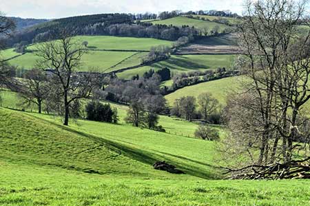
Starting from the hilltop village of St Briavels (Glos.) this walk explores an area of countryside and woodland lying to the east in the Forest of Dean. The undulating route uses woodland and field paths including a section of the Gloucestershire Way. The start is East Street in St Briavels (grid ref. SO560045) where on street parking is generally available. If you are planning to be a patron, then use the George Inn car park.
After parking walk to the George Inn and take Church Street which runs beside the right-hand end of the George Inn. Reaching St Mary the Virgin church, turn right through a gate into the churchyard and continue through to the far corner and exit onto a lane. Turn right and at the next junction fork right along a lane unsuitable for motor vehicles. To your left there is a grand view down into a side valley which leads to the River Wye. Continue along Mork Lane and fork right with a fingerpost on the left of the track. Follow the track and follow the yellow waymarks leading through a garden and into a field. The path descends to enter woodland after 500 metres (grid ref. SO561053). The path soon climbs with Slade Bottom down to your left. Continue along the woodland path to reach the B4228 (Grid ref. SO572051).
Turn left and after 150 metres, turn right along a bridleway. Continue through woodland, pass Roads Farm on your right to reach a junction of tracks with an adjacent an adjacent house (Road House), turn right and continue along the track enclosed with hedges for 800 metres to reach Bream Road (grid ref. SO579045). Turn left and after 250 metres turn right into a field with adjacent fingerpost. Bear left and follow the left-hand edge of two fields to approach Willsbury Farm. Just before the farm, turn right to join the Gloucestershire Way. The grassy path soon bends right before turning left to pass a pond on your left. The onwards route descends through woodland (Rodland Grove) to reach Rodmore Lane (grid ref. SO588028) after a kilometre through trees.
Turn right along the lane and continue ahead for 600 metres past a white house surrounded by fields on your left. The lane bends right. Ignore the first footpath on the left and continue to where a track forks downhill on your left. Follow this track Keep ahead at the first junction and follow the path through Pickethill Wood and exit over a stile into fields (grid ref. SO578028). The rising path heads to the left of Highgrove Farm to reach a junction of paths in a clump of trees (grid ref. SO570034). Turn left and follow a rising path beside a hedge on your right. Keep ahead at a path junction and follow the onward path which runs to the right of Aylesmore Court. Once past the buildings turn right and follow the path heading north. After just over a kilometre the path leads into Hewelsfield Lane on the outskirts of St Briavels. Go straight across the B4228 and pass to the right of a wooden barrier. At the first junction turn right into Pystol Lane. Follow this lane to High Street and turn right. High Street soon becomes East Street where you started the walk.
Other walks nearby
| Walk 2832 | The Wye Valley | easy/mod | 5.8 miles |
| Walk 1272 | Tintern, Devil's Pulpit & Brockweir | moderate | 7.5 miles |
| Walk 3214 | Symonds Yat, High Meadow Woods & Wye Valley | moderate | 12.0 miles |
| Walk 3302 | Symonds Yat Rock and the Biblins | easy/mod | 4.0 miles |
| Walk 1927 | Oldbury-on-Severn & Littleton-upon-Severn | easy | 5.2 miles |
| Walk 3750 | River Severn from Arlingham | easy | 6.0 miles |
| Walk 3437 | The Severn Estuary from Thornbury | easy/mod | 9.3 miles |
| Walk 2147 | Arlington Peninsula from Saul Junction | easy/mod | 6.2 miles |
| Walk 1874 | The River Usk from Bettws Newydd | easy/mod | 6.5 miles |
| Walk 1258 | The Tyndale Monument | easy/mod | 5.5 miles |
Recommended Books & eBooks
Walking in the Forest of Dean
 Guidebook to 25 walks in the Forest of Dean, between the Severn and Wye, from 4-mile routes to all-day sections of long-distance trails such as the Offa's Dyke Path and Gloucestershire Way, this guide is ideal for exploring the forest and its history and includes the information needed for walkers of all abilities to explore this ancient area.
More information
Walking in the Wye Valley
 Guidebook to 30 varied walks of 3 - 10 miles, in the valley of the Wye, the most scenic river in England and Wales, between Chepstow in the south and Plynlimon. Landscape ranges from open moorland to wooded gorges and is dotted with the sites of Iron Age hillforts and castles. Centres include Ross-on-Wye, Hereford, Hay-on-Wye and Rhayader.
More information
Messaging & Social Media
Message Walking Britain and follow the latest news.

Mountain Weather
Stay safe on the mountains with detailed weather forecasts - for iOS devices or for Android devices.