Glyder Ridge traverse from Ogwen Valley
Snowdonia/Eryri Walk
Nat Park - Snowdonia - Glyders Tryfan
County/Area - Gwynedd & Conwy
Author - Lou Johnson
Length - 5.5 miles / 8.9 km Ascent - 2485 feet / 753 metres
Time - 5 hours 10 minutes Grade - hard
Maps 

| Ordnance Survey Explorer OL17 | Sheet Map | 1:25k | BUY |
| Anquet OS Explorer OL17 | Digital Map | 1:25k | BUY |
| Ordnance Survey Landranger 115 | Sheet Map | 1:50k | BUY |
| Anquet OS Landranger 115 | Digital Map | 1:50k | BUY |
Walk Route Description
Click image to visit gallery of 3 images.
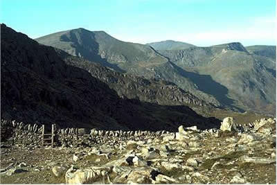
The Glyders form a compact range of mountains lying to the west of the A5 main road between Bangor and Capel Curig. In contrast to the relatively smooth outlines of the western flank, the eastern flank facing the A5 is craggy and full of interest. The main objective of this walk is to visit the two highest summits of the range, Glyder Fawr (3277 ft.) and Glyder Fach (3261 ft.) However it would be possible to include magnificent Tryfan if you have enough energy and an extra hour or so to spend on the mountains. If you were only going to make one walk in the Glyders then this is the one to do. Packed full of interest it is in my "top ten" of favourite walks.
The best place to park for this Snowdonia (Eryri) walk is in the small car park at Ogwen Cottage (grid ref.SH 649603) where there is an excellent take-away cafe ready for quenching your thirst on return to your car. Take the well constructed path heading south. After a few hundred yards bear left and start the steady and interesting climb up to the shores of Lake Bochlwyd which is an ideal place to have your first rest. Overlooked by mountains in every direction with Tryfan dominant to the east.
Suitably refreshed continue upwards to Bwlch Tryfan from where it is an easy proposition to climb Tryfan (see walk 3026). From here you need to descend slightly and tackle the steep loose path to the south of the famous Bristly Ridge (ideal for competent scramblers) up to the summit of Glyder Fawr. Initially the path is rough and loose but as height is gained it becomes less steep and easier. However do not let this put you off. The rewards from the summit plateau are well worth the effort.
The Glyder plateau is a stony wasteland (almost a moon-scape) and from Glyder Fach you have an excellent view to Glyder Fawr with the interesting rock formation of Castell y Gwynt (Castle of the Winds) prominent in the foreground. Also of interest is the cantilever rock on which someone is usually perched having their photograph taken. Proceeding roughly west it is hard going over the rocky landscape but the views to Snowdon, the Carneddau and Tryfan are superb. Glyder Fawr is the highest summit of the range and you now find improving vistas over the northern Glyders including Y Garn and Elidir Fawr.
The worst part of the walk is the descent to Llyn y Cwn. The path, on this occasion, was treacherous made of up loose slippery scree. However with patience this was soon overcome and we relaxed ready for the descent down the Devil's Kitchen another highlight of this spectacular walk.
As you start the descent down the rocky stairway the dark waters of Llyn Idwal are far below. This is mountain scenery at its best with crags, cliffs and mountains crowding round the path. We chose the path running to the east of Llyn Idwal and were faced with a tricky crossing of a stream in spate. However this was achieved with dry feet and all that was left was to follow the path underneath the Idwal Slabs and back to the car. The Idwal Slabs were crowded with novice climbers learning their skills on the easy rocks of this well-known crag.
Other walks nearby
| Walk 2650 | Tryfan, the Glyders & Y Garn | very hard | 8.0 miles |
| Walk 2820 | Carneddau traverse from Llyn Ogwen | mod/hard | 14.0 miles |
| Walk 1150 | The High Carneddau | hard | 10.0 miles |
| Walk 1215 | Tryfan & Llyn Ogwen from Ogwen Valley | mod/hard | 5.5 miles |
| Walk 3001 | Tryfan North Ridge from Ogwen Valley | hard | 3.5 miles |
| Walk 3026 | Tryfan & the Eastern Tops from Ogwen Valley | hard | 5.8 miles |
| Walk 1232 | Carnedd Llewelyn, Llyn Eigiau & Llyn Cowlyd | hard | 16.0 miles |
| Walk 2855 | Gallt yr Ogof & Braich y Ddeugwm | moderate | 4.0 miles |
| Walk 3056 | Pen yr Helgi Du from Ogwen Valley | moderate | 5.5 miles |
| Walk 1074 | The Glyders Traverse | very hard | 12.0 miles |
Recommended Books & eBooks
The Cambrian Way
 Guidebook to the Cambrian Way, a challenging three-week mountain trek through Wales from Cardiff to Conwy. The 470km un-waymarked route is presented from south to north. Often sticking to long, beautiful ridgelines, it crosses wild and rugged terrain and visits many of Wales's highest mountains, including Snowdon.
More information
Great Mountain Days in Snowdonia
 Inspirational guidebook to 40 great mountain day walks and scrambles in Snowdonia. Inspirational routes for all abilities across the National Park with routes up Snowdon and Moel Eilio, the Glyderau, the Carneddau, Eifionydd, Siabod and the Moelwynion, Rhinogydd (the Harlech Dome), Migneint and the Arans and Cadair Idris and the Tarrens.
More information
Messaging & Social Media
Message Walking Britain and follow the latest news.

Mountain Weather
Stay safe on the mountains with detailed weather forecasts - for iOS devices or for Android devices.