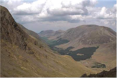
Great Gable from Honister Pass
Lake District Walk
Nat Park - Lake District - Lake District Western Fells
Wainwrights - Brandreth, Great Gable, Green Gable, Grey Knotts
County/Area - Cumbria
Author - Lou Johnson
Length - 7.3 miles / 11.8 km Ascent - 2400 feet / 727 metres
Time - 6 hours 0 minutes Grade - hard
Maps 

| Ordnance Survey Explorer OL4 | Sheet Map | 1:25k | BUY |
| Anquet OS Explorer OL4 | Digital Map | 1:25k | BUY |
| Ordnance Survey Landranger 90 | Sheet Map | 1:50k | BUY |
| Anquet OS Landranger 90 | Digital Map | 1:50k | BUY |
Walk Route Description
Click image to visit gallery of 4 images.
Great Gable is a name that immediately grabs one's imagination. Seen from Wasdale it is a mountain of perfect proportions so much so that it was chosen as the centre-piece of the motif for the Lake District National Park. The approach from Honister Pass involves less ascent than other approaches but still provides the walker with an exciting outing into the mountains.
The start of this Lake District walk is from the small National Trust car park by the Youth Hostel (grid ref. NY225136) walk along the road past the slate works until you reach the singed footpath on your left. The path follows the line of an old tramway steeply uphill to the site of the former winding house at the top of the incline (marked Drum House on OS maps). Here the path to Great gable turns almost due south following a gradually rising route across the flanks of Grey Knotts and Brandreth before contouring around the head of Ennerdale. You are now on Moses Trod, reputedly a track used for the transport of illicit liquor in days gone by.
To your left is Green Gable with the craggy outline of Great Gable slightly ahead. The summit is not visible from here nor are you able to appreciate the unique shape of the mountain. Nevertheless you have an excellent view of the High Stile ridge with Kirk Fell and Pillar dominating the south side of Ennerdale. Below on the valley floor you will be able to see Black Sail Youth Hostel in its wonderfully remote location.
Passing the loose path up to Windy Gap on your left, you continue to slowly gain height as you contour around the northern flank of Great Gable to reach Beck Head. From here you have your first view into Wasdale. The exciting part of the ascent now begins. Turning up the steep rocky slope of Great Gable you have roughly 700 feet of easy scrambling following the rough and rocky cairned path. As the gradient eases you are nearing the summit, which will almost certainly have a few other visitors unless you are very lucky.
As might be expected the view is excellent in every direction with views of almost every peak in Lakeland included in the panorama. Although the mountain view is of the highest calibre, the view from the Westmorland Cairn is the most spectacular with a bird's eye view of Wasdale over two thousand feet below you. Departure from any summit is always an anti-climax although on this walk you still have three more mountains to explore.
Taking the main path north-east, your next objective is Green Gable. Obviously of lesser stature than its sister, it is still a very worthy mountain. Descending to Windy Gap, the ascent of Green Gable is soon accomplished. From the summit you can see Brandreth and Grey Knotts, the last two peaks included in this walk. Descending on the main path northwards, follow the remains of the fence posts to the summit of Brandreth.
The continuation along the ridge to Grey Knotts is an easy but rewarding stroll with excellent mountains views to be admired on both sides. From the summit we turned down grassy slopes making for the drum house at the top of the incline. From here it is a quick descent back to your car.
Other walks nearby
| Walk 1114 | Scafell Pike via Corridor Route | hard | 9.5 miles |
| Walk 1236 | Styhead Tarn and Seathwaite Fell | moderate | 7.0 miles |
| Walk 1306 | Base Brown & Great Gable | mod/hard | 6.0 miles |
| Walk 2046 | Great End via the north west face from Seathwaite | very hard | 7.0 miles |
| Walk 1826 | Green Gable & Gillercomb Horseshoe | moderate | 5.5 miles |
| Walk 1692 | Great End & Glaramara from Seathwaite | mod/hard | 7.7 miles |
| Walk 3130 | Scafell Pike via Esk Hause from Seathwaite | mod/hard | 8.0 miles |
| Walk 3096 | Glaramara & Allen Crags from Seathwaite | moderate | 8.1 miles |
| Walk 2182 | Styhead Tarn & Sprinkling Tarn from Seathwaite | moderate | 5.6 miles |
| Walk 1245 | Castle Crag & Grange | easy/mod | 6.0 miles |
Recommended Books & eBooks
Walking the Lake District Fells - Patterdale
 Part of the Walking the Lake District Fells series, this guidebook covers a wide range of routes to 35 Lakeland summits that can be climbed from Ambleside, Grasmere and Patterdale and the Thirlmere and Ullswater valleys, with highlights including Helvellyn and Fairfield. Suggestions for longer ridge routes are also included.
More information
Walking the Lake District Fells - Langdale
 Part of the Walking the Lake District Fells series, this guidebook covers a wide range of routes to 25 Lakeland summits that can be climbed from the Great Langdale valley, Ambleside and Grasmere, with highlights including Scafell Pike, Bowfell, the Langdale Pikes and Helm Crag (the Lion and the Lamb). Includes suggestions for longer ridge routes.
More information
Messaging & Social Media
Message Walking Britain and follow the latest news.

Mountain Weather
Stay safe on the mountains with detailed weather forecasts - for iOS devices or for Android devices.