Yr Aran (Route 2) from Bethania
Snowdonia/Eryri Walk
Nat Park - Snowdonia - Snowdon Crib Goch
County/Area - Gwynedd
Author - Peter Smyly
Length - 5.5 miles / 8.9 km Ascent - 2100 feet / 636 metres
Time - 4 hours 50 minutes Grade - moderate
Maps 

| Ordnance Survey Explorer OL17 | Sheet Map | 1:25k | BUY |
| Anquet OS Explorer OL17 | Digital Map | 1:25k | BUY |
| Ordnance Survey Landranger 115 | Sheet Map | 1:50k | BUY |
| Anquet OS Landranger 115 | Digital Map | 1:50k | BUY |
Walk Route Description
Click image to visit gallery of 6 images.
I read somewhere recently that Yr Aran is Snowdonia's (Eryri's) least visited mountain. Two reasons appear likely. Firstly, walkers are more likely to be drawn by the lure of the bigger attraction of nearby Snowdon and, secondly, it's isolated position means it does not readily link up with any other mountains along a ridge. Having walked up Yr Aran recently (May 2011) I found it to be a fine mountain in it's own right and somewhat undeserving of its "neglected" position. As often happens with an isolated peak, the minus point of it not linking up readily with other nearby peaks comes with a corresponding plus point, the all-round views, and Yr Aran's top does command a fine 360 degree view with Snowdon and Y Lliwedd especially apparent.
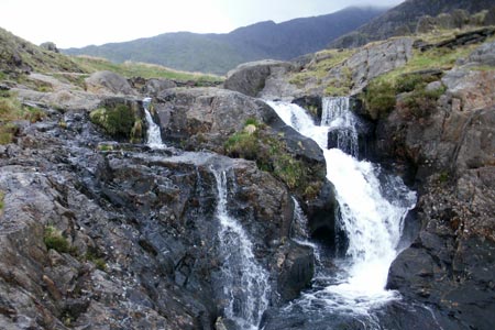
This Snowdonia walk starts at the car park at Bethania in Nantgwynant and heads up the Watkin Path across the road through woodland, the starting point of one of several routes up Snowdon. The path leads up through the trees, where horned goats may be seen, before emerging into the open. Continue along the Watkin Path as it goes to the left and then right past some waterfalls before leading to a valley with Snowdon ahead and Yr Aran to the left. Here a path leads off to the left and takes you up to the Bwlch Cwm Llan, the route becoming steeper and rockier as the bwlch draws nearer. At the bwlch (grid ref. SH605521), an even steeper path heads up Snowdon to the right. Ahead lie slate wastes and the remains of former quarry workings including a couple of small reservoirs. A walk across to the other side of the bwlch reveals a fine view of the Nantlle Ridge.
Looking towards Yr Aran from the bwlch, there appears to be no easy way up to the top. However, by following the dry stone wall ahead, a wooden stile over the wall marks a point where a clear path begins and which leads you all the way to the summit. The summit ridge is grassy with a few outcrops of rock, on one of which is a small pile of stones which marks the highest point. For the return route, by way of variation, descend down the steep rocky path to where the path forms "an elbow", but instead of turning left here to reverse the outgoing route, go straight ahead to follow a different path which broadly follows the line of a dry stone wall to the right. This path eventually disappears, but by now the Watkin Path can be seen below and it is a case of picking your own safe passage down steep, grassy, pathless slopes to rejoin it. Then follow the Watkin Path back down to the car park.
Other walks nearby
| Walk 3058 | Llyn yr Adar & Llyn Edno from near Bethania | moderate | 9.0 miles |
| Walk 1427 | Craflwyn circular from near Beddgelert | easy/mod | 2.5 miles |
| Walk 2150 | Llyn Dinas and Cwm Bychan from Beddgelert | easy/mod | 6.0 miles |
| Walk 2560 | Moel Hebog, Moel yr Ogof & Moel Lefn from Beddgelert | mod/hard | 6.5 miles |
| Walk 1799 | Moel Hebog | moderate | 5.5 miles |
| Walk 1988 | Beddgelert, Moel Hebog, Meol yr Ogof & Moel Lefn | mod/hard | 6.8 miles |
| Walk 3074 | Mynydd Sygun | moderate | 4.5 miles |
| Walk 3231 | Moel Hebog, Meol yr Ogof and Moel Lefn from Beddgelert | mod/hard | 6.8 miles |
| Walk 1426 | Aberglaslyn and Cwm Bychan | easy/mod | 5.8 miles |
| Walk 1089 | Snowdon by the Pyg and Miner's Tracks | moderate | 7.5 miles |
Recommended Books & eBooks
The Wales Coast Path
 A single guidebook to walking the whole Wales Coast Path - 1400km (870 miles) the length of Wales from Chester to Chepstow, including Anglesey, described in 57 stages. The route passes through the Snowdonia and Pembrokeshire National Parks and many AONBs and can be linked with the Offa's Dyke Path for a complete circuit of Wales.
More information
Snowdonia: 30 Low-level and easy walks - South
 Guidebook describing 30 walks in Snowdonia, Wales. Routes are mostly low level and on clear paths and showcase the region's beautiful scenery and rich history and culture. Part of a 2-volume set, this southern volume includes Trawsfynydd, Bala, Dolgellau, Machynlleth, the Harlech Coast and the valleys of the Mawddach and Dyfi.
More information
Messaging & Social Media
Message Walking Britain and follow the latest news.

Mountain Weather
Stay safe on the mountains with detailed weather forecasts - for iOS devices or for Android devices.