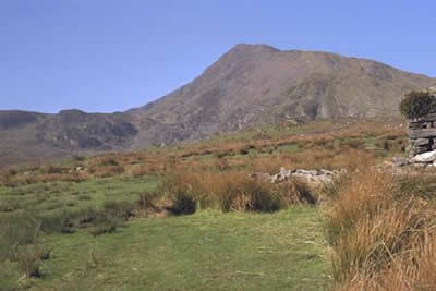
Moel Siabod from Pont Cyfyng
Snowdonia/Eryri Walk
Nat Park - Snowdonia - Moelwyns Moel Siabod Cnicht
County/Area - Conwy
Author - Lou Johnson
Length - 5.5 miles / 8.9 km Ascent - 2400 feet / 727 metres
Time - 5 hours 10 minutes Grade - hard
Maps 

| Ordnance Survey Explorer OL17 | Sheet Map | 1:25k | BUY |
| Anquet OS Explorer OL17 | Digital Map | 1:25k | BUY |
| Ordnance Survey Landranger 115 | Sheet Map | 1:50k | BUY |
| Anquet OS Landranger 115 | Digital Map | 1:50k | BUY |
Walk Route Description
Click image to visit gallery of 4 images.
Moel Siabod is a solitary mountain, separated from all the other high peaks of northern Snowdonia (Eryri) and standing in its own space to the south-west of Capel Curig. In theory Moel Siabod should demand more attention from passers-by, but its lack of shapely proportions make it a non-starter in the scenery stakes to the more majestic outlines of the Snowdon massif, the Glyders and the Carneddau. However despite its outward shortcomings, Moel Siabod is worth the attention if every dedicated mountain walker.
Parking is available on either side of the A5 at Pont Cyfyng (grid ref. SH 735571) although on busy days you may have to park elsewhere in the vicinity. Cross to the western side of the A5 road and head towards Capel Curig. On your left there is good view of the Cyfyng Falls which are spectacular after heavy rain. Turn left over the river along the lane. After a short way a track turns off right. Follow this as it gains height to Rhos farm. Like many farms throughout the UK there have obviously been problems with walkers and everyone is asked to respect the land and his livestock.
Once past the farm you have a good view of Moel Siabod and reaching a ladder stile you head along the northern shores of a pleasant reservoir presumably built when the slate quarries were in operation. Climbing once more you past through the remains of mine buildings and the plies of waste slate. The path is clear and generally good although just past the quarry buildings it does deteriorate for a short while. Climbing to a col Llyn y Foel comes into view and the path crosses a boggy section, which can be partly avoided by keeping well to the right.
Ahead you can see the eastern ridge of Moel Siabod. This is a fine rock scramble involving around 800 feet of ascent. Although never difficult with easy alternatives throughout it can be a very tiring section of this walk. Eventually the summit is reached and from here there are excellent all-round views over much of northern Snowdonia (Eryri) with Snowdon itself dominating your thoughts. The return to your car is best achieved by taking the north-east ridge which leads you unerringly back to the ladder stile encountered on the outward journey. All that is left is an easy stroll downhill back to the main road.
Other walks nearby
| Walk 3005 | Clogwen | easy | 2.0 miles |
| Walk 2766 | Capel Pinnacle / Y Pincin | easy | 1.0 miles |
| Walk 2902 | Creigiau Gleision & Llyn Cowlyd from Capel Curig | moderate | 9.5 miles |
| Walk 2200 | Eastern Carneddau | moderate | 8.5 miles |
| Walk 2300 | Glyder Fach | mod/hard | 11.5 miles |
| Walk 1661 | Crimpiau | easy/mod | 4.5 miles |
| Walk 3402 | Moel Siabod circular from Pont Cyfyng | moderate | 6.5 miles |
| Walk 1332 | Gwydir ForestLakes from Tyn Llwyn | easy/mod | 6.5 miles |
| Walk 2285 | Llyn Geirionydd & Llyn Crafnant | easy/mod | 5.5 miles |
| Walk 2592 | Llyn Geirionydd & Llyn Bychan from Llyn Crafnant | moderate | 9.5 miles |
Recommended Books & eBooks
Mountain Walking in Snowdonia
 Guidebook to 40 of Snowdonia's best day walks, with routes up Snowdon and Tryfan, including the Snowdon Horseshoe, Cadair Idris, Y Garn and The Rhinogs. The routes range from Grade 1 scrambles like Crib Goch or Bristly Ridge, to riverside and forest walks. Includes details of a 2-day traverse of all 15 of Snowdonia's 3000ft peaks.
More information
Snowdonia: 30 Low-level and easy walks - South
 Guidebook describing 30 walks in Snowdonia, Wales. Routes are mostly low level and on clear paths and showcase the region's beautiful scenery and rich history and culture. Part of a 2-volume set, this southern volume includes Trawsfynydd, Bala, Dolgellau, Machynlleth, the Harlech Coast and the valleys of the Mawddach and Dyfi.
More information
Messaging & Social Media
Message Walking Britain and follow the latest news.

Mountain Weather
Stay safe on the mountains with detailed weather forecasts - for iOS devices or for Android devices.