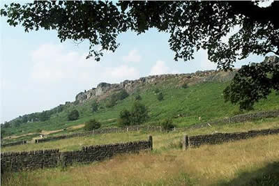
Baslow Edge & Wellington's Monument from Curbar
Peak District Walk
Nat Park - Peak District - Gritstone Edges Higger Tor
County/Area - Derbyshire
Author - Lou Johnson
Length - 3.5 miles / 5.7 km Ascent - 450 feet / 136 metres
Time - 2 hours 10 minutes Grade - easy
Maps 

| Ordnance Survey Explorer OL24 | Sheet Map | 1:25k | BUY |
| Anquet OS Explorer OL24 | Digital Map | 1:25k | BUY |
| Ordnance Survey Landranger 119 | Sheet Map | 1:50k | BUY |
| Anquet OS Landranger 119 | Digital Map | 1:50k | BUY |
Walk Route Description
Click image to visit gallery of 4 images.
Many of the walks featured in this site are only suitable for the experienced mountain walker. This short Peak District walk is an ideal introduction to the gritstone edges of the Peak District and can easily be completed in a couple of hours. There is a small car park (grid ref. SK261747) sited just back from Baslow Edge on the lane that climbs east out of Curbar towards the A621 Baslow to Sheffield main road. Alternatively you can park on the roadside in the immediate vicinity.
Even before you start you get a good idea of what the walk will be like. The views to the west are open with the River Derwent meandering through the valley below. The walk is much easier to complete than to describe so please bear with me if the description seems rather complex! From the car park head west down the lane towards Curbar village for a few hundred metres. On the left is a footpath sign pointing south. In reality there are a number of parallel paths and follow one of these in the direction of Baslow village for nearly a kilometre. Ignore the path veering right towards the Edge and go through the gate, following the path which crosses meadows to eventually pick up a track leading to Lady Wall Well.
There is a trough on your left and just after this turn left up a track, taking a left fork shortly afterwards. This leads upwards to reach the boundary of "Open Country" to pass a quarry. Quite quickly you are on the Edge with the moorland plateau stretching east towards Sheffield. Wellington's Monument is a local landmark and it has been in view from just before the quarry. From here there are good views south towards Chatsworth and beyond. After taking in the view turn around and head north using the path that follows the Edge, ignoring any path on your left that descends off the Edge. After a pleasant stroll on level ground you are soon back at your car.
Other walks nearby
| Walk 1240 | Curbar, Froggatt & White Edges | easy/mod | 8.0 miles |
| Walk 1014 | Coombs Dale, Longstone Edge & Pilsley from Calver | moderate | 10.0 miles |
| Walk 1273 | Burbage Rocks & Padley Gorge from Hay Wood | moderate | 11.0 miles |
| Walk 2515 | The River Derwent, Curbar, Baslow & Froggatt Edges | easy/mod | 7.5 miles |
| Walk 2520 | Higger Tor & the Longshaw Estate | moderate | 9.0 miles |
| Walk 1539 | Flask Edge and Bar Brook Moor from Shillito Wood | moderate | 9.4 miles |
| Walk 1093 | Higger Tor & Burbage Rocks | easy/mod | 5.3 miles |
| Walk 3557 | Chatsworth Park from Calton Lees | easy/mod | 6.5 miles |
| Walk 3018 | Cracknowl and the Monsal Trail | easy | 3.5 miles |
| Walk 2548 | Stanage Edge from Hathersage | moderate | 8.5 miles |
Recommended Books & eBooks
Dark Peak Walks
 Guidebook to 40 walks in the Dark Peak area of the Peak District National Park. 35 circular routes for most abilities, from 8km to 19km, around Edale, Marsden, Fairholmes, Baslow and Castleton, including Kinder Scout and Mam Tor, and 5 longer (25km to 45km) routes highlighting the best of the Gritstone Edges, High Moorland and Deep Valleys.
More information
Walking in the Peak District - White Peak East
 Guidebook describing 42 half-day and day walks in the limestone landscapes of Derbyshire's White Peak, part of the Peak District National Park. One of two volumes, this book covers the east of the region, with potential bases including Bakewell, Eyam, Castleton, Birchover, Matlock and Wirksworth.
More information
Messaging & Social Media
Message Walking Britain and follow the latest news.

Mountain Weather
Stay safe on the mountains with detailed weather forecasts - for iOS devices or for Android devices.