Walk 1198 - printer friendly version
Hadrian's Wall & Steel Rigg Walk
Author - Lou Johnson
Length - 8.0 miles / 13 km
Ascent - 1250 feet / 379 metres
Grade - moderate
Start - OS grid reference NY750676
Lat 55.002336 + Long -2.3923623
Postcode NE47 7AW (approx. location only)
Hadrian's Wall is one of the great monuments to the Roman Occupation of Britain. Had it not been for subsequent inhabitants of the area using the wall as an easy source of building stone, there might have been at least some sections that retained their original height. However despite this "vandalism", enough remains to give visitors an excellent idea of what this northern outpost of the Roman Empire was actually like.
First of all a warning! This should be an easy walk but it does involve a considerable amount of ascent/descent and requires much more energy than you might think! Apart from the immediate area around Housesteads, which was quite busy, there were few people on the route and you could enjoy the Wall at leisure.
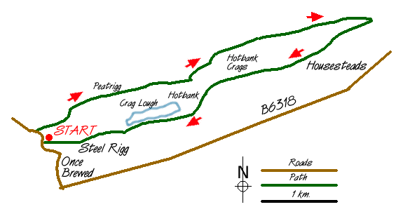
Park at the Steel Rigg car park (grid ref. NY750676). Return to the lane and turn right. After a short way there is a signed footpath on the right and you need to follow this right of way as it crosses fields past Peatrigg and Long Side to reach a path junction just north of Hotbank Farm. Follow the farm track a short way northeast before waymarks lead you on across more fields towards a small plantation (easiest route is around it rather through it as waymarked!) to reach the Wall at King's Wicket (grid ref.NY798694).
With the easiest section behind you, the switchback route now follows the Wall back to Steel Rigg car park for a distance of approximately four miles. This section is some of the best preserved and does benefit from including Vercovicium Fort (Housesteads) en-route. There are many better qualified people to inform you of the details of the Wall but suffice to say it is very impressive. The remains (mostly foundations) at Housesteads are remarkable with much to see and investigate. As you walk perhaps you should try to imagine what it was like to be stationed here in winter after enjoying the Mediterranean warmth of Italy!
Leaving Housesteads the route switchbacks up and down as it follows the most advantageous contours of the natural escarpment. I particularly liked the section along the crest of Hotbank Crags and the final stretch above Crag Lough and along Peel Crags. Both these sections are very enjoyable and enable you to get a feel for the area besides enjoying the history.
In conclusion this walk is a must for anyone visiting Northumberland ... if only history was as interesting at school!
Messaging & Social Media
Message Walking Britain and follow the latest news.

Mountain Weather
Stay safe on the mountains with detailed weather forecasts - for iOS devices or for Android devices.