Walk 1238 - printer friendly version
Hay Bluff & Twmpa Circular Walk
Author - Lou Johnson
Length - 6.0 miles / 9.8 km
Ascent - 1390 feet / 421 metres
Grade - moderate
Start - OS grid reference SO239373
Lat 52.028869 + Long -3.1106221
Postcode HR3 5RJ (approx. location only)
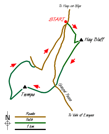
The Black Mountains form the eastern sector of the Brecon Beacons National Park and provide excellent walking with high ridges and superb edges. This walk starts from the parking area (grid ref. SO239373) at the foot of Hay Bluff and in a relatively short distance offers a taste of what can be achieved in this area.
From the parking area the first objective, Hay Bluff a steep escarpment, can be easily seen. The ascent begins across grass aiming for the rising path that can be seen on the face of the escarpment. The going is steep in places but you gain height surprisingly quickly with ever improving views over the Wye Valley to the hills and mountains of mid-Wales. Reaching the transverse path turn left and continue until you locate another path that goes sharp left. This leads without any problem to the summit of Hay Bluff, which is marked by a trig point.
After taking in the view head south west following the clear path along the edge. It is boggy in places so good footwear is essential. Ahead and across the intervening col you can see the next objective, Twmpa or Lord Hereford's Knob. Descending to reach the road at Gospel Pass you climb steeply at first before the gradient eases for an easy ascent to the summit of Twmpa. A small cairn marks the top and there are good views in most directions.
Descend from Twmpa's summit southwest towards to Rhos Dirion, the next peak along the edge. As soon as the path levels off look out for a clear path that comes in from the left. Turn down this path descending onto the grassland at the bottom of the edge. Continue to the boundary fence (grid ref. 220356) where you join a clear track. This track heads northwest before swinging southeast to join a metalled lane. Turn right along this quiet lane to cross a ford and continue northeast to reach the parking area after just over a mile.
Messaging & Social Media
Message Walking Britain and follow the latest news.

Mountain Weather
Stay safe on the mountains with detailed weather forecasts - for iOS devices or for Android devices.