Buckden Pike from Buckden
Yorkshire Dales Walk
Nat Park - Yorkshire Dales - Upper Wharfedale
County/Area - North Yorkshire
Author - Lou Johnson
Length - 10.5 miles / 17.1 km Ascent - 1900 feet / 576 metres
Time - 7 hours 10 minutes Grade - moderate
Maps 

| Ordnance Survey Explorer OL30 | Sheet Map | 1:25k | BUY |
| Anquet OS Explorer OL30 | Digital Map | 1:25k | BUY |
| Ordnance Survey Landranger 98 | Sheet Map | 1:50k | BUY |
| Anquet OS Landranger 98 | Digital Map | 1:50k | BUY |
Walk Route Description
Click image to visit gallery of 6 images.
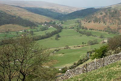
This is a Yorkshire Dales walk of many contrasts. The route begins and ends in Wharfedale with green fields dotted with barns. The middle section is in total contrast, crossing wild moorland with big skies and extensive views. Despite climbing to 702 metres above sea level, the gradients are never severe and the walking is relatively easy. There are some sections of path that are boggy after rain but all are avoidable.
The start is the large carpark in Buckden (Grid ref. 942773). After parking take the northern exit and follow the track rising through Rakes Wood to join Buckden Rake. This is followed to the first path junction. Signed to 'Buckden Pike', turn right to continue the steady climb towards Buckden Pike. There are a couple of false alarms that the summit is in sight, but generally the ascent is easy and well graded. The path makes steady progress across Cow Close before swinging southeast to reach the summit.
Adorned with a pile of stones and a concrete trig point, the summit is rather boring. However it does provide a grandstand view of the surrounding peaks. Leave the summit by following the watershed wall south to reach the memorial cross to the Polish aircrew that lost their lives in 1942. After a short distance the path from Walden Head comes in from the left which continues as Walden Road down to Starbotton. This route can be used if you are short of time. However having gained high ground it is more rewarding to stay on the ridge and follow the wall southwards.
Reaching Tor Mere Top the path does a dog leg to descend to the Starbotton Road at Cam Head. Turn left and follow this track as it descends through Sandy Gate to become Starbotton Cam Road. The descent into the village of Starbotton is quick and easy.
Locate the main valley road and turn left towards Kettlewell. Just on the edge of the village there is a footpath on your right. Take this to reach a footbridge over the River Wharfe. Turn right and follow the Dales Way towards Buckden. Reaching Dub's Lane, turn right into Buckden and the end of the route.
Other walks nearby
| Walk 1926 | Pen-y-ghent & Littondale | hard | 16.0 miles |
| Walk 1250 | Great Whernside | moderate | 8.0 miles |
| Walk 1277 | Starbotton & Kettlewell circular | easy/mod | 5.0 miles |
| Walk 1294 | Arncliffe & Kettlewell Circular | moderate | 7.0 miles |
| Walk 1632 | Arncliffe & Starbotton from Kettlewell | moderate | 7.0 miles |
| Walk 1278 | Cosh & Foxup | easy/mod | 6.5 miles |
| Walk 2332 | Mastilles Lane & Bordley from Kilnsey | easy/mod | 6.8 miles |
| Walk 3392 | Darnbrook Fell & Fountains Fell | moderate | 6.4 miles |
| Walk 2265 | Semer Water, Stalling Busk & Marsett | easy | 4.0 miles |
| Walk 3301 | Conistone to Grassington via the Dib | easy | 5.0 miles |
Recommended Books & eBooks
Trail and Fell Running in the Yorkshire Dales
 Guidebook to 40 of the best trail and fell runs in the Yorkshire Dales National Park. Ranging from 5 to 24 miles, the graded runs start from bases such as Ribblehead, Dent, Sedbergh, Malham and Grassington and take in the region's diverse delights, from castles and waterfalls to iconic mountains such as Whernside, Ingleborough and Pen Y Ghent.
More information
Walking in the Yorkshire Dales: South and West
 Part of a two-book set, this guidebook describes 44 walks in the southern and western Yorkshire Dales, including the famous 23 mile Three Peaks circuit over Pen-y-Ghent, Whernside and Ingleborough. The other, mostly circular routes of 3½ to 13 miles cover the scenic region between Sedbergh, Kirkby Lonsdale, Settle, Skipton and Grassington.
More information
Messaging & Social Media
Message Walking Britain and follow the latest news.

Mountain Weather
Stay safe on the mountains with detailed weather forecasts - for iOS devices or for Android devices.