The Fauld Crater from Hanbury
Staffordshire Walk
County/Area - Staffordshire - Mid Staffordshire
Author - Lou Johnson
Length - 1.7 miles / 2.8 km Ascent - 60 feet / 18 metres
Time - 1 hours 0 minutes Grade - easy
Maps 

| Ordnance Survey Explorer 245 | Sheet Map | 1:25k | BUY |
| Anquet OS Explorer 245 | Digital Map | 1:25k | BUY |
| Ordnance Survey Landranger 128 | Sheet Map | 1:50k | BUY |
| Anquet OS Landranger 128 | Digital Map | 1:50k | BUY |
Walk Route Description
Click image to visit gallery of 6 images.
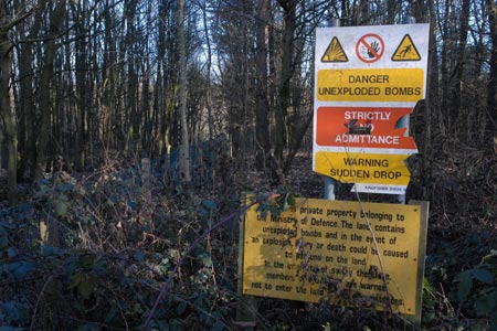
This short walk visits the crater left after one of the largest non-nuclear explosions in history. The explosion took place on 27th November 1944 when as much as 4,000 tonnes of high explosive stored underground was detonated killing some 90 people. The crater measured 400 feet (120 metres) deep and some 1400 yards (1200 metres) across. Despite the passage of time and the growth of vegetation the site is still an impressive feature of the Staffordshire countryside.
The start for this walk is the car park of Cock Inn at Hanbury (grid ref. SK173278). Please note that you should only park with the publican's permission and perhaps obtain refreshments at the end of the walk. After parking turn left out of the car park and take the signed footpath almost immediately on the left. This leads through fields towards Tutbury.
At the first junction of paths continue ahead on the path to Tutbury. This leads you across fields to Brown's Coppice. Enter this woodland (grid ref. SK180280) and immediately turn right. You soon arrive at the crater which is surrounded by high fences which are liberally decorated with warning notices. Continue along the fence passing a memorial to the explosion, which details the events of that fateful day in 1944.
To continue the walk stay on the footpath as it curves left around the crater. At grid reference SK182275 the path goes right and continues to a junction of paths. Go right here and follow the path with a hedge on your left. Reaching another junction (grid ref. SK178273), go left. This leads you up to a track. Continue along this track back to the road. Turn right and the Cock Inn is a little way along on the right.
If you require a longer walk then this route can be combined with Walk 1711 to make a figure of eight route walk.
Other walks nearby
| Walk 3405 | Abbots Bromley Circular | easy | 6.0 miles |
| Walk 1375 | Blithfield Estate Circular | easy | 2.5 miles |
| Walk 1608 | Calke Abbey & Robin Wood from Ticknall | easy/mod | 8.0 miles |
| Walk 1843 | Haywood Slade & Sherbrook from Seven Springs | easy | 4.0 miles |
| Walk 1753 | Abraham's Valley & Haywood Warren from Seven Springs | easy | 3.0 miles |
| Walk 3562 | The Weaver Hills from Wootton | easy | 3.2 miles |
| Walk 1370 | Sherbrook Valley from Punch Bowl, Milford | easy | 4.0 miles |
| Walk 1802 | Shugborough Park from Milford | easy | 4.5 miles |
| Walk 1731 | Highlights of Cannock Chase from Marquis Drive | easy/mod | 10.0 miles |
| Walk 1189 | Cannock Chase Circular | easy | 6.5 miles |
Recommended Books & eBooks
Walking in the Peak District - White Peak East
 Guidebook describing 42 half-day and day walks in the limestone landscapes of Derbyshire's White Peak, part of the Peak District National Park. One of two volumes, this book covers the east of the region, with potential bases including Bakewell, Eyam, Castleton, Birchover, Matlock and Wirksworth.
More information
Messaging & Social Media
Message Walking Britain and follow the latest news.

Mountain Weather
Stay safe on the mountains with detailed weather forecasts - for iOS devices or for Android devices.