Cnicht from Tanygrisiau
Snowdonia/Eryri Walk
Nat Park - Snowdonia - Moelwyns Moel Siabod Cnicht
County/Area - Conwy
Author - Peter Smyly
Length - 8.0 miles / 13 km Ascent - 1650 feet / 500 metres
Time - 5 hours 40 minutes Grade - moderate
Maps 

| Ordnance Survey Explorer OL17 | Sheet Map | 1:25k | BUY |
| Anquet OS Explorer OL17 | Digital Map | 1:25k | BUY |
| Ordnance Survey Explorer OL18 | Sheet Map | 1:25k | BUY |
| Anquet OS Explorer OL18 | Digital Map | 1:25k | BUY |
| Ordnance Survey Landranger 115 | Sheet Map | 1:50k | BUY |
| Anquet OS Landranger 115 | Digital Map | 1:50k | BUY |
Walk Route Description
Click image to visit gallery of 6 images.
This is essentially a linear Snowdonia (Eryri) walk, therefore it will need to be decided in advance how best to return to the walk's start point, or whether to finish somewhere else. Books about walking in Wales which feature Cnicht normally suggest the hamlet of Croesor to the south as a starting point. By way of variation, this route starts at Tanygrisiau, a village in the Vale of Ffestiniog.
While the Moelwyns generally are a little-known or frequented group of mountains to the south of the more popular Snowdon range, Cnicht is one Moelwyn which does draw walkers, due to its reputation as "the Welsh Matterhorn" based on its pyramid-like form when seen from the south west. It does not appear in this form in this walk, though you do see two very different impressions of it. When seen from the east from near to Llyn Cwm Corsiog, it shows its impressive steep eastern slopes, but when approached from near to Llyn yr Adar (The Lake of the Birds) to the north/north-east, it appears as a gentle grassy ridge. Although of relatively modest height (2,260 ft), Cnicht is likely to be on the "want to do" lists of walkers in the Welsh mountains.
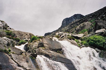
Passing though the village of Tanygrisiau, a track to the north heads past slopes of slate wastes on the right, remains of the former quarry. However, if these present a picture of grim desolation, by way of contrast, some cascades to the left of the path are very picturesque. The unsurfaced road gains height to reach the first lake, Llyn Cwmorthin, a large lake occupying a valley, but this route turns off to the left before reaching the outflow of the lake. The outflow is too wide to cross so the path must be taken.
Once it reaches the lake on the other side of the outflow, the path, an old drovers' track, follows a more or less straight course in parallel to the lake to the right along a remote valley. The waterfall to the right at the far end of the lake issues from another lake, Llyn Conglog, which is about a thousand feet higher up. The route leads diagonally uphill at the end of the lake to reach the slate wastes and former quarry workings of the Rhosydd Quarry, a desolate place. This stretch is short lived before you emerge on to grassy felllside. Cnicht by now has appeared to the left and looks higher than it is. Moelwyn Mawr dominates the view to the left with the U-shaped Croesor Valley between the two. A grassy track, wide enough to take a vehicle, skirts the hillside to the left and looks inviting but this is not the right way to go for this walk. Instead, a barely discernible path leads slightly north-east of north and Llyn Cwm Corsiog, a former quarry reservoir soon comes into view on the right.
The next stretch between here and the crest of the ridge leading to Cnicht is over mostly pathless terrain and therefore this could well be a confusing area in mist. A path does appear though as you approach the ridge. Once over the rise, Llyn yr Adar can be seen ahead with the Snowdon range beyond. Next follows a gentle walk to the left up grassy fellside to Cnicht, with a few knolls providing some variety, revealing its gentler side. This approach is much easier than the climb up from Croesor to the south and a path of sorts appears on the left with a steep slope going down to the Croesor Valley to the left and Moelwyn Mawr looming large on the other side of the Croesor valley. Cnicht appears to have two summits, two rocky knolls and it is not easy to tell initially which is the higher of the two, but the higher one is marked by a small cairn. This is a fine summit, a small rocky area with the ground going down fairly steeply on three sides and a view out to the sea to the west and Tremadog Bay.
To conclude the walk, unless you have pre-arranged for someone to collect you by car, then the options are generally:
1) Reverse the outgoing route,
2) Make the walk longer and with a greater amount of cumulative ascent by including Moelwyn Mawr and Moelwyn Bach before returning to the start point.
3) Take the opportunity to explore some of the various llyns or lakes that are in the region with the former Rhosydd Slate Quarry being another possibility to look around before returning via Llyn Cwmorthin.
Other walks nearby
| Walk 3024 | North West of Blaenau Ffestiniog | mod/hard | 8.5 miles |
| Walk 1127 | Cnicht | moderate | 6.3 miles |
| Walk 3035 | The Moelwyns | mod/hard | 7.5 miles |
| Walk 1010 | Cnicht, Moel Druman & Allt-fawr | moderate | 10.0 miles |
| Walk 1422 | Cnicht and Moelwyn Mawr | moderate | 8.0 miles |
| Walk 3058 | Llyn yr Adar & Llyn Edno from near Bethania | moderate | 9.0 miles |
| Walk 1192 | Yr Aran | mod/hard | 6.5 miles |
| Walk 1103 | Snowdon & Cwm Llan horseshoe | very hard | 13.0 miles |
| Walk 2290 | Snowdon via the Watkin Path & South Ridge from Bethania | mod/hard | 8.0 miles |
| Walk 1136 | Yr Aran (Route 2) | moderate | 5.5 miles |
Recommended Books & eBooks
Snowdonia: 30 Low-level and easy walks - North
 Guidebook describing 30 walks in Snowdonia, Wales. Routes are mostly low level and on clear paths and showcase the region's beautiful scenery and rich history and culture. Part of a 2-volume set, this northern volume includes the Snowdon area, the Ogwen and Conwy Valleys, Betws-y-Coed, Beddgelert, Ffestiniog and the coast.
More information
Great Mountain Days in Snowdonia
 Inspirational guidebook to 40 great mountain day walks and scrambles in Snowdonia. Inspirational routes for all abilities across the National Park with routes up Snowdon and Moel Eilio, the Glyderau, the Carneddau, Eifionydd, Siabod and the Moelwynion, Rhinogydd (the Harlech Dome), Migneint and the Arans and Cadair Idris and the Tarrens.
More information
Messaging & Social Media
Message Walking Britain and follow the latest news.

Mountain Weather
Stay safe on the mountains with detailed weather forecasts - for iOS devices or for Android devices.