The Arans from Cwm Cywarch
Snowdonia/Eryri Walk
Nat Park - Snowdonia - Arans Lake Bala
County/Area - Gwynedd
Author - Stephen Starkey
Length - 14.0 miles / 22.8 km Ascent - 4500 feet / 1364 metres
Time - 11 hours 30 minutes Grade - hard
Maps 

| Ordnance Survey Explorer OL23 | Sheet Map | 1:25k | BUY |
| Anquet OS Explorer OL23 | Digital Map | 1:25k | BUY |
| Ordnance Survey Landranger 124 | Sheet Map | 1:50k | BUY |
| Anquet OS Landranger 124 | Digital Map | 1:50k | BUY |
Walk Route Description
Click image to visit gallery of 6 images.
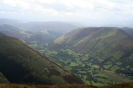
Cwm Cywarch is one of Wales' hidden gems. As far as roads are concerned, it is a valley to nowhere, but none the less, it is a beautiful valley. It's location away from the main Snowdonia (Eryri) ranges also mean it is a much quieter area to enjoy a day in the hills. For many years, access to the Arans for walkers was a very sensitive issue with local landowners. The advent of the CRoW Act has helped a little but the issue is still sensitive. Please take extra care if walking in this area (particularly if venturing away from the marked public footpaths) to behave in a responsible manner so as not to jeopardise access to this beautiful area. Parking is at the head of the valley in a signed car park (grid ref. SH852188).
Having contributed a few walks to Walking Britain I decided it was about time I followed a walk submitted by somebody else. It didn't quite work out like that in the end - hence this route description. However, the inspiration for this walk came from walk 1190 which offers a shorter variation to this route. The main reason I had for extending the route was to be able to bag more SNOTTs (SNOwdonian Two Thousand foot peaks).
From the parking area (grid ref. SH853184) you will see two obvious tracks to the West of the road. This route starts out by following the path that heads SSW from the road for about 160m before turning right (WNW) on a public footpath. After passing the farm buildings at Gesail the path veers round to the SW and starts to climb quite steeply on the Western shoulder of Cwm yr Ychen. As the path climbs, the route becomes more obvious as the path follows an old miners track zig-zagging its way up the hill.
On reaching the first plateau, the path heads West and converges on a fence that runs basically East - West. When the path crosses this fence, leave the path and continue slightly N of W walking between the fence and the prominent steep crags.
Cross the fence that runs SW - NE by means of the small step stile then continue following the line of the fence up hill. This section is pathless across rough, wild moorland and is wet in places. When the fence takes a very obvious bend to the left (grid ref SH836188), stop following the fence and walk on a grid bearing of 002 degrees for 500m to arrive at the Eastern edge of Llyn y Fign. From the small lake it is only about 100m further to reach the summit of Glasgwm.
The summit of Glasgwm is devoid of paths but the descent route is easily followed by keeping to the right of the fence that heads initially NNE. As you descend, a number of clear sheep tracks will be found. Any of these can be followed providing you continue heading in a basically NE direction, aiming for the small tarn at grid reference 841-200. Cross the fence by means of the small shepherd step stile then take the obvious grassy path that heads NE.
This path basically follows the line of a fence heading NE. The ground is very boggy along this section though the worst areas are avoided by means of either stepping stones or duckboards. At grid ref SH851208, just after the fence kinks right then left, a faint grassy path will be seen heading off to the right. Turn right to follow the path across the boggy moorland, crossing the Camddwr stream before climbing ahead to the unmarked summit of Gwaun y Llwyni.
From the summit, the easiest option is to retrace your route back to the path left earlier. An alternative is to follow a fairly clear grassy path that follows the rim of Gwaun y Llywni to the 657m spot height before veering NW back to the main path. This option will involve fording multiple streams and the crossings are more difficult (especially if the streams are in spate) than the single crossing involved with retracing your route. Once back to the fence, turn right and follow the path NNE towards the summit of Aran Fawddwy. On the way to the summit, shortly after crossing a stile, note the path that joins from the East as this is the path required for the return route. For now though continue ahead to the trig point at the summit of Aran Fawddwy, from where the views are good but better are yet to come.
On leaving the summit, continue Northwards alongside the fence once more. Cross the secondary summit of Erw y Ddafad-ddu before pressing on for a further 1km or so to the summit of Aran Benllyn. Personally I was a little disappointed with the views from Aran Fawddwy but the spectacular all round views from Aran Benllyn certainly offset the earlier disappointment.
From Aran Benllyn, retrace your route back along the ridge to the return path noted earlier. If desired, it is possible to bypass the summits of Erw y Ddafad-ddu and Aran Fawddwy using paths slightly to the West of the summits.
At grid reference SH859220, take the left hand path that forks S to eventually walk along the crest of Aran Fawddwy's Southern ridge. At Drws Bach you will arrive at a cairn built in memory of an RAF Mountain Rescue crew man killed during a rescue call. A recent addition to the cairn has been a geocache. From the cairn there are superb views North to Aran Fawddwy and Creiglyn Dyfi, whilst to the South are views of Pen yr Allt Uchaf - the final peak of the day - and the return path.
From the cairn continue Eastwards, initially descending before climbing to the grassy, unmarked summit of Drysgol. The path then continues SE on a steady descent to the obvious col above Hengwm. At the col, continue SSE across marshy ground to the minor top of Waun Goch before following the visible track SW along the ridge to the summit of Pen yr Allt Uchaf. Although you could cut down the hillside from the summit, the slope is deceptively steep and the dense heather makes for tough going so I recommend that you retrace your route back to the col for the easiest descent.
At the col, head SW on the clear path that descends on the slopes above Hengwm. This is a rocky path but the going is quite easy apart from one very short rocky passage that is tricky in descent - and comes as a shock with the general nature of this path. After a long, gradual descent, you arrive at a wall where a path runs across our route. Turn right here then, after 55m turn left and follow the path across the footbridge to the road. Turn left (S) along the road and, in about 250m, arrive back at the car.
Other walks nearby
| Walk 2937 | Aran Fawddwy northern approach | mod/hard | 8.4 miles |
| Walk 1107 | Waun Oer and Maesglase near Dinas Mawddwy | mod/hard | 11.0 miles |
| Walk 2551 | Rhobell Fawr from near Rhydymain | moderate | 5.7 miles |
| Walk 2811 | Rhobell Fawr and Ddualt from near Rhydymain | moderate | 8.5 miles |
| Walk 1499 | Rhobell Fawr and Dduallt from Llanfachreth | moderate | 12.0 miles |
| Walk 2334 | The Torrent Walk near Dolgellau | easy | 1.6 miles |
| Walk 1646 | The Precipice Walk | easy | 3.5 miles |
| Walk 2475 | The Dyfi Hills Ridge | mod/hard | 9.8 miles |
| Walk 3017 | Aran Benllyn & Aran Fawddwy from Llanuwchllyn | mod/hard | 10.0 miles |
| Walk 2059 | Castell Carndochan near Bala | easy/mod | 2.5 miles |
Recommended Books & eBooks
The Cambrian Way
 Guidebook to the Cambrian Way, a challenging three-week mountain trek through Wales from Cardiff to Conwy. The 470km un-waymarked route is presented from south to north. Often sticking to long, beautiful ridgelines, it crosses wild and rugged terrain and visits many of Wales's highest mountains, including Snowdon.
More information
Snowdonia: 30 Low-level and easy walks - South
 Guidebook describing 30 walks in Snowdonia, Wales. Routes are mostly low level and on clear paths and showcase the region's beautiful scenery and rich history and culture. Part of a 2-volume set, this southern volume includes Trawsfynydd, Bala, Dolgellau, Machynlleth, the Harlech Coast and the valleys of the Mawddach and Dyfi.
More information
Messaging & Social Media
Message Walking Britain and follow the latest news.

Mountain Weather
Stay safe on the mountains with detailed weather forecasts - for iOS devices or for Android devices.