Aberglaslyn and Cwm Bychan from Beddgelert
Snowdonia/Eryri Walk
Nat Park - Snowdonia - Moelwyns Moel Siabod Cnicht
County/Area - Gwynedd
Author - Peter Smyly
Length - 5.8 miles / 9.3 km Ascent - 1000 feet / 303 metres
Time - 3 hours 50 minutes Grade - easy/mod
Maps 

| Ordnance Survey Explorer OL17 | Sheet Map | 1:25k | BUY |
| Anquet OS Explorer OL17 | Digital Map | 1:25k | BUY |
| Ordnance Survey Landranger 115 | Sheet Map | 1:50k | BUY |
| Anquet OS Landranger 115 | Digital Map | 1:50k | BUY |
Walk Route Description
Click image to visit gallery of 5 images.
As a relatively low level walk in Snowdonia (Eryri), this is a fine outing on a sunny day with the views especially attractive when seen in evening sunlight. It could be completed in a morning or afternoon but the amount of ascent should not be underestimated, particularly from Nantmor up to the col. The walk includes a gorge, a valley, a lake and fine views of the peaks of the Snowdon range. A visit to the Sygun Copper Mine could also be included.
From Beddgelert, follow the path by the river away from the village. The path crosses the railway line and is easy going to begin with but becomes rockier as progress is made and the sides of the valley close in to form the impression of a gorge. Although there is a road on the other side of the river, any traffic noise is drowned out by the rushing water of the river below. Some pools offer swimming opportunities for those brave enough.
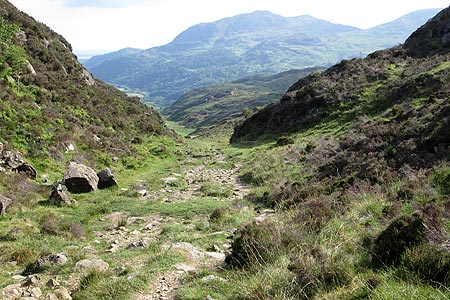
The track leads away from the river through woodland and under the railway line. Height is gained in earnest as the track emerges into the open at the Cwm Bychan valley (the same name as the Rhinogs' Cwm Bychan, but not as well-known). The path steadily gains height, levelling out in a couple of places with valley sides of heather, rocks and bilberry plants. Cnicht, Moelwyn Mawr and Moelwyn Bach are seen to the east.
Once the highest point of the valley is reached, one of the better views of the walk opens out ahead looking across to some of the better-known Snowdonia (Eryri) peaks including the Snowdon range and Moel Siabod. Shortly after the descent begins, a path junction is reached with the path to the left offering a shorter way back via either the Sygun Copper Mine of Mynydd Sygyn. Instead, for this route, follow the path ahead as it steadily loses height. Llyn Dinas appears below on the final downhill section, the path reaching the lake shore before turning left alongside the river. Return to Beddgelert via the Sygun Copper Mine, following a secondary road that goes past the Cae Du campsite and later the river.
Other walks nearby
| Walk 1427 | Craflwyn circular from near Beddgelert | easy/mod | 2.5 miles |
| Walk 3058 | Llyn yr Adar & Llyn Edno from near Bethania | moderate | 9.0 miles |
| Walk 1192 | Yr Aran | mod/hard | 6.5 miles |
| Walk 1103 | Snowdon & Cwm Llan horseshoe | very hard | 13.0 miles |
| Walk 2290 | Snowdon via the Watkin Path & South Ridge from Bethania | mod/hard | 8.0 miles |
| Walk 1136 | Yr Aran (Route 2) | moderate | 5.5 miles |
| Walk 1515 | Tops and Tarns of the Moelwyns | mod/hard | 11.0 miles |
| Walk 2590 | Nantlle Ridge Walk from Rhyd Ddu (Route A) | moderate | 6.0 miles |
| Walk 2797 | Yr Aran and Snowdon from Rhyd-Ddu | mod/hard | 8.5 miles |
| Walk 3509 | Nantlle Ridge from Rhyd Ddu (Route B) | mod/hard | 8.3 miles |
Recommended Books & eBooks
The Cambrian Way
 Guidebook to the Cambrian Way, a challenging three-week mountain trek through Wales from Cardiff to Conwy. The 470km un-waymarked route is presented from south to north. Often sticking to long, beautiful ridgelines, it crosses wild and rugged terrain and visits many of Wales's highest mountains, including Snowdon.
More information
Snowdonia: 30 Low-level and easy walks - South
 Guidebook describing 30 walks in Snowdonia, Wales. Routes are mostly low level and on clear paths and showcase the region's beautiful scenery and rich history and culture. Part of a 2-volume set, this southern volume includes Trawsfynydd, Bala, Dolgellau, Machynlleth, the Harlech Coast and the valleys of the Mawddach and Dyfi.
More information
Messaging & Social Media
Message Walking Britain and follow the latest news.

Mountain Weather
Stay safe on the mountains with detailed weather forecasts - for iOS devices or for Android devices.