Craflwyn circular from near Beddgelert
Snowdonia/Eryri Walk
Nat Park - Snowdonia - Snowdon Crib Goch
County/Area - Gwynedd
Author - Peter Smyly
Length - 2.5 miles / 4.1 km Ascent - 700 feet / 212 metres
Time - 2 hours 0 minutes Grade - easy/mod
Maps 

| Ordnance Survey Explorer OL17 | Sheet Map | 1:25k | BUY |
| Anquet OS Explorer OL17 | Digital Map | 1:25k | BUY |
| Ordnance Survey Landranger 115 | Sheet Map | 1:50k | BUY |
| Anquet OS Landranger 115 | Digital Map | 1:50k | BUY |
Walk Route Description
Click image to visit gallery of 4 images.
This is a relatively short Snowdonia (Eryri) walk that falls into the "fine views in return for minimal effort" category. For anybody who has walked up Mynydd Sygyn to the south east of Beddgelert, this is a walk on the opposite side of the valley. The distance, height gain, terrain and likely time to be taken to complete the walk are all similar.
It would be very easy to drive past the start point for this walk and not even realise that the walk exists. The walk does not reach the top of anything, though it could be reasoned that the highest point offers a balcony type view part way up a fellside. With an old railway sleeper as a "bench" it does have a bit of a "top of the hill" feel about it, given that it is nearly as high as Mynydd Sygun across the valley, though a glance behind reveals more sloping felllside. Still, the views are so good, it matters little that it is not the highest point.
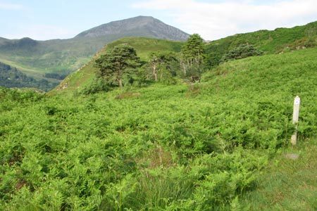
The starting point is the car park at Craflwyn which leads up through wooded slopes, branching left early on. The return route rejoins this point towards the end. The views do not open out until the path emerges from tree cover and skirts round steep rocky slopes to the right with a bit of steep ascent involved as it circles round to reach the highest point on the walk, a level grassy area on the side of the hill. However, this is a view worth stopping to look at. Across the valley, the heathery slopes of Mynydd Sygyn and Grib Ddu, which look so high when seen from valley level, are now at a similar height. To the left, a glimpse of Llyn Dinas is in view and the pyramid-like shape of Moel Siabod is seen. To the right, Moel Hebog and its satellite peaks dominate the skyline. The village of Beddgelert can also be seen below as can the Cae Du campsite ahead and below.
The descent route crosses bracken-covered felllside for some distance before starting to lose height. In places the path has been reinforced with rocks. A sizeable chair offers another viewpoint on the way down. Follow the path down through more bracken and woodland to rejoin the outgoing route.
An alternative approach is to start from Beddgelert. To do this, you can largely avoid the main road by taking the back road out to the Sygun Copper Mine, crossing a bridge over the river, then turning left along the opposite river bank to the main road where the car park is just a few minutes walk on the right.
Other walks nearby
| Walk 2150 | Llyn Dinas and Cwm Bychan from Beddgelert | easy/mod | 6.0 miles |
| Walk 2560 | Moel Hebog, Moel yr Ogof & Moel Lefn from Beddgelert | mod/hard | 6.5 miles |
| Walk 1799 | Moel Hebog | moderate | 5.5 miles |
| Walk 1988 | Beddgelert, Moel Hebog, Meol yr Ogof & Moel Lefn | mod/hard | 6.8 miles |
| Walk 3074 | Mynydd Sygun | moderate | 4.5 miles |
| Walk 3231 | Moel Hebog, Meol yr Ogof and Moel Lefn from Beddgelert | mod/hard | 6.8 miles |
| Walk 1426 | Aberglaslyn and Cwm Bychan | easy/mod | 5.8 miles |
| Walk 3058 | Llyn yr Adar & Llyn Edno from near Bethania | moderate | 9.0 miles |
| Walk 1192 | Yr Aran | mod/hard | 6.5 miles |
| Walk 1103 | Snowdon & Cwm Llan horseshoe | very hard | 13.0 miles |
Recommended Books & eBooks
The Wales Coast Path
 A single guidebook to walking the whole Wales Coast Path - 1400km (870 miles) the length of Wales from Chester to Chepstow, including Anglesey, described in 57 stages. The route passes through the Snowdonia and Pembrokeshire National Parks and many AONBs and can be linked with the Offa's Dyke Path for a complete circuit of Wales.
More information
Great Mountain Days in Snowdonia
 Inspirational guidebook to 40 great mountain day walks and scrambles in Snowdonia. Inspirational routes for all abilities across the National Park with routes up Snowdon and Moel Eilio, the Glyderau, the Carneddau, Eifionydd, Siabod and the Moelwynion, Rhinogydd (the Harlech Dome), Migneint and the Arans and Cadair Idris and the Tarrens.
More information
Messaging & Social Media
Message Walking Britain and follow the latest news.

Mountain Weather
Stay safe on the mountains with detailed weather forecasts - for iOS devices or for Android devices.