Sychnant Pass, Alltwen, Penmaen-Bach, & Conwy Mountain
Snowdonia/Eryri Walk
Nat Park - Snowdonia - Eastern Carneddu
County/Area - Conwy
Author - Alwyn Williams
Length - 3.0 miles / 4.9 km Ascent - 900 feet / 273 metres
Time - 2 hours 20 minutes Grade - easy/mod
Maps 

| Ordnance Survey Explorer OL17 | Sheet Map | 1:25k | BUY |
| Anquet OS Explorer OL17 | Digital Map | 1:25k | BUY |
| Ordnance Survey Landranger 115 | Sheet Map | 1:50k | BUY |
| Anquet OS Landranger 115 | Digital Map | 1:50k | BUY |
Walk Route Description
Click image to visit gallery of 4 images.
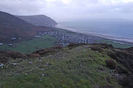
The Snowdonia (Eryri) walk starts from the lay by on the Sychnant Pass at Grid Ref SH749769. From the western end of the lay by follow the single track lane uphill for approx 150 meters. When the lane turns sharp right follow the path up the steep, short climb to the summit of Alltwen SH745774.
From the summit of Alltwen, take time to savour the views. To the West you can see the coastline of Eastern Anglesey and Puffin Island. To the East you can see the Great Orme, Llandudno and Conwy. To the South you can see the gentle slopes of the Eastern Carneddau range. On a clear day you might also be able to see the distant coastline of the Isle of Man on the horizon.
Head off the summit of Alltwen in a Northerly direction following the path which will lead you towards the summit of Penmaen-Bach. The going is fairly easy here on an easy to follow path which heads past the side wall of a field at grid ref SH746776. From here the path goes slightly uphill towards a slope of scree. You can follow the path which winds its way around the top of the summit or you can do as I did and follow an easy scramble up to the summit of Penmaen-Bach SH748780.
From the summit of Penmaen-Bach follow the faint path in a Southerly direction and pass the side wall of a field SH749775. From here the path becomes quite easy to follow and within around 200m it crosses the North Wales Path. At this point turn left to follow the North Wales Path to the Summit of Conwy Mountain.SH760778.
From the Summit of Conwy Mountain there are more impressive view of the Irish Sea, Conwy and the Eastern Carneddau. Head back along the North Wales Path in a Westerly direction back towards the starting point. At grid ref SH750774 there is a little stream that needs to be forded before the path joins the access road to Pen Pyra farm. Follow this access road down hill back to the car park from where the walk started.
Other walks nearby
| Walk 2497 | Druid Circle, Moelfre and Foel Lus from Penmaenmawr | easy/mod | 6.0 miles |
| Walk 3061 | Eastern Carneddau from near Rowen | mod/hard | 10.5 miles |
| Walk 2547 | Carnedd Llewelyn from near Rowen | mod/hard | 12.0 miles |
| Walk 1915 | Great Orme & Country Park from Llandudno | easy/mod | 7.0 miles |
| Walk 2072 | Great Orme & Country Park, Llandudno (short route) | easy/mod | 4.0 miles |
| Walk 2346 | Yr Orsedd ridge from near Bont Newydd | moderate | 4.8 miles |
| Walk 3020 | Aber Falls, Foel-fras & Drum | mod/hard | 9.0 miles |
| Walk 3021 | Northern Carneddau | mod/hard | 12.0 miles |
| Walk 1635 | Garnedd Uchaf & Llyn Eigiau | mod/hard | 9.0 miles |
| Walk 2542 | Foel Grach & Llyn Eigiau | moderate | 8.5 miles |
Recommended Books & eBooks
The Cambrian Way
 Guidebook to the Cambrian Way, a challenging three-week mountain trek through Wales from Cardiff to Conwy. The 470km un-waymarked route is presented from south to north. Often sticking to long, beautiful ridgelines, it crosses wild and rugged terrain and visits many of Wales's highest mountains, including Snowdon.
More information
Great Mountain Days in Snowdonia
 Inspirational guidebook to 40 great mountain day walks and scrambles in Snowdonia. Inspirational routes for all abilities across the National Park with routes up Snowdon and Moel Eilio, the Glyderau, the Carneddau, Eifionydd, Siabod and the Moelwynion, Rhinogydd (the Harlech Dome), Migneint and the Arans and Cadair Idris and the Tarrens.
More information
Messaging & Social Media
Message Walking Britain and follow the latest news.

Mountain Weather
Stay safe on the mountains with detailed weather forecasts - for iOS devices or for Android devices.