Walk 1475 - printer friendly version
Bunster Hill and Dovedale from Ilam Walk
Author - Lou Johnson
Length - 4.5 miles / 7.3 km
Ascent - 1300 feet / 394 metres
Grade - easy/mod
Start - OS grid reference SK135508
Lat 53.054288 + Long -1.800043
Postcode DE6 2AZ (approx. location only)
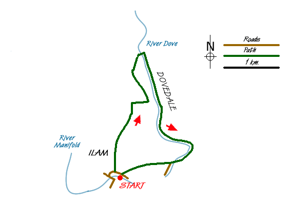
This Peak District walk starts from the village of Ilam and takes a high level route along the western rim of Dovedale to Ilam Rock. The route then descends into Dovedale and follows this well known river downstream. The walk offers some fine views typical of the White Peak and the limestone dales of Staffordshire and Derbyshire
The start is near the centre of Ilam village (grid ref SK135508) where on street parking is usually available. If not there is pay and display parking alongside Ilam Hall. After parking walk east along the road towards Thorpe. Just past the last building go over the stile on the left. Ignore the main path to Dovedale, instead walk north on a less obvious path that climbs across the western flank of Bunster Hill. The right of way crosses the field on your left but there is no need to follow this. Just continue walking uphill with the field boundary on your left. Ignore the path leading to Ilammoor Lane and continue alongside the field boundary to reach a stile (Grid ref. SK139520). Cross the stile and field to enter a walled lane with trees.
Turn right to Air Cottage as you reach Ilamtops Farm and continue to follow the waymarked route around the back of Air Cottage. The onward path follows the western rim of Dovedale and you get some good views into the dale and across to the other side. The route is well signed and eventually you begin to descend into Dovedale. The path zigzags down to reach the banks of the River Dove below Ilam Rock. Turn right, cross the River Dove using the footbridge and once on the other side follow the river downstream (right). Despite walking downstream there is still some ascent to complete on the section up to Lover's Leap.
It is likely, especially in fine weather, for this section to be very busy. However you can still admire the dramatic gorge through which the river flows. Quite soon the shapely outline of Thorpe Cloud comes into view. Arriving at the stepping stones (Grid ref. SK151514), stay on the eastern bank continuing downstream until you reach a footbridge. Cross this and walk along the lane. Reaching the entrance to the car parks on both sides of the lane, turn right into the car park and walk parallel with the lane to take the signed path on your right across fields and down to a lane in Ilam. Turn right along the lane back to the centre of the village.
Messaging & Social Media
Message Walking Britain and follow the latest news.

Mountain Weather
Stay safe on the mountains with detailed weather forecasts - for iOS devices or for Android devices.