WHW - Day 1 - Milngavie to Drymen
East Dunbartonshire Walk
County/Area - East Dunbartonshire & Stirling
Author - Peter Smyly
Length - 12.0 miles / 19.5 km
Ascent - nominal or unknown
Time - 6 hours 0 minutes Grade - moderate
Maps 

| Ordnance Survey Explorer 348 | Sheet Map | 1:25k | BUY |
| Anquet OS Explorer 348 | Digital Map | 1:25k | BUY |
Walk Route Description
Click image to visit gallery of 3 images.
This stage is generally regarded as a warm-up and the distance is the shortest of the six days with no significant height gain and ground may be covered relatively quickly. This is an advantage if setting off mid-afternoon having travelled up by train from the deep south earlier in the day. The Glasgow commuter town of Milngavie (pronounced Mullguy), with its distinctive WHW granite obelisk is the official starting point but the route quickly assumes a more rural nature as it passes by a stream, Allander Water, through parkland and woods.
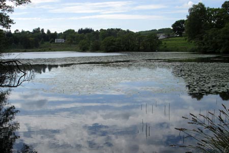
A short rise up a hill at Allander Park offers a last glimpse of the houses of Milngavie before they disappear from view. The route passes through Mugdock Wood before a road crossing and Craigallian Loch, backed by woods, soon appears on the right. The serene lake of Carbeth Loch, with its reeds and water lilies, appears next on the left, followed by a few hundred metres of road walking at Easter Carbeth. The WHW leaves the road on the right and the dome-shaped, steep-sided grassy hill of Dumgoyne appears on the skyline ahead and this landmark remains in view for much of the rest of Day 1, seen from near and far. Rather than an isolated hill top, it turns out to be part of a range of hills, as can be seen as the walk progresses.
The WHW descends briefly at Arlehaven to pass another dome-shaped hill, the wooded Dumgoyach. This is pleasant countryside walking on a bright sunny day. On a clear day, Scotland's most southerly Munro, Ben Lomond, can be glimpsed afar, a reminder that this peak overlooks Rowardennan which will be reached on day 2. Next the route runs along an old railway line after Dumgoyach Bridge to pass the Beech Tree Inn at the village of Dumgoyne. It then runs closely in parallel to the busy A81 before crossing it to follow a minor road which crosses a river at a bridge at the houses of Gartness. A little further along the road, cows could be seen grazing on a hill ridge above gorse-covered slopes to the right, a pastoral scene. Most of the remainder of Day 1 passes along this minor road as far as Drymen. A first distant glimpse of Loch Lomond is seen to the left. A path up a grassy hill off-road to the right connects with Striling Road, leading to Drymen which is slightly off-route from the WHW and is pronounced "Drimmen". Everything at the village is within easy walking distance including the village green, guest houses, pubs, shops and the post office.
Click here to continue to part 2
Other walks nearby
| Walk 1492 | WHW - Day 2 - Dryden to Rowardennan | moderate | 15.0 miles |
| Walk 2439 | Forth & Clyde Canal & Antonine Wall | easy | 6.0 miles |
| Walk 2347 | Duncryne from Gartocharn | easy | 2.0 miles |
| Walk 2659 | Conic Hill | easy/mod | 4.0 miles |
| Walk 1296 | Beinn Eich & Doune Hill | mod/hard | 8.0 miles |
| Walk 3009 | Ben Lomond | mod/hard | 7.5 miles |
| Walk 1493 | WHW - Day 3 - Rowardennan to Inverarnan | moderate | 14.0 miles |
| Walk 2413 | Ben Venue from Loch Achray | moderate | 8.2 miles |
| Walk 2309 | Ben A'an from Loch Achray | easy/mod | 2.5 miles |
| Walk 3647 | Callander, Samson's Stone & Coilhallan Wood | easy | 4.7 miles |
Recommended Books & eBooks
The West Highland Way
 Guidebook to walking the West Highland Way National Trail, a 95 mile Scottish long-distance route from Milngavie near Glasgow to Fort William, passing Loch Lomond and crossing Rannoch Moor. Suggested itineraries over 6 to 9 days. Includes accommodation guide and pull-out 1:25K OS map booklet.
More information
West Highland Way Map Booklet
 This compact booklet of maps shows the full route of the 95 mile West Highland Way Scottish Long Distance Route, via Loch Lomond and Rannoch Moor. This booklet is included with the Cicerone guidebook to the trail, and shows the full route on Ordnance Survey 1:25,000 maps.
More information
Messaging & Social Media
Message Walking Britain and follow the latest news.

Mountain Weather
Stay safe on the mountains with detailed weather forecasts - for iOS devices or for Android devices.