Garnedd Uchaf & Llyn Eigiau from near Tal-y-Bont
Snowdonia/Eryri Walk
Nat Park - Snowdonia - Eastern Carneddu
County/Area - Conwy
Author - Mike Bexley
Length - 9.0 miles / 14.6 km Ascent - 2100 feet / 636 metres
Time - 6 hours 40 minutes Grade - mod/hard
Maps 

| Ordnance Survey Explorer OL17 | Sheet Map | 1:25k | BUY |
| Anquet OS Explorer OL17 | Digital Map | 1:25k | BUY |
| Ordnance Survey Landranger 115 | Sheet Map | 1:50k | BUY |
| Anquet OS Landranger 115 | Digital Map | 1:50k | BUY |
Walk Route Description
Click image to visit gallery of 4 images.
I have graded this Snowdonia (Eryri) walk in a wild remote area as moderate/hard due to the steep climbing during the first part of the walk and the dangers if you go off route. I would recommend it is not undertaken in low cloudy conditions instead choose one of the lower walks in this area and go back another day. A map and compass essential, GPS invaluable.
The walk starts at the end of a narrow steep gated lane from the village of Tal-y-Bont in the Vale of Conwy. The start of this lane is not sign posted but is situated left of the 'y Bedol' pub. Proceed up to the end of the lane (approx 3 miles) where there is limited parking (Grid ref SH 731 662).
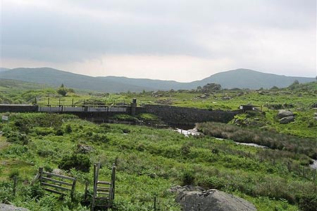
Go over the stile at the north side of the parking area (not at the end of the lane) and proceed up the wide stoned track then right after the gate at the end. The easy to follow path at first descends then sweeps round left terminating at a dam and tunnel on the Pant y Granola (Grid ref SH 724 675). Cross over the bridge then over the left stile, a low building should be down on your right. Follow the feint path ahead gradually climbing then on reaching the stream, Afon Garreg-wen (Grid ref SH 718 675), turn right and follow its course up the steep hill, cross over the fence adjacent to a Sheepfold (Grid ref SH 715 676). Continue to follow the tumbling water to a gate, don't climb over, but with the fence on your left climb up to the stile (Grid ref SH 711 678).
Cross over the stile and bear right to join the contouring footpath that heads to the end of the valley ahead. It is very feint and at times not at all. If you have a GPS then set it to grid ref SH 6905 6725. Care must also be taken not to drop down the steep flanks on your left as there is a vertical drop to the unseen Dulyn Reservoir below. If in doubt head upwards. On reaching the previous grid reference take the very short climb left up to Garnedd Uchaf (Grid ref SH 687 669).
After a well deserved rest soaking in the spectacular views with the knowledge that it is down hill from now on, follow the southern footpath for a very short way towards Carnedd Llewelyn and look out for the feint path on your left (SH 688 665) that drops steeply down the flank heading south east. The path with its fantastic views of Cwm Eigiau descends to Llyn Eigiau (Grid ref SH 720 641). Keep to the wide path that skirts the right of the water passing the remote Hafod-y-rhiw farm with it's windmill. This was dammed as a reservoir, unfortunately the wall breached (still visible) on the 2nd November 1925 and the resulting flood caused sixteen deaths in the valley below. Keeping to this now wide track leads you back to your car.
Other walks nearby
| Walk 2592 | Llyn Geirionydd & Llyn Bychan from Llyn Crafnant | moderate | 9.5 miles |
| Walk 2608 | Crimpiau & Creigiau Gleision from Llyn Crafnant | moderate | 7.5 miles |
| Walk 2679 | Circuit of Llyn Crafnant | easy | 3.5 miles |
| Walk 3061 | Eastern Carneddau from near Rowen | mod/hard | 10.5 miles |
| Walk 2547 | Carnedd Llewelyn from near Rowen | mod/hard | 12.0 miles |
| Walk 2536 | Llyn Crafnant, Capel Curig & Llyn Colwyd from Trefriw | mod/hard | 13.0 miles |
| Walk 2285 | Llyn Geirionydd & Llyn Crafnant | easy/mod | 5.5 miles |
| Walk 3056 | Pen yr Helgi Du from Ogwen Valley | moderate | 5.5 miles |
| Walk 1232 | Carnedd Llewelyn, Llyn Eigiau & Llyn Cowlyd | hard | 16.0 miles |
| Walk 2855 | Gallt yr Ogof & Braich y Ddeugwm | moderate | 4.0 miles |
Recommended Books & eBooks
Great Mountain Days in Snowdonia
 Inspirational guidebook to 40 great mountain day walks and scrambles in Snowdonia. Inspirational routes for all abilities across the National Park with routes up Snowdon and Moel Eilio, the Glyderau, the Carneddau, Eifionydd, Siabod and the Moelwynion, Rhinogydd (the Harlech Dome), Migneint and the Arans and Cadair Idris and the Tarrens.
More information
The Cambrian Way
 Guidebook to the Cambrian Way, a challenging three-week mountain trek through Wales from Cardiff to Conwy. The 470km un-waymarked route is presented from south to north. Often sticking to long, beautiful ridgelines, it crosses wild and rugged terrain and visits many of Wales's highest mountains, including Snowdon.
More information
Messaging & Social Media
Message Walking Britain and follow the latest news.

Mountain Weather
Stay safe on the mountains with detailed weather forecasts - for iOS devices or for Android devices.