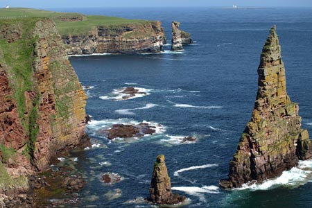
Stacks of Duncansby from Duncansby Head
Highland Walk
County/Area - Highland - Northern Highland
Author - Lou Johnson
Length - 3.0 miles / 4.9 km Ascent - 200 feet / 61 metres
Time - 1 hours 40 minutes Grade - easy
Maps 

| Ordnance Survey Explorer 461 | Sheet Map | 1:25k | BUY |
| Anquet OS Explorer 461 | Digital Map | 1:25k | BUY |
| Ordnance Survey Landranger 12 | Sheet Map | 1:50k | BUY |
| Anquet OS Landranger 12 | Digital Map | 1:50k | BUY |
Walk Route Description
Click image to see photo description.
This Highland walk visits the most north-easterly point of mainland Britain at Duncansby Head a few miles east of John O'Groats. The cliffs in this area are formed from red sandstone which has dulled through wind, weather and its proximity to the sea. During the walk you can see (in season) a wide variety of sea birds including Fulmars, Kittiwakes, Puffins, Guillemots and Great Skuas amongst others.
The start is the small car park at Duncansby Head (grid ref. ND404733) located close to the lighthouse. No maps are needed unless you want to know the names of the various features seen during the walk. All that is required is a good pair of boots as the going can be rough underfoot and suitable weatherproof clothing as the weather can change in minutes! All that is required is to follow the coast south (with the sea to your left) and follow the path as far as you wish. The return route retraces your outward steps.
After leaving the lighthouse the first major feature you encounter is a deep cleft in the cliffs - Geo of Sclaites - which can be full of wheeling seabirds at the right time of the year. The noise can be deafening from the large numbers of birds. Continuing south you will reach the viewpoint over the Stacks of Duncansby which stand as high as the cliffs they were once part of. Most people turn back here but it is worth heading further south if you have time. It is a place where you can enjoy the solitude and the noise of nature!
Other walks nearby
| Walk 3649 | Old Man of Hoy from Rackwick | easy/mod | 5.4 miles |
| Walk 3650 | Rackwick, Old Man of Hoy & Cuilags | mod/hard | 9.6 miles |
| Walk 3648 | Old Man of Hoy & Glens of Broadiface | moderate | 10.0 miles |
| Walk 3652 | The Gloup, Deerness Brough & Mull Head | easy | 4.0 miles |
| Walk 3287 | Morven, Smean & Maiden Pap | hard | 10.2 miles |
| Walk 3742 | Westness Heritage Trail | easy | 3.0 miles |
| Walk 1991 | Vat of Kirkbuster & Bay of Houseby | easy/mod | 7.6 miles |
| Walk 3651 | Noup Head from Backarass Farm, Westray | easy | 4.5 miles |
| Walk 3101 | Ben Bhraggie traverse | easy/mod | 4.7 miles |
| Walk 1791 | Tarbat Ness from Porthmahomack | moderate | 9.0 miles |
Recommended Books & eBooks
Walking in Torridon
 This guidebook contains 52 day walks in Torridon, a remote and much-loved area of the Scottish Highlands. Based around Shieldaig and Slioch, the routes are split into 3 sections: easy walks, long and high level walks and mountain ascents over 2000ft including 9 Munros, and 5 outline suggestions for major ridge walks.
More information
Great Mountain Days in Scotland
 Inspirational guidebook to 50 challenging routes for mountaineers, scramblers, hillwalkers and fell runners, many long enough to backpack over 2 days, especially in winter (12 to 25 miles). A mix of classic routes and unsung gems across Scotland from Galloway to the Outer Hebrides in widely differing wild landscapes. With customised OS mapping.
More information
Messaging & Social Media
Message Walking Britain and follow the latest news.

Mountain Weather
Stay safe on the mountains with detailed weather forecasts - for iOS devices or for Android devices.