Walk 1708 - printer friendly version
Lowesby and South Croxton Walk
Author - Anthony Maries
Length - 7.0 miles / 11.4 km
Ascent - 500 feet / 152 metres
Grade - easy/mod
Start - OS grid reference SK724075
Lat 52.660397 + Long -0.93101119
Postcode LE7 9DD (approx. location only)
Although a major city of over 1/3 million people is less than 10 miles away the area covered by this walk is remote and sparsely populated. The steady hum of traffic from the nearby city is absent, and you are unlikely to meet any other walkers. Most of the walk is on footpaths, with a couple of short sections on very quiet country lanes.
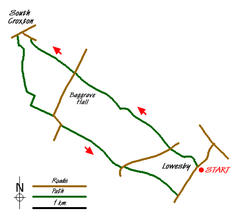
Start at the church in Lowesby (SK 724075), where the path crosses the churchyard. The church is low and modest, but very attractively built in the local yellow sandstone. It also boasts some outstanding stained glass windows. Walk through the iron gate at the far side of the church yard and follow the path across the grounds of Lowesby Hall. At the other side of the grounds, cross a minor unclassified road and continue on the path on the other side. The path now follows the Queniborough brook. On the other side of the brook there is a fox covert, one of large numbers in the county. Many of these were deliberately created and distinguish much of East Leicestershire from the agricultural prairie which much of lowland England has become.
Continue in a general northwesterly direction, crossing another path after about 600 yards, then another minor road above Baggrave Hall. Like Lowesby, the hall buildings were extremely carefully sited by the builders to give the owners superb views while concealing the building from close quarter views by the general public. Both buildings are both architecturally distinguished and historic country houses. Baggrave Hall is the only building in Baggrave, a thriving village in the Middle Ages but now, like many others the area, now little more than a name on a map.
Continue to follow the path along the north side of the brook, after 1000 yards arriving at a lily pond on the outskirts of South Croxton (locally pronounced 'Crowston' as in 'Crow'). Walk round the south and west sides of the brook to come out onto an unsurfaced lane by a horse paddock (Kings' Lane). Go left here and continue down to the end of the lane where it comes out onto a public road by the Golden Fleece. At the Golden Fleece, turn left down the road, continuing for 120 yards until you reach a footpath on the left, between private houses. Cross a small field attached to a private house, then cross the Queniborough brook. Cross four more fields, now walking in a southerly direction, then walk through New Covert. Cross one more field to come out onto a farm road by Waterloo Lodge Farm. Turn left here and follow the signposted public bridleway across parkland with distant views of Baggrave Hall down the hill.
At a bend in the road continue straight on down the bridleway. Inkerman Lodge, at the western edge of yet another small spinney, boasts the remains of a once-splendid Victorian railway carriage. Its origins are immediately apparent but it is surely now beyond proud restoration. At the far side of the spinney cross the minor road and follow the footpath leading east across fields and down to a narrow combe. At the other side of the combe cross two more fields, now walking in a south easterly direction to come out onto the very minor gated road at the top of Skeg Hill between Lowesby and Cold Newton. The start of the walk at Lowesby is about 1000 yards down Skeg Hill and on the other side of the Queniborough Brook.
Pubs: The Golden Fleece, South Croxton which welcomes walkers. Has a new beer garden and roaring fires. No pub in Lowesby.

Mountain Weather
Stay safe on the mountains with detailed weather forecasts - for iOS devices or for Android devices.

