Chiltern Hills circular from Wendover
Chilterns Walk
Region - Chilterns
County/Area - Buckinghamshire - North Buckinghamshire
Author - Peter Smyly
Length - 10.0 miles / 16.3 km Ascent - 1000 feet / 303 metres
Time - 6 hours 0 minutes Grade - moderate
Maps 

| Ordnance Survey Explorer 181 | Sheet Map | 1:25k | BUY |
| Anquet OS Explorer 181 | Digital Map | 1:25k | BUY |
| Ordnance Survey Landranger 165 | Sheet Map | 1:50k | BUY |
| Anquet OS Landranger 165 | Digital Map | 1:50k | BUY |
Walk Route Description
Click image to visit gallery of 8 images.
Waymarked trails on parts of the Ridgeway, the Icknield Way and the Aylesbury Ring form part of this circular walk that includes five hills, Bacombe, Coombe, Whiteleaf, Pulpit and Beacon Hills. Three of the hills, Coombe, Whiteleaf and Beacon provide the best panoramic views of the walk and therefore represent good places for stops. Gradients are generally gentle with one steep pull up to Pulpit Hill and another optional one up Beacon Hill. The other hill tops are reached by way of more gentle slopes. Boots are recommended as some of the paths have significantly muddy sections. You may see red kites soaring over the Beacon Hill area and beyond. The Chilterns are one of a select number of places in the UK where red kites have been re-introduced. Editor's Note some walkers have found this walk description hard to follow near Whiteleaf Hill. It is essential that you use the relevant OS map.
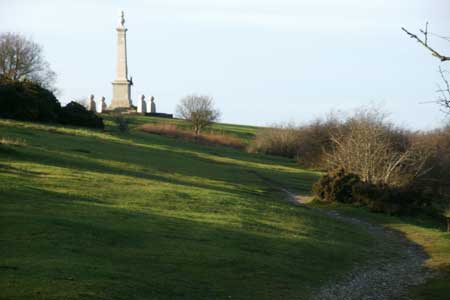
Start by following the pavement to the right of the main road out of Wendover over the railway bridge due west. Cross the road, taking care with a blind corner, to start the trail signposted for the Ridgeway and Bacombe Hill. The path initially heads up through woodland but soon emerges into the open as it gradually, but steadily, gains height and the view opens out to the right, revealing the Vale of Aylesbury and the town of Wendover is seen in retrospect. The path continues along a narrow path between trees to reach a crossroads of paths. The monument at the top of Coombe Hill can be glimpsed beyond this point where, on the other side of the crossroads, the path emerges into the open again and it is then an easy stroll over grass to the top of Coombe Hill where the best view so far is revealed. The distinctive profile of Beacon Hill, with its grassy ridge topped by a few trees, dominates the view to the west while the church at Ellesborough (which is passed later on in the walk) can be seen to the north.
Continue to follow the signposts for the Ridgeway, now going due south as the path skirts below the crest of the ridge of Coombe Hill. The path turns left into woods and then, almost immediately, goes right through a kissing gate leading through woodland to a road where you need to turn right and then left to continue the route past Lodge Hill Game Farm. For the next stretch of the route through the woods you don't need a map or compass as, every time you reach a crossroads of paths, there are signposts which ensure you stay on course for the Ridgeway. At the next T Junction of paths, bear right and the path now starts losing height quite rapidly as it heads down to a farm on the left with a road ahead. Follow the road to the west by walking along the grassy bank to the right and follow the road as it bends round to the left. A walk through the trees bordering the road brings you to a narrow path on the right and this is the way to go next. Beacon Hill can be seen beyond a field to the right as you pass a saucer-shaped, tree-filled depression on your left. The path leads towards a road and a National Trust sign for Pulpit Wood. Now follow the sign for the Icknield Way to the right, running more or less parallel to the road. At this point, Pulpit Hill is the nearest hill to the right, but this will feature later in order to include Whiteleaf Hill first. The path continues on the left-hand side of the road 50 metres before reaching a car park.
This part of the Icknield Way leads up through Sergeants Wood where it joins part of a horse riding trail. Bear right at the top of a hill in the woods and follow the path right as it undulates through woodland and, at the next T junction, the path gives way at a T junction to a much more solid path coming in from Brush Hill to the left and a walk of fifty yards or so to the right leads to a wooden gate and a Neolithic Burial Mound next to Whiteleaf Hill. A walk down the grassy slopes to the left will bring you to a point where you are directly overlooking Whiteleaf Cross just beyond a row of wooden seats overlooking Princes Risborough and beyond. Next, follow the signposts to the east-north-east, turning right along a path that goes down through woodland to the hamlet of Lower Cadsden. A path off to the right on the other side of the road about a hundred yards further down leads to another path heading towards the wooded Pulpit Hill. Even in December (2011), there were ripe rosehips around here. Next a path to the right rejoins the car park passed earlier in the walk and Pulpit Hill is a 500 metre ascent from this point, the way up being quite steep until, unexpectedly, a sign left for Pulpit Hill Fort indicates a continuation path on the level.
Woodland at the top means there are no views, unlike the other four hills on this walk. A path off to the north leads down through trees and into the open revealing Beacon Hill ahead and a signpost for the Ridgeway across a grassy field. However this time, leave the Ridgeway and instead follow a diagonal path across a field leading through more woodland before the final approach to Beacon Hill. A direct approach up the grassy slopes is not an option from this point, due to barbed wire fencing; rather the path drops rather steeply - and unexpectedly - down through the woodland of Ellesborough Warren. Emerging into the open again through a wooden gate, two rather indistinct paths appear on the right, one taking a "route one approach" up the steep grassy slopes, while another one part way up offers a less steep option by taking a diagonal traverse, Beacon Hill is arguably the best of the five hills due to its more all-round panoramic views as well as the fact that it requires a bit of effort to climb up it. The hill itself is shaped a bit like a broad whaleback and Coombe Hill now dominates the view to the east with its distinctive monument that can be seen for miles around, a reversal of one of the views seen earlier in the walk.
Now descend Beacon Hill to the north and follow the path down to Ellesborough, distinctive because of its church and, follow the path that passes the church to the left of it after crossing the busy Ellesborough Road. Emerging on to open fields, to locate the Aylesbury Ring, you need to cross a wooden stile to the right before the end of the cluster of houses. Follow the public footpath signs to Butler Cross where, despite a sign indicating a right turn, in fact the Aylesbury ring route requires you to go left along the road before crossing the road and continuing to follow the Aylesbury Ring route via a farm and then across fields. The route returns to Wendover via Wellwick Farm, with a couple of the paths across fields being particularly liable to cause your boots to gather plenty of mud. A crab apple tree, a few minutes before the conclusion of the walk, even a few days before Christmas, had plenty of ripe apples (December 2011).
Other walks nearby
| Walk 1138 | The Ridgeway at Chequers | easy/mod | 7.3 miles |
| Walk 2478 | Great Kimble Circular | moderate | 11.2 miles |
| Walk 3360 | Cholesbury Camp and Hawridge | easy | 4.4 miles |
| Walk 3098 | Tring & Wendover Woods | easy/mod | 7.5 miles |
| Walk 3669 | Grand Union Canal - Aylesbury to Wendover | moderate | 11.7 miles |
| Walk 3520 | Princes Risborough circular | easy/mod | 9.5 miles |
| Walk 2071 | Ivinghoe Beacon and Bridgewater Monument from Tring | easy/mod | 8.0 miles |
| Walk 2496 | Cow Roast and Aldbury from Tring Station | easy | 5.5 miles |
| Walk 1617 | Saunderton circular via Bledlow Ridge | moderate | 11.3 miles |
| Walk 1604 | Long Marston circular | easy/mod | 6.5 miles |
Recommended Books & eBooks
No suggestions for this area.Messaging & Social Media
Message Walking Britain and follow the latest news.

Mountain Weather
Stay safe on the mountains with detailed weather forecasts - for iOS devices or for Android devices.