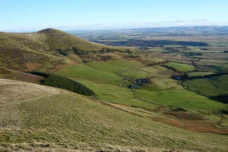
Scald Law and Pentland Hills Ridge from near Penicuik
Midlothian Walk
County/Area - Midlothian
Author - Lou Johnson
Length - 7.4 miles / 12 km Ascent - 2500 feet / 758 metres
Time - 6 hours 10 minutes Grade - mod/hard
Maps 

| Ordnance Survey Explorer 344 | Sheet Map | 1:25k | BUY |
| Anquet OS Explorer 344 | Digital Map | 1:25k | BUY |
Walk Route Description
Click image to see photo description.
The Pentland Hills lie close to Edinburgh and offer some wonderful walking. This route explores the main ridge stretching from West Kip over Scald Law to Turnhouse Hill in the east including six tops. As might be expected the route includes plenty of ascent and to fully appreciate the walk need to be completed in fine weather as the views are magnificent. It is worth noting at this point that the hills are criss-crossed by many paths so careful navigation is required.
The start is the lay-by (grid ref. NT210608) on the A702 about 5 miles southwest from the Lothianburn Junction on the A720 Edinburgh ring road. After parking walk south west along the A702 and turn right through a gate signed 'Kirk Road' and continue over open fields. Cross the Grain Burn and continue ahead to reach a path junction ignoring the signed footpath heading right. Stay on the Kirk Road, climbing steeply in places, to reach the col between Scald Law and Carnethy Hill (grid ref. NT195615).
Turn left through a gate and start the steep path to the summit of Scald Law, enjoying improving views as you gain height. At 579 metres Scald Law is the highest point on the Pentland Hills with a 360-degree panorama including the Firth of Forth and Fife. After enjoying the view continue west to reach the summit of East Kip and after a further descent and ascent the top of West Kip.
Retrace your steps along the ridge over East Kip and Scald Law to reach Kirk Road, where you first joined the ridge path. More ascent on a steep eroded path leads to the summit of Carnethy Hill (573 metres) where a different perspective of the view now includes the Forth bridges and the Southern Highlands. A steep descent now follows to a col where a steep path leads up to a cairn on the summit of Turnhouse Hill (506 metres). A further 400 metres east lies the final top (465 metres).
With most of the ascent now completed return along the ridge over the highest point of Turnhouse Hill and descend to the col before Carnethy Hill (grid ref. NT207622). Go through a gate and turn left onto a path. After a few metres bear right where the path splits. This narrow path skirts the base of Carnethy Hill with a steep drop on your left. The path turns south-west across open moorland. Rising to cross a stile, the waymarked route descends steadily eventually dropping down to join the Kirk Road. Bear right and return to the start.
Other walks nearby
| Walk 3292 | Carnethy Hill, Black Hill & Caerketton Hill | mod/hard | 12.5 miles |
| Walk 3291 | West Kip, East Kip & Scald Law | moderate | 9.7 miles |
| Walk 2241 | Gladhouse Reservoir | easy | 4.0 miles |
| Walk 1700 | Edinburgh - Royal Mile, Arthur's Seat & Princes Street | easy | 5.5 miles |
| Walk 1803 | Edinburgh - Salisbury Crags and the Royal Mile | easy | 4.0 miles |
| Walk 2061 | Edinburgh - Calton Hill and the city centre | easy | 3.0 miles |
| Walk 3294 | Trahenna Hill from Broughton | moderate | 7.1 miles |
| Walk 1979 | Culross Heritage | easy | 1.5 miles |
| Walk 3751 | Tinto (northern approach) | moderate | 4.5 miles |
| Walk 1944 | Yarrow Valley Five Hills Circular | mod/hard | 11.4 miles |
Recommended Books & eBooks
No suggestions for this area.Messaging & Social Media
Message Walking Britain and follow the latest news.

Mountain Weather
Stay safe on the mountains with detailed weather forecasts - for iOS devices or for Android devices.