Budleigh Salterton, East Devon
Jurassic Coast Walk
Region - Jurassic Coast
County/Area - Devon
Author - Devon Tourism
Length - 7.0 miles / 11.4 km Ascent - 400 feet / 121 metres
Time - 3 hours 50 minutes Grade - easy/mod
Maps 

| Ordnance Survey Explorer 115 | Sheet Map | 1:25k | BUY |
| Anquet OS Explorer 115 | Digital Map | 1:25k | BUY |
| Ordnance Survey Landranger 192 | Sheet Map | 1:50k | BUY |
| Anquet OS Landranger 192 | Digital Map | 1:50k | BUY |
Walk Route Description
Click image to see photo description.
This East Devon walk is based on the charming seaside town of Budleigh Salterton and forms a circuit, partly inland and partly using the South West Coast Path. If you would prefer, it is possible to continue the inland route into Exmouth rather than returning to Budleigh Salterton. This inland part of the walk uses a former railway, so it is also suitable for use by cyclists, wheelchair users or as a pushchair walk.
Fact File - Budleigh Salterton is accessible by bus from Exeter, Exmouth and Sidmouth. Service number 57 operates three times an hour from Exeter, four times an hour from Exmouth and once an hour from Sidmouth, Mondays - Saturdays; on Sundays twice an hour from Exeter and Exmouth, four times a day from Sidmouth. Journey time 35 minutes from Exeter, 15 minutes from Exmouth, 25 minutes from Sidmouth.
Refreshments: Budleigh Salterton: (all facilities); Littleham: (pub); Sandy Bay: (café April - October).
The Walk: Start the walk at the eastern end of the town, at the estuary of the River Otter.
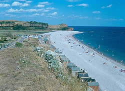
Budleigh Salterton is a charming seaside town with very much a traditional, "olde-world" character. This unspoilt character is partly a result of the pebbly beach, which prevented it from ever becoming a resort for large scale tourism. The pebbles are part of a band of infertile land known as the Bunter Pebble Beds, laid down over 200 million years ago in river beds of the time.
A bar of pebbles has built up across the mouth of the River Otter, forcing its course to the east. Behind is an attractive landscape of salt marshes, now managed as a nature reserve. Historically, the estuary was used by shipping as far inland as Otterton, 3 ½km/2 miles upriver, as indicated by the name Anchoring Hill just above that village. The mouth of the Otter is immediately recognisable by the line of pine trees on its eastern side.
Walk from the estuary alongside the car park towards the town.
Note the remains of the old lime kiln by the entrance to the car park. Lime was landed by ship and burnt in kilns such as this to improve the fertility of the soil. This one dates from the early 1800's.
Continue along the promenade to the end of Fore Street, then keep along the road, bearing away from the sea.
Note the plaque on the white house on the right (the Octagon), relating to the artist Millais. The famous painting "The Boyhood of Raleigh" is said to have been based on the wall just behind you. Raleigh himself was born at Hayes Barton, 3 ½km/2 miles inland.
Carry on along the road as far as the traffic lights, then turn right into Station Road. Near the far end of the green fork left along Moor Lane. Follow around to the right at the top, then turn immediately left by the telephone box into Bedlands Lane. On reaching the main road turn left then almost immediately right, into Bear Lane. A short way along the lane turn left through the wooden gate at the walking and cycling path.
This path leads down to the line of the Exmouth - Budleigh Salterton railway. An information board by the gate gives some background information on the railway, which closed in 1967.
Shortly after the path descends to the line of the track it crosses a bridge high above a public road. Popularly known as the "million brick bridge" it is an imposing structure seen from the road beneath, although it is uncertain whether anybody has actually counted the bricks. The number on the bridge indicates it is 171 miles and 51 chains from the old London and South Western Railway terminus at Waterloo.
The line then enters an area of woodland and plantations. The unproductive nature of the geology of the pebble beds means that heathland and woodland are the main land uses in this area. Continuing, the geology changes, and so does the landscape. The pebble beds give way to softer, more fertile soils which result in a landscape of green fields and farmland.
For the circuit back to Budleigh Salterton, leave the track and fork left just before the bridge upon reaching the edge of Exmouth (signposted to Capel Lane). (Those who wish to continue to Exmouth can follow under the bridge into the housing area. Then follow the blue or brown cycle route signs indicating Exmouth, Town Centre or cycle route. These lead to the bottom of Marpool Hill. For the town centre turn left at the roundabout at the bottom of the hill and left again at Exeter Road.)
Leaving the track, at the top of the slope turn left and continue straight ahead at the bollards into the narrow lane. Bear left at the main road and descend to the village of Littleham. The road passes the 15th-16th century church. Littleham was one of the historical parishes on which the town of Exmouth developed. It is now a suburb with buses to the town centre. Follow the road through Littleham, past the pub and up the hill into the Devon Cliffs Holiday Park at Sandy Bay. Pass the World of Country Life Museum (refreshments April - October).
From the phone box carefully follow the yellow arrows through the holiday park; follow the road half-right for a short distance then take the first left, Nutwell Glade and on ahead into Maple Park. At the end fork left and head downhill. At the bottom go straight ahead on the grass next to the hedge; this soon leads to the Coast Path. From here, turn left and the route follows the Coast Path back to Budleigh Salterton. Budleigh is soon visible ahead beyond the distinctive red cliffs. The path passes through several fields alongside some new cliff falls (take care here), and crossing four stiles. It then rises abruptly through gorse to the top of West Down Beacon.
The climb to West Down Beacon marks the change in geology, back to the pebble beds from the softer, lower, more easily eroded land behind. It also provides extensive views over the coast towards the Exe Estuary and Tor Bay beyond. The path now descends gradually into Budleigh Salterton. Just after passing through a grassy area be sure to keep right, on the Coast Path, to arrive at the sea front. Views over the town to the estuary beyond, with its characteristic pines, mark the end of the walk.
This walk is reproduced by kind permission of Devon Tourism.
Other walks nearby
| Walk 1636 | Danger Point & Ladram Bay from Otterton | easy/mod | 6.0 miles |
| Walk 2279 | Salcombe Regis & Weston Mouth | easy/mod | 5.1 miles |
| Walk 1795 | Beer & Branscombe Circular | easy/mod | 5.5 miles |
| Walk 3311 | Trenchford & Tottiford Reservoirs (Moretonhampstead) | easy | 3.0 miles |
| Walk 1550 | Charmouth & Lyme Regis Circular | easy/mod | 6.0 miles |
| Walk 2771 | Lyme Regis & Uplyme Circular | easy/mod | 5.5 miles |
| Walk 1323 | Broadsands Beach and Brixham | easy | 4.0 miles |
| Walk 1551 | Seatown and Charmouth via Golden Cap | easy/mod | 5.0 miles |
| Walk 1260 | Haytor Rocks & Hound Tor from Saddle Tor | moderate | 7.5 miles |
| Walk 3757 | Buckland in the Moor Circular | easy/mod | 6.3 miles |
Recommended Books & eBooks
The South West Coast Path
 Guidebook to walking the entire South West Coast Path National Trail. The route runs for 630 miles from Minehead to Poole along the north Devon, Cornish, south Devon and Dorset coastline. Divided into 45 stages, this long-distance coastal trek could be completed within 4 weeks, or walked in sections. Guide includes maps and essential information.
More information
South West Coast Path Map Booklet - St Ives to Plymouth
 Map of part of the southern section of the 630 mile (1014km) South West Coast Path National Trail. Covers the trail from St Ives to Plymouth along the west Cornwall and Devon coastline. This convenient and compact booklet of Ordnance Survey 1:25,000 maps shows the route, providing all of the mapping you need to walk the trail in either direction.
More information
Messaging & Social Media
Message Walking Britain and follow the latest news.

Mountain Weather
Stay safe on the mountains with detailed weather forecasts - for iOS devices or for Android devices.