Walk 2070 - printer friendly version
Tetney Lock and the Humber Estuary Walk
Author - Hugh Marrows
Length - 4.5 miles / 7.3 km
Ascent - 10 feet / 3 metres
Grade - easy
Start - OS grid reference TA342022
Lat 53.499383 + Long 0.021704758
Postcode DN36 5UW (approx. location only)
This walk can be quite bracing as it goes along to the seaward end of the Louth Navigation for great views across the marshes of the Humber estuary to Spurn Point. The Louth Navigation was built between 1765 and 1770 at a cost of £ 28,000. Unusually it was much wider than other Lincolnshire canals because it ran from Louth ran across the marshland to Tetney Lock and the tidal Tetney Haven thus creating direct access to the Humber, inland ports and the sea. Its width therefore meant that sea-going vessels could sail directly into Louth without transferring their cargoes onto small barges. So successful was this idea that Louth became, for a time, a busier port than Grimsby.
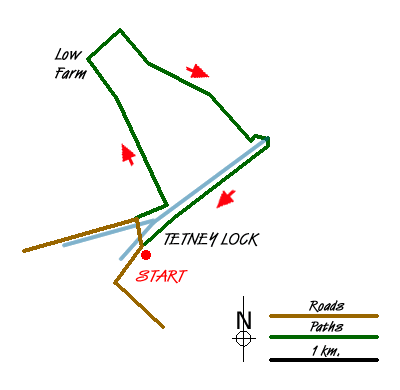
We begin from Tetney Lock where the canals final lock divided the freshwater canal from the saltwater Haven. The marshland here is so low-lying that no further lock was needed for a further seven miles, but then another six were needed over the final three miles to Louth Riverhead. In 1852 the Great Northern Railway opened their line from Grimsby to Peterborough (and London) and although this ran through Louth, the navigation stayed in business until 1920. This was the year of the disastrous Louth Flood on 29th May, which caused such damage to the canal's infrastructure at the Riverhead that the company was simply unable to afford repairs. Canal trade consequently ceased almost overnight although formal closure was not effected until June 1924. At Tetney Lock the lane opposite the Crown and Anchor is still called "The Wharf" to this day! (There is an information board about the canal outside the inn.)
Overlooking the nearby Tetney Drain are some early C19th Coastguard Cottages, which, now a mile or so from the sea, vividly illustrate how the coastal marshes have grown over the last two centuries. Close by stands an appealing Primitive Methodist Chapel of 1864. The Crown and Anchor inn itself is mid C19th too.
From the top of the Humber bank the views open up dramatically whilst also offering the opportunity to spot some of the local wildlife that frequents the estuary marshes. Since 1975 the Tetney Haven area has been an RSPB reserve extending to 1,500 hectares of marsh and dunes. There is an information board near the sluice where we cross the Haven to return to Tetney Lock.
The Humber itself also provides interest with the shipping that comes and goes from the inland ports of Grimsby, Immingham, Hull and Goole. The river's size stems from the fact that it drains a substantial part of central and northern England. It has tributaries originating on the Staffordshire moors and the Yorkshire Dales and as a result it contains one-fifth of England's fresh water.
Beyond the marsh two forts can be clearly seen guarding the main river channels; these are the Haile Sand Fort (the nearest) and Bull Sand Fort. They were built during WWI from reinforced concrete encased in steel armour plating to protect the estuary against the threat of submarines. Spurn Point can be seen too some 5 ½ miles away.
A wide variety of birds may well especially alongside the Tetney Haven as we return to Tetney Lock. Remember your binoculars too for bird and ship watching!
Notes - when the weather is good anywhere along the sea bank makes a good stopping point for picnics. There is roadside parking by the canal near the inn - or ask the landlord to use his carpark.
Route Guide
From the front of the inn cross the bridge over the navigation and continue along the road to another bridge over the Tetney Drain. Cross this too and turn right into a lane running parallel with the water channel. You may either descend onto the drain's lower flood bank or walk along the lane itself.
Just beyond a pumping station, where the lane bends sharp left (you can see this from the drain embankment) turn along it to pass a farm after which it becomes a track. Keep forward to the former site of Low Farm, climb a concrete step-stile by the gate ahead and walk to a track junction a few yards away. Turn right, then leave the track almost at once along the grass footpath ahead of you. This leads to a footbridge from which a (very) brief climb up the sea bank suddenly reveals the panorama of the Humber estuary, Humberstone Fitties, Tetney Haven, the forts and Spurn Point.
Now turn right and in 1 1/2 miles you will reach the Tetney Haven again. Go left to see the RSPB reserve information board and to cross the Haven at the nearby sluice bridge. On the far side walk ahead a few yards to a stile by a gate and beyond that a WWII pillbox.
Now turn right to a second stile by another gate and follow the Haven back inland choosing either an upper or lower embankment route. In about a mile from a final stile a short lane that leads back to the inn.
Messaging & Social Media
Message Walking Britain and follow the latest news.

Mountain Weather
Stay safe on the mountains with detailed weather forecasts - for iOS devices or for Android devices.