Rosemullion Head & Mawnan
Cornwall AONB Walk
Region - Cornwall AONB
County/Area - Cornwall
Author - Lou Johnson
Length - 4.0 miles / 6.5 km Ascent - 500 feet / 152 metres
Time - 2 hours 30 minutes Grade - easy
Maps 

| Ordnance Survey Explorer 103 | Sheet Map | 1:25k | BUY |
| Anquet OS Explorer 103 | Digital Map | 1:25k | BUY |
Walk Route Description
Click image to see photo description.
This Cornish walk includes a delightful section of the South West Coast Path and also explores the countryside inland. The start is the village of Mawnan, which lies to the south of Falmouth, where a small car park is located close to the church (grid ref. SW787272).
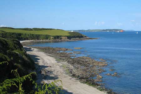
After parking take the path towards the coast. You soon reach the South West Coast Path one of the premier long distance trails in Britain. Turn right along this path (with the sea to your left) and follow the clear path as it skirts the cliffs above Parson's Beach. Where there is a choice of path it is probably better to keep to the one nearest the sea to obtain the best views. Descend past Toll Point to Porthallack and continue to Porth Saxon (grid ref. SW779271). Here turn right onto a concessionary footpath heading north up a valley. The path passes through pretty woodland and climbs easily to reach a track after just under a mile (grid ref. SW779282). Turn right along this track or access road to reach a lane after 200 metres.
Turn right along the lane and then turn left at the first junction (grid ref. SW783281). Walk past the hotel on your right and take the next footpath on your right. This leads down to the coast. Reaching the South West Coast Path, turn right and follow around Rosemullion Point and back to Mawnan using the short connecting path back towards the church and car park.
Other walks nearby
| Walk 2007 | Helford Passage & Frenchman's Creek | easy/mod | 7.0 miles |
| Walk 2009 | Gillan & Nare Point from Porthallow | easy | 4.7 miles |
| Walk 1778 | Maenporth and Helford Passage Circular | easy/mod | 8.0 miles |
| Walk 2001 | Coverack & Lowland Point | easy/mod | 4.2 miles |
| Walk 2003 | Cowlands, Coombe & Roundwood Quay from Trelissick | easy/mod | 9.0 miles |
| Walk 1878 | Poldhu Cove to Lizard Point | moderate | 9.5 miles |
| Walk 2010 | Housel Bay & Bass Point from the Lizard | easy | 3.5 miles |
| Walk 2392 | The Lizard Circular | easy/mod | 5.9 miles |
| Walk 1032 | Kynance Cove, Cadgwith & The Lizard | moderate | 8.0 miles |
| Walk 1027 | Nare Head & Portloe | moderate | 7.0 miles |
Recommended Books & eBooks
South West Coast Path Map Booklet - St Ives to Plymouth
 Map of part of the southern section of the 630 mile (1014km) South West Coast Path National Trail. Covers the trail from St Ives to Plymouth along the west Cornwall and Devon coastline. This convenient and compact booklet of Ordnance Survey 1:25,000 maps shows the route, providing all of the mapping you need to walk the trail in either direction.
More information
South West Coast Path Map Booklet - Minehead to St Ives
 Map of the northern section of the 630 mile (1014km) South West Coast Path National Trail. Covers the trail from Minehead to St Ives along the north Devon and Cornish coastline. This convenient and compact booklet of Ordnance Survey 1:25,000 maps shows the route, providing all of the mapping you need to walk the trail in either direction.
More information
Messaging & Social Media
Message Walking Britain and follow the latest news.

Mountain Weather
Stay safe on the mountains with detailed weather forecasts - for iOS devices or for Android devices.