Circuit of Cadair Idris from Minffordd
Snowdonia/Eryri Walk
Nat Park - Snowdonia - Cadair Idris
County/Area - Gwynedd
Author - Stephen Starkey
Length - 11.0 miles / 17.9 km Ascent - 4000 feet / 1212 metres
Time - 9 hours 30 minutes Grade - mod/hard
Maps 

| Ordnance Survey Explorer OL23 | Sheet Map | 1:25k | BUY |
| Anquet OS Explorer OL23 | Digital Map | 1:25k | BUY |
| Ordnance Survey Landranger 124 | Sheet Map | 1:50k | BUY |
| Anquet OS Landranger 124 | Digital Map | 1:50k | BUY |
Walk Route Description
Click image to visit gallery of 6 images.
This circuit of Cadair Idris includes a bit of everything. On the ascent via the justifiably popular Minffordd Path, a circuit of Llyn Cau is thrown in. There then follows a walk along the Northern ridge from Cyfrwy to Gau Graig. The return includes a section of pathless heather hopping that calls on basic map and compass skills. If ever there was a walk for a clear day, this is it. Unfortunately, not too many of us are able to choose the weather for our walking days.
From the rear corner of the car park you will see a well made path signed to Cadair Idris. This soon splits to give two options - one passing to the North of the small lake and one to the South. An alternative start is to walk SW along the B4405 for about 275m and then turn right on the signed footpath through the metal gates - the original entrance to the Minffordd Estate. All these paths merge near the camp site.
After passing the camp site and arriving at the edge of the woodland, pass through a wooden gate to enter the Cadair Idris Nature Reserve and start the steep climb up through the woodland. A significant proportion of the climb has been pitched with stone, making for better underfoot conditions but doing nothing to reduce the energy required to make the climb. The path basically follows the lower section of the Nant Cadair, passing close to a sequence of spectacular waterfalls before exiting the woodland via another gate.
Shortly after leaving the woodland, the path arrives at Nant Cadair with a choice of routes. The path that crosses the stream is signed to Mynnydd Moel and forms our return route. The outward route stays on the path on the West of the stream signed to Cwm Cau. The path continues to climb but at a much less severe gradient, passing to the North of Craig Lwyd. Just as Llyn Cau comes in to view, the path splits once more with the main Minffordd Path bearing left (South) to continue the ascent. We leave that for the time being and take the right hand (West) path to Llyn Cau.
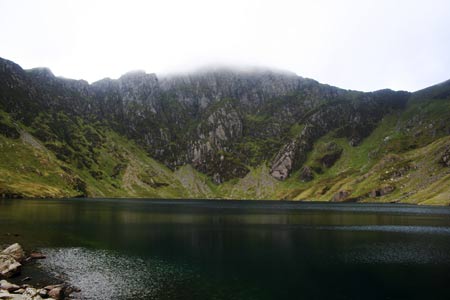
Irrespective of the weather, there can be few places more picturesque than Llyn Cau, surrounded as it is on three sides by magnificent Welsh mountains. A circuit of the lake, although increasing the overall distance of the walk, provides the legs with a welcome break from the incessant uphill work and also gives the eyes and mind a chance to feed on the full majesty of the setting.
Initially head East away from Llyn Cau to rejoin the Minffordd Path as it climbs once more heading for the ridge to the South of the lake. After the hard work involved in getting on to the ridge, the profile of the rock slabs mean the view is restricted on the North side and so a little disappointing initially. There are places though where the views down gullies to Llyn Cau are breathtaking. Shortly after the path veers to the NW, the summit of Cwm Amarch is reached and the summit of Penygadair (Cadair's highest peak) reveals itself. The descent from Cwm Amarch to the col at Craig Cau is welcome at this point of the walk and offers good views of the Cadair Idris range to the North and East.
Before following the path all the way round to the summit of Penygadair, I would strongly recommend a slight detour. As the path veers NE from just W of N at grid reference SH708127, head in a NW direction to intercept the Pony Path - the main path to Penygadair from the North. Follow the path around the rim above Llyn y Gadair to the rocks just beyond the summit of Cyfrwy which are home to some spectacular but very exposed rock climbs and grade 3 scrambles.
Retrace your steps back from Cyfrwy and onto the Pony Path which you follow to the summit of Penygadair. Just N of the true summit, marked by a trig point, is a stone built shelter-cum-bothy. Irrespective of the day or time, don't pin your hopes on having the summit of Penygadair to yourselves. The views from the summit are amongst the best I've come across on a UK mountain.
From the summit shelter, head NE on the path that follows the top of the Northern ridge of the Cadair plateau, with extensive views across Dolgellau, the Rhinogs and Trawsfynydd to the Moelwyns beyond and, on a really clear day, to Snowdon. The path continues along the top of the ridge to the summit of Mynydd Moel.
From the summit of Mynydd Moel the path descends in a South East direction, still tracking close to the Northern edge of the Cadair ridge. Once past the col at grid ref SH738137, the path becomes quite boggy in places as it runs along the right hand side of a fence until reaching another fence at grid ref. SH742140. Turn right (SE) and follow the second fence for about 60m then cross the fence by means of a small step stile to access the summit of Gau Graig.
Retrace your steps back to the col then descend gently across the moor in a basically Southerly direction to pass between the edge of the Craig Cwmrhwyddfor rock face and the boulders to the West. After passing through the gap, bear round to the South West for an easier line of descent as far as the dry stone wall. It should be noted that there is no path through the heather on this section. Bear right (W) and follow the wall. There are the starts of paths on both sides of the wall in places. The route follows the wall, fording Nant Caenewydd and about 350m beyond the stream, intersects a clear path descending from Penygadair. Turn left (SSE) and follow the rocky path as it descends quite steeply, passing North of Moelfryn, to arrive at the path junction next to Nant Cadair that was passed on the outbound route. From here it is just a matter of retracing the outward route to return to the Minffordd Car Park.
Other walks nearby
| Walk 2475 | The Dyfi Hills Ridge | mod/hard | 9.8 miles |
| Walk 1172 | Cadair Idris by the Pony Path | mod/hard | 11.0 miles |
| Walk 2668 | Cadair Idris, Craig Cau and Cyfrwy by the Pony Path | mod/hard | 5.3 miles |
| Walk 2570 | Cadair Idris from Llanfihangel-y-pennant | mod/hard | 10.0 miles |
| Walk 2707 | Tyrrau Mawr and Craig-y-llyn from Llanfihangel-y-pennant | moderate | 9.5 miles |
| Walk 1309 | Tarren y Gesail | moderate | 8.0 miles |
| Walk 1643 | Llanfihangel-y-pennant & Castell y Bere | easy/mod | 6.8 miles |
| Walk 3582 | Castell y Bere & Llanfihangel-y-pennant from Abergynolwyn | easy/mod | 5.7 miles |
| Walk 2334 | The Torrent Walk near Dolgellau | easy | 1.6 miles |
| Walk 1851 | Cregennen Lakes & Pared y Cefn-hir | easy/mod | 2.5 miles |
Recommended Books & eBooks
Snowdonia: 30 Low-level and easy walks - South
 Guidebook describing 30 walks in Snowdonia, Wales. Routes are mostly low level and on clear paths and showcase the region's beautiful scenery and rich history and culture. Part of a 2-volume set, this southern volume includes Trawsfynydd, Bala, Dolgellau, Machynlleth, the Harlech Coast and the valleys of the Mawddach and Dyfi.
More information
Great Mountain Days in Snowdonia
 Inspirational guidebook to 40 great mountain day walks and scrambles in Snowdonia. Inspirational routes for all abilities across the National Park with routes up Snowdon and Moel Eilio, the Glyderau, the Carneddau, Eifionydd, Siabod and the Moelwynion, Rhinogydd (the Harlech Dome), Migneint and the Arans and Cadair Idris and the Tarrens.
More information
Messaging & Social Media
Message Walking Britain and follow the latest news.

Mountain Weather
Stay safe on the mountains with detailed weather forecasts - for iOS devices or for Android devices.