Llyn Dinas and Cwm Bychan from Beddgelert
Snowdonia/Eryri Walk
Nat Park - Snowdonia - Moelwyns Moel Siabod Cnicht
County/Area - Gwynedd
Author - Lou Johnson
Length - 6.0 miles / 9.8 km Ascent - 1400 feet / 424 metres
Time - 4 hours 20 minutes Grade - easy/mod
Maps 

| Ordnance Survey Explorer OL17 | Sheet Map | 1:25k | BUY |
| Anquet OS Explorer OL17 | Digital Map | 1:25k | BUY |
| Ordnance Survey Landranger 115 | Sheet Map | 1:50k | BUY |
| Anquet OS Landranger 115 | Digital Map | 1:50k | BUY |
Walk Route Description
Click image to visit gallery of 6 images.
The village of Beddgelert occupies a stunning location at the junction of the Glaslyn and Colwyn rivers on the A498 and A4085. The village offers a wide range of shops and cafés etc and provides a good base for exploring this part of Snowdonia (Eryri). This half day walk is one the best of its type in the National Park and includes a mixture of mountain and valley walking. The majority of the route is over good paths however when river levels are high then the return route may be subject to flooding and you may need to take an alternative route.
The start is the large pay and display car park (Grid ref. SH587481) just off the A498 on the western side of the village. Exit the car park onto the A498 and turn left into the village centre. Just before reaching the bridge where the road crosses the river, turn right down the lane with the river on your immediate left. Go past the public conveniences and cross the footbridge over the Glaslyn river. After crossing the footbridge bear left and follow the path alongside the river to reach a lane (Grid ref. SH592480). Go straight over and continue alongside the river to reach another lane (Grid ref. SH595483). Turn right onto this lane and follow it past the campsite to reach the entrance to Sygun Copper Mine.
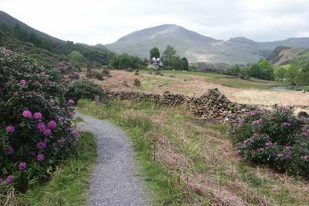
The route at this point is rather confusing but you need to follow the mine access road to the bridge over the Glaslyn river where you turn right with the river a short distance away on your left. This path then continues without any further navigational problems to reach the shores of Llyn Dinas with its superb mountain backdrop. Almost immediately fork right on a well maintained path. This climbs at a fairly easy gradient into the hills with an ever improving retrospective view over the lake.
Reaching a path junction (Grid ref SH607482) at Bwlch-y-Sygun, turn left and start the descent to Nantmor. You will pass the remains of a cableway once used to move copper ore down to the West Highland Railway at Nantmor where it was taken to Porthmadoc for shipment. This descent takes through a natural rockery garden complete with a stream and plenty of wild flowers in season.
The reopening of the Welsh Highland Railway has caused some changes to rights of way at Nantmor. It was possible to walk the old railway track through a tunnel back to Beddgelert but this route has now been closed so you need to follow the more challenging alternative riverside path. Having reached the railway track, cross over through the new gates and follow the path through woodland to Pont Aberglaslyn (Grid ref. SH594462). There are a number of paths through this wood and the best advice is keep left. This will bring you to the bridge without too much problem.
Do not exit onto the road but take the path that descends right. This follows the river with some sections of boardwalk. Generally speaking the path is fairly straightforward but children need careful supervision on the first section. If there has been heavy rain for a prolonged period, then the path may be impassable if the river level is high and you will need to follow the alternative route detailed below. The first section (approximately 500 metres) of this path offers a spectacular view of the river and the Aberglaslyn gorge in which it flows.
The path eventually becomes wider and leaves the river bank. Reaching a footbridge, cross the Glaslyn river. Turn right on the other side and continue along the riverside into the village. If you wish, you can make the short diversion to visit "Gelert's Grave", which is to your left in the grassy open space. According to legend, the stone monument in the fields, marks the resting place of "Gelert" the faithful hound of the medieval Welsh Prince Llywelyn the Great. From the monument continue on the wide path to return to the village.
Note : The alternative route is to use the road from Pont Aberglaslyn back towards Beddgelert leaving the road (Grid ref. SH591473) to follow the riverside path for the final section into the village.
Other walks nearby
| Walk 1427 | Craflwyn circular from near Beddgelert | easy/mod | 2.5 miles |
| Walk 3058 | Llyn yr Adar & Llyn Edno from near Bethania | moderate | 9.0 miles |
| Walk 1192 | Yr Aran | mod/hard | 6.5 miles |
| Walk 1103 | Snowdon & Cwm Llan horseshoe | very hard | 13.0 miles |
| Walk 2290 | Snowdon via the Watkin Path & South Ridge from Bethania | mod/hard | 8.0 miles |
| Walk 1136 | Yr Aran (Route 2) | moderate | 5.5 miles |
| Walk 1515 | Tops and Tarns of the Moelwyns | mod/hard | 11.0 miles |
| Walk 2590 | Nantlle Ridge Walk from Rhyd Ddu (Route A) | moderate | 6.0 miles |
| Walk 2797 | Yr Aran and Snowdon from Rhyd-Ddu | mod/hard | 8.5 miles |
| Walk 3509 | Nantlle Ridge from Rhyd Ddu (Route B) | mod/hard | 8.3 miles |
Recommended Books & eBooks
Mountain Walking in Snowdonia
 Guidebook to 40 of Snowdonia's best day walks, with routes up Snowdon and Tryfan, including the Snowdon Horseshoe, Cadair Idris, Y Garn and The Rhinogs. The routes range from Grade 1 scrambles like Crib Goch or Bristly Ridge, to riverside and forest walks. Includes details of a 2-day traverse of all 15 of Snowdonia's 3000ft peaks.
More information
The Wales Coast Path
 A single guidebook to walking the whole Wales Coast Path - 1400km (870 miles) the length of Wales from Chester to Chepstow, including Anglesey, described in 57 stages. The route passes through the Snowdonia and Pembrokeshire National Parks and many AONBs and can be linked with the Offa's Dyke Path for a complete circuit of Wales.
More information
Messaging & Social Media
Message Walking Britain and follow the latest news.

Mountain Weather
Stay safe on the mountains with detailed weather forecasts - for iOS devices or for Android devices.