The Needles & Tennyson's Monument from Nodewell Farm
Isle of Wight AONB Walk
Region - Isle of Wight AONB
County/Area - Isle of Wight
Author - Lou Johnson
Length - 4.0 miles / 6.5 km Ascent - 350 feet / 106 metres
Time - 2 hours 20 minutes Grade - easy
Maps 

| Ordnance Survey Explorer OL29 | Sheet Map | 1:25k | BUY |
| Anquet OS Explorer OL29 | Digital Map | 1:25k | BUY |
| Ordnance Survey Landranger 196 | Sheet Map | 1:50k | BUY |
| Anquet OS Landranger 196 | Digital Map | 1:50k | BUY |
Walk Route Description
Click image to visit gallery of 9 images.
This walk explores the wonderful chalk cliffs and downs at the western end of the Isle of Wight. The start is the small car park located in a quarry (grid ref. SZ324856) at the end of the lane that runs south past Nodewell farm just off the minor road running from Freshwater Bay to Alum Bay.
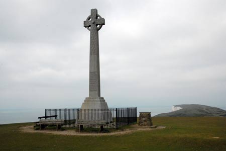
After parking take the path that is on the eastern side of the carpark (the left hand side as you enter the parking area). This leads steeply in places up through woodland into open downland with the impressive Tennyson Monument ahead of you. From here the view extends along the southern coast of the Isle of Wight.
From the monument turn west walking with the sea to the left. Remember there are high unprotected cliffs so care is needed with children. There is a main ridge path and a lesser used path that follows the cliffs more closely. Take the latter eventually reaching a stile in a wire fence (grid ref. SZ318851). Cross the stile and continue now with a fence between you and the cliffs. Continue in a westerly direction aiming for the radio mast ahead.
Cross the fence here, pass the radio station and drop down on a stony path to a concrete road. Bear left and then turn right on a concrete path to the observation point for the Needles. This area was used for rocket testing in the 1960s and 70s and there are some information boards detailing this piece of modern history. The observation post offers the best view of the Needles from the land.
Return to the concrete road and bear left. This will lead you round to the Needles Old Battery now managed by the National Trust. In season there are refreshments available here. To continue walk up to the old coastguard cottages and take the path that goes behind them. This leads you back onto the downs. Instead of dropping down to the clifftop path used on the outward route stay on the crest of the ridge. This path offers some excellent views across Alum Bay to the mainland.
Reaching a junction of paths at a fence (grid ref. SZ318853) continue ahead and take the chalk track veering left away from the main ridge path which continues towards the Tennyson Monument. This track leads easily back to the car park.
Other walks nearby
| Walk 2311 | The Needles & Tennyson's Monument from Freshwater Bay | easy/mod | 6.0 miles |
| Walk 1546 | Yarmouth, Freshwater and Norton from Yarmouth | easy | 5.0 miles |
| Walk 2414 | Compton Down and Five Barrows from Compton Chine | easy/mod | 5.0 miles |
| Walk 3541 | Keyhaven & Hurst Castle | easy | 3.3 miles |
| Walk 2435 | Compton Down circular | moderate | 12.5 miles |
| Walk 1751 | St Catherine's Hill & Coastal Path | moderate | 6.7 miles |
| Walk 3142 | Bowcombe Down | easy | 4.8 miles |
| Walk 1601 | Bowcombe Down & Upper Watchingwell | easy/mod | 8.0 miles |
| Walk 3542 | RAF Beaulieu near East Boldre | easy | 5.1 miles |
| Walk 3685 | RAF Beaulieu Walk from Hawkhill Inclosure | easy | 3.6 miles |
Recommended Books & eBooks
No suggestions for this area.Messaging & Social Media
Message Walking Britain and follow the latest news.

Mountain Weather
Stay safe on the mountains with detailed weather forecasts - for iOS devices or for Android devices.