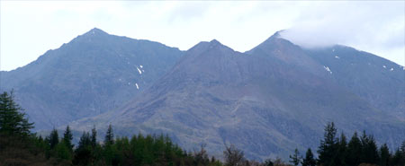
Glyder Fach from Capel Curig
Snowdonia/Eryri Walk
Nat Park - Snowdonia - Glyders Tryfan
County/Area - Conwy
Author - Stephen Starkey
Length - 11.5 miles / 18.7 km Ascent - 3200 feet / 970 metres
Time - 9 hours 0 minutes Grade - mod/hard
Maps 

| Ordnance Survey Explorer OL17 | Sheet Map | 1:25k | BUY |
| Anquet OS Explorer OL17 | Digital Map | 1:25k | BUY |
| Ordnance Survey Landranger 115 | Sheet Map | 1:50k | BUY |
| Anquet OS Landranger 115 | Digital Map | 1:50k | BUY |
Walk Route Description
Click image to visit gallery of 11 images.
A full day outing amongst some of the most spectacular peaks of Snowdonia (Eryri) but approaching from a relatively quiet direction. With the masses drawn to the main 'honeypot' peaks, the chances are that, apart from the section around Tryfan and Glyder Fach, you will have the hills to yourself for large parts of the day. The paths are fairly clear throughout, though the route is boggy in places. When considering how far to walk along the main ridge of the Glyderrau, bear in mind the walk out from the foot of Tryfan back to Capel Curig, though basically flat, is 6.4km (4 miles) and can sap the energy at the end of a day in the mountains. If staying at the Youth Hostel (grid ref. SH726579), leave the car in the hostel car park. Alternatively there is a free National Park car park (grid ref. SH720582) behind Joe Brown's outdoor shop in the village.
This Snowdonia (Eryri) walk is one of those that enjoys stunning views before you even set off - in this case the view being of the Snowdon Horseshoe from the front of the hostel. From Capel Curig Youth Hostel, head NW along the main A5 for just over 1km to the centre of Capel Curig then take the lane straight ahead at the junction, signed to a car park (which makes an alternative start point) and also signed as a public footpath. The path climbs gently, passing Joe Brown's Outdoor Shop and the National Park Car Park before going through a gate and into the open country. Follow this lane for about 600m until, just after passing below a farm, another path merges from the left. Turn sharp left to double back on this path towards the farm. Just as you get to the farm gate, where the main path continues through the farm yard, a smaller grassy path turns off to the right. Take this path to the right and start to climb the path, passing between rocky outcrops.
About 500m after joining the path, the view to the North West suddenly opens up, revealing views of the high Carneddau. The path then turns to the South West for 150m or so before climbing West between rock outcrops to the minor top of Cefn y Capel which offers great views of Moel Siabod across Llynnau Mymbyr to the South; The Snowdon Horseshoe to the South West and The Carneddau to the North. Continue Westwards along the clear path as it undulates over a few minor tops amidst ground that can be boggy. After crossing the wall the path steepens appreciably as it climbs towards the summit of Gallt yr Ogof - the easternmost summit on main the Glyder ridge - from where you get impressive views of the Glyderrau, with Tryfan and Y Foel Goch being most prominent.
Follow the path South West as it descends to boggy ground before climbing to the summit of Y Foel Goch - a fine vantage point for views of Tryfan, Bristly Ridge and the main Glyder ridge. The rocky monoliths of Tryfan's Adam and Eve are visible with the naked eye, with the assistance of binoculars or a zoom lens, you may even see somebody making the leap of faith between the two. The path is initially fairly clear as it descends from the summit of Y Foel Goch but disappears for a while across the boggy plateau. Just after crossing the col, a path, identified as the Miner's Track on the OS map, joins from the left (South). A few metres further on, a small cairn on the right (at SH 6671-5825) marks the start of a path towards Bwlch Tryfan. Take note of where the cairn is as this marks the start of the return descent.
The path now continues ahead in a Westerly direction to start the climb towards Glyder Fach and the underfoot conditions change from easy walking across predominantly grass path to a steeper gradient picking your route across sizeable rocks en route to the summit of Glyder Fach. As the path starts to climb, there are impressive views to the right along the Nant Ffrancon valley. The area around the summit contains some spectacular rock formations that mean it is generally possible to find shelter from the wind. The most spectacular rock formation however - The Cantilever Stone - offers no shelter from the elements.
From the summit of Glyder Fach it is only a short walk west to the spectacular Castell y Gwynt rock formation. From Castell y Gwynt, retrace your route back as far as the small cairn noted earlier near the Miner's Track. Turn left at the cairn and start the descent on the rocky path, which is quite steep initially, heading towards Bwlch Tryfan. This stage of the route offers terrific views of Bristly Ridge - a famous Snowdonia (Eryri) scramble to Glyder Fach.
As the slope levels off, the path splits at SH 6655-5835. The left hand branch heads North West towards Bwlch Tryfan but this route takes the right hand branch which heads north and descends Cwm Tryfan. The path descends across the lower slopes of Tryfan, from where you get a real impression of the massive size of the mountain. Look carefully at the rocks and you will probably be able to pick out some climbers, looking very tiny and insignificant against the massive rock face.
Continue to follow the rocky path down Cwm Tryfan to the stile over the dry stone wall. After crossing the wall, follow any of the paths for the final descent around Tryfan Bach to meet the bridleway next to Gwern Gof Uchaf camp site. Turn right and follow the bridleway along the valley. For the first 2km or so there are impressive views of Tryfan behind you. Eventually the path loops around the crags of Creigiau'r Gelli to come back to the fork in the path where you turned off to start the climb of Cefn y Capel earlier in the day. Keep left here and retrace the outward route back to the start of the walk.
Other walks nearby
| Walk 3402 | Moel Siabod circular from Pont Cyfyng | moderate | 6.5 miles |
| Walk 3005 | Clogwen | easy | 2.0 miles |
| Walk 1151 | Moel Siabod | hard | 5.5 miles |
| Walk 2919 | Moel Siabod & Capel Curig | moderate | 6.0 miles |
| Walk 3056 | Pen yr Helgi Du from Ogwen Valley | moderate | 5.5 miles |
| Walk 1232 | Carnedd Llewelyn, Llyn Eigiau & Llyn Cowlyd | hard | 16.0 miles |
| Walk 2855 | Gallt yr Ogof & Braich y Ddeugwm | moderate | 4.0 miles |
| Walk 1332 | Gwydir ForestLakes from Tyn Llwyn | easy/mod | 6.5 miles |
| Walk 2285 | Llyn Geirionydd & Llyn Crafnant | easy/mod | 5.5 miles |
| Walk 2592 | Llyn Geirionydd & Llyn Bychan from Llyn Crafnant | moderate | 9.5 miles |
Recommended Books & eBooks
Snowdonia: 30 Low-level and easy walks - North
 Guidebook describing 30 walks in Snowdonia, Wales. Routes are mostly low level and on clear paths and showcase the region's beautiful scenery and rich history and culture. Part of a 2-volume set, this northern volume includes the Snowdon area, the Ogwen and Conwy Valleys, Betws-y-Coed, Beddgelert, Ffestiniog and the coast.
More information
Snowdonia: 30 Low-level and easy walks - South
 Guidebook describing 30 walks in Snowdonia, Wales. Routes are mostly low level and on clear paths and showcase the region's beautiful scenery and rich history and culture. Part of a 2-volume set, this southern volume includes Trawsfynydd, Bala, Dolgellau, Machynlleth, the Harlech Coast and the valleys of the Mawddach and Dyfi.
More information
Messaging & Social Media
Message Walking Britain and follow the latest news.

Mountain Weather
Stay safe on the mountains with detailed weather forecasts - for iOS devices or for Android devices.