Walk 2331 - printer friendly version
Whin Fell & Ouster Rake from Dunsop Bridge Walk
Author - Lou Johnson
Length - 8.3 miles / 13.5 km
Ascent - 1400 feet / 424 metres
Grade - moderate
Start - OS grid reference SD661501
Lat 53.9458860 + Long -2.5179707
Postcode BB7 3BB (approx. location only)
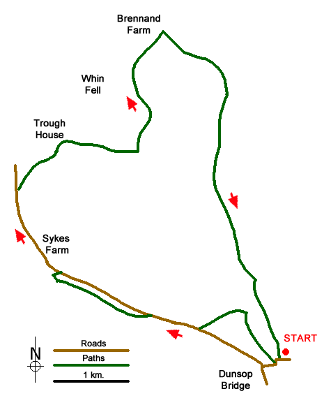
The Forest of Bowland offers many excellent walks in often wild scenery. The village of Dunsop Bridge is the start of this route from the car park located at the eastern end of the village (grid ref. SD661501). After parking exit the car park and turn right. Cross the bridge over the River Dunsop and continue along the road until you reach a stone cross on your right-hand side. Turn right here following the signed bridleway for 800 metres to reach Closes Barn. A few metres after turn left onto a field path leading west.
Continue over a second field to reach a road at a metal gate (grid ref. SD650504). Turn right along the lane and continue for 600 metres to reach the access drive for Hareden Farm on your left (grid ref. SD643506). Walk left over the bridge and take the signed permissive footpath on the right. This leads parallel to Langden Brook, which is on your right. After a kilometre, you reach another bridge. Cross the bridge to a kissing gate and turn left down a track to reach the road (grid ref. SD632511).
Turn left along the road and continue for about a kilometre passing Sykes Farm and a waterworks. Reaching Trough Barn on your right, take the signed bridleway on the right. The track climbs steadily passing Trough House before reaching a stile at a saddle (grid ref. SD643530) with the summit of Whin Fell on your left. If time and energy permits you can make a detour to the summit following the fence. You will be rewarded with some wonderful views over the Forest of Bowland and surrounding areas.
To continue cross the stile and continue steeply down Ouster Rake, which can be a tricky descent in wet and icy conditions. Reaching the bottom of the rake, go through gate and continue to isolated Brennand Farm (grid ref. SD645541). Nearing the farm, aim for the gate at the top of field before the farm. Then follow a farm track across fields to a ladder stile, with the farm on your right onto the farm access road.
Turn right (downhill) passing Lower Brennand on your left. Shortly after (grid ref. SD653535), the track divides. Keep right here and continue down the valley crossing to the west bank of the river before Foot Holme (grid ref. SD652531). After approximately 2 kilometres you reach a footbridge (grid ref. SD656509). Cross this bridge and follow the east ban of the river, ignoring the footpath to Beatrix on your left. This soon becomes a track which leads back to the car park used at the start.
Messaging & Social Media
Message Walking Britain and follow the latest news.

Mountain Weather
Stay safe on the mountains with detailed weather forecasts - for iOS devices or for Android devices.