Circuit of Nether Beck and Over Beck from Wasdale
Lake District Walk
Nat Park - Lake District - Lake District Western Fells
Wainwrights - Haycock, Scoat Fell, Red Pike (Wasdale), Steeple, Yewbarrow
County/Area - Cumbria
Author - Stephen Starkey
Length - 11.3 miles / 18.3 km Ascent - 4040 feet / 1224 metres
Time - 9 hours 40 minutes Grade - hard
Maps 

| Ordnance Survey Explorer OL4 | Sheet Map | 1:25k | BUY |
| Anquet OS Explorer OL4 | Digital Map | 1:25k | BUY |
| Ordnance Survey Explorer OL6 | Sheet Map | 1:25k | BUY |
| Anquet OS Explorer OL6 | Digital Map | 1:25k | BUY |
| Ordnance Survey Landranger 89 | Sheet Map | 1:50k | BUY |
| Anquet OS Landranger 89 | Digital Map | 1:50k | BUY |
Walk Route Description
Click image to visit gallery of 9 images.
This Lake District walk starts from the car park beside the road up Wasdle at Overbeck Bridge. After parking, leave the car park and head Southwest along the Wasdale Road to the Netherbeck Bridge. From the bridge, continue along the road for a further 470m to a finger sign for a public bridleway cutting back North. At the time I did this walk, October 2006, this sign was starting to rot and looked in a bad way so I am not sure how much longer it will survive. It may be prudent to 'pace' the distance from the bridge because the bridleway, initially, is not too obvious.
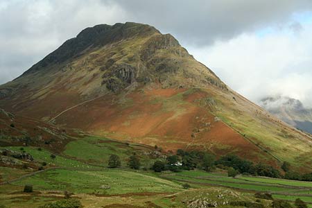
Follow the path as it climbs away from the road, battling through the dense bracken for a while. As the path closes on Nether Beck once more, there are wonderful views across Bowderdale to Yewbarrow and also across Wast Water to the Scafells. It is worth studying Yewbarrow for a moment or two at this point and picking out your descent route for the end of the day. The three days prior to us doing this walk had seen "God extensively watering Cumbria", making the ground extremely wet underfoot. However, it also made for some spectacular waterfalls immediately West of Middle Fell. Be warned, they are not the easiest to photograph.
The path, now much more obvious, but still wet and rocky, swings round to head NW for a while, still tracking Nether Beck, to arrive at a waterfall in a small gorge at Rough Crag. The noise was deafening, making me suspect the fall was really something, but I couldn't find a route I was prepared to use to try and get close. It was hard to believe we were walking in Wasdale at this point. It was a dry day in early October and we had not met another soul yet.
The climb now starts to steepen a little, as the route crosses countless gills, becks or streams. Most times these crossings will cause little concern but when in spate after 3 days of heavy rain, care is required, particularly at Ladcrag Beck and Waver Beck. Mist permitting, you now get your first view of Haycock.
The OS Explorer map would have you believe that at grid ref NY152098 a fence or wall on the opposite side of Nether Beck veers away East from the stream. Reality is that the fence no longer exists though you will see the occasional rusted metal fence post. However, at this point, with a very prominent rock formation ahead (see photo), the path forks, both branches being much vaguer than the path to date. At this point take the left hand branch of the path, heading just W of N, to climb quite steeply on the slopes to the East of Gowder Crag.
After a steep pull up, the gradient eases for a while before increasing again on the last rise to a col between Haycock and Scoat Fell. At this point turn left for the short walk, albeit quite steep, to the summit of Haycock - a mountain that appears to be a Mist Magnet. We have climbed Haycock from Ennerdale, from Caw Fell, as an extended Mosedale Horseshoe, from Seatallan and now from Nether Beck. Even on clear days on other parts of our walks, come the summit of Haycock, the mist has been down and the visibility close to nil.
From the summit, retrace your steps back to the col and then continue ahead on the climb to Little Scoat Fell. At this point, it is worthwhile making the short 'out and back' diversion to Steeple. Although not technically difficult, this does involve crossing a short, narrow, exposed ridge where a good head for heights is needed. I am not sure I would want to cross this ridge in strong winds. It was on the summit of Steeple that we met two other walkers - the first people we had seen since leaving the car park.
Return across the ridge to Scoat Fell. Here, pick up the path that heads off in a SE direction on the wide ridge above Scoat Tarn and on through rocks and boulders to the summit of Red Pike. From Red Pike the path ahead is not always obvious amidst the rocky terrain, but as a rule of thumb, it keeps quite close to the ridge above Mosedale, which is on your left. There follows quite a long, reasonably steep descent from Red Pike, heading S or SE towards Dore Head, with the massive bulk of Yewbarrow getting ever closer.
Once at Dore Head, you will see a path on the left, heading NE down to a sheepfold in Mosedale. This descent of Dorehead Scree is evil. Viciously steep down loose scree all the way and is not recommended under any circumstances. If the legs are tiring at this point, serious consideration should be given to either of the paths heading SW down Over Beck. The main route continues ahead to start the short but very steep ascent of Stirrup Crag to the summit of Yewbarrow. This ascent of the Northern shoulder of Yewbarrow requires some basic skills and confidence to scramble but is not difficult and is soon over.
We came across three more people on Stirrup Crag and another 2 on Yewbarrow itself. In the 7 ½ hours we were walking in Wasdale, we met a total of 7 other people. Who says you cannot find solitude in the Lake District honeypots? Continue ahead across the long, broad summit ridge of Yewbarrow as it undulates across more minor tops until arriving at a small cairn at the top of Great Door. Here you go half right to start out on the very steep descent seen from the start of the walk. It looks very disconcerting from the top and is not a place for those nervous in descent. This section should not be rushed. A nice steady pace will soon have you at the point where the Eastern Over Beck path joins.
From the point where the paths merge, continue around the Southern flanks of Yewbarrow to a stile. Cross the wall by means of the stile and then turn right for the steep grassy descent to Over Beck and the waiting car. Note that your descent is on the left of the wall but the OS map shows the path being on the right. If you put your faith in OS, you will find no way to easily cross the wall later on.
Notes - The path along Nether Beck is very wet and very rocky, making for hard and slow going. My partner chose to wear Goretex lined fabric boots for this walk and wished she had not. Despite lots of TLC and water repellent beforehand, her boots soaked up water to such an extent that they weighed 3 ½ times more at the end of the walk than they did at the start.
The ascent of Steeple can easily be omitted. The ascent of Yewbarrow involves an easy scramble up Stirrup Crag and a very steep descent on the scree of Great Door which is unpleasant at the end of a long day. Yewbarrow can be omitted by descending SW from Dore Head with a choice of paths on both sides of Over Beck.
Other walks nearby
| Walk 1126 | Mosedale Horseshoe | hard | 11.5 miles |
| Walk 1246 | Black Sail Pass & Beck Head | moderate | 5.5 miles |
| Walk 2034 | Scafell from Wasdale Head | hard | 6.5 miles |
| Walk 2800 | The Scafells via Piers Gill from Wasdale Head | mod/hard | 7.5 miles |
| Walk 2900 | Pillar (by the High Level Path) from Wasdale | mod/hard | 8.0 miles |
| Walk 2718 | The Scafells from Wasdale Head | mod/hard | 9.0 miles |
| Walk 1303 | Buckbarrow, Seatallan & Middle Fell from Loweswater | moderate | 7.0 miles |
| Walk 3489 | Scale Bridge & Low Wood from Greendale | easy | 5.2 miles |
| Walk 3485 | High Birkhow & Low Wood from Wast Water | easy | 4.2 miles |
| Walk 2355 | Blea Tarn & Eskdale Green | easy/mod | 6.5 miles |
Recommended Books & eBooks
Outdoor Adventures with Children - Lake District
 Guidebook to 40 outdoor adventures in the Lake District with children under 12, including walking, cycling, orienteering, paddling, boating, hostelling and more. Graded activities for varying age ranges or for families with children of different ages.
More information
The Cumbria Way
 A guidebook to the 73 mile Cumbria Way, an easy long-distance walk though the heart of the Lake District National Park, from Ulverston in the south to Carlisle in the north, with good transport links to either end. The route is largely low-level but this guide offers alternative mountain days to climb some of the famous fells en route.
More information
Messaging & Social Media
Message Walking Britain and follow the latest news.

Mountain Weather
Stay safe on the mountains with detailed weather forecasts - for iOS devices or for Android devices.