Walk 2411 - printer friendly version
Albury Circular Walk
Author - Donald Morton
Length - 7.5 miles / 12.2 km
Ascent - 500 feet / 152 metres
Grade - easy/mod
Start - OS grid reference TL436247
Lat 51.902343 + Long 0.08585575
Postcode SG11 2JQ (approx. location only)
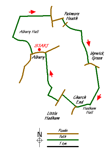
Albury is a little village about 3 ½ miles NW of Bishops Stortford and some 4 miles SE of Buntingford on the A10. The walk as described starts from Albury church where it is possible to park in the lane outside. (Grid Ref TL436247) (An alternative starting point is Patmore Heath Nature Reserve Grid Ref TL443258.) The church dates from the 13th - 15th centuries and although it seems to have been extensively restored in the Victorian period there are interesting features as well as memorial brasses remaining. The delightful neighbouring cottages are recently re-thatched - we watched part of the work in progress!
But the walk starts off in the opposite direction from the cottages, passing the village school on the right and turning up the lane to the right with a notice "Albury Hall Private Road". Follow this, ignoring a bridleway to the right and the next track to the right, to a footpath on the right just at the end of some woods. Go through the old iron kissing gate and follow the track through the edge of the woods to emerge onto grass. Cross the grass to a drive and turn right. Once through some dilapidated farm buildings, the drive has an estate red brick wall on the right. This is the boundary of Albury Hall once, apparently, the HQ of Special Operations Executive and pulled down in the 1950s.
Once past a large house turn right and, having now joined the Hertfordshire Way, continue past its hedged boundary and along this wide gravel track to the road. Turn right and walk with care (for what appears to be a minor road it is surprisingly busy but apparently it did use to be a C numbered road before these were abolished!) down into the hamlet of Gravesend. At The Catherine Wheel Pub, turn left up the lane alongside and soon arrive at the Patmore Heath Nature Reserve, an SSSI. (There is parking available here so this could be a starting point for the walk - with The Catherine Wheel at the end!) Look out for an information board on the right. Turn right here and passing to the left of the board cross the heath aiming for a light coloured bungalow.
Cross the road and go down the footpath to the right of The Hunting Lodge. The footpath starts as tarmac, becomes an enclosed cobble road and then gravel to arrive at a real "chocolate box" cottage on the left. Here dogleg right/left over a tarmac drive to continue up a broad track along a field edge - hedge left. Pass through a narrow strip of woods to continue down and up between fields with views of Albury to the right. Pass woods on the right and continue down a field edge - hedge right - and down a drive to a lane in Upwick Green. Turn left and follow the lane to a bridleway sign; turn right here up the drive to Upwick Hall. Pass the Hall on the right and continue straight on down a green lane which becomes a field edge track - hedge left. At a fork take the right hand sandy track heading towards Hadham Hall, seen ahead. Once home to the Earls of Essex, this historic Elizabethan building was for 38 years from 1953 a co-ed school with some boarders and run by Herts CC.
The walk does not actually reach the Hall but just before leaves the Hertfordshire Way and turns right down a bridleway which skirts the associated houses and continues down a sandy track aiming for the church seen ahead. When a group of four Victorian estate cottages is reached a worthwhile short diversion left will take you to the 14th Century church for Little Hadham which is actually quite a way from the village. Otherwise continue down the track to the right of the cottages to a road where you turn left to reach the village itself. Take the first footpath right, a wide gravel cum tarmac drive, and when this finishes fork right down a green lane. Go over the bridge and turn right; at the next waymark turn right again along a field edge - ditch right. At the field corner go over a bridge, turn right and go with the field edge - hedge right. Cross over a track and continue with field edge with woods right. OS Landranger 167 does not appear to be totally accurate at this point but when the woods end turn sharp right along a track at the edge of the woods. At a T junction turn left and follow this broad gravel track to a road. Turn left to reach the church in Albury.
Messaging & Social Media
Message Walking Britain and follow the latest news.

Mountain Weather
Stay safe on the mountains with detailed weather forecasts - for iOS devices or for Android devices.