White Nothe & Moigns Down from Osmington
Jurassic Coast Walk
Region - Jurassic Coast
County/Area - Dorset
Author - Lou Johnson
Length - 10.5 miles / 17.1 km Ascent - 1400 feet / 424 metres
Time - 6 hours 40 minutes Grade - moderate
Maps 

| Ordnance Survey Explorer OL15 | Sheet Map | 1:25k | BUY |
| Anquet OS Explorer OL15 | Digital Map | 1:25k | BUY |
| Ordnance Survey Landranger 194 | Sheet Map | 1:50k | BUY |
| Anquet OS Landranger 194 | Digital Map | 1:50k | BUY |
Walk Route Description
Click image to visit gallery of 6 images.
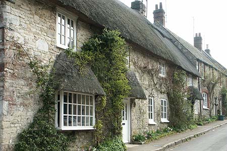
This walk uses a section of the South West Coast Path to explore the Dorset coast between Osmington Mills and White Nothe. The return route crosses the downs finishing in the village of Osmington with its many thatched cottages, both original and new.
The village of Osmington lies to the north of the A353 west of Weymouth. The village offers limited parking near the church on the road (Grid ref. SY724830) leading north from the main road to Netherton Farm. After parking, return to the main road and turn left along the A353. After 300 metres, go right on the South West Coast Path (inland option) towards the coast. Ignore the cross path in the third field and continue straight ahead to a lane (Grid ref. SY735820). Turn right down the lane.
The path continues east along the coast and leaves the lane to go to the left of the pub. Kept straight ahead along the top of the low cliffs and continue all the way through to Ringstead. Stay with the South West Coast Path which turns inland (Grid ref. SY750813), before turning right and running parallel to the shore. The path then starts the climb above Burning Cliff. The path is well waymarked and you continue climbing beyond Holworth House to reach Whitenothe Cottages perched nearly 500 feet above the sea. Stay on the Coast path for a further 500 metres past the highest point of the cliff to reach a path junction (Grid ref. 778808). The view ahead to Lulworth and beyond is superb with white cliffs stretching as far as you can see.
Go left here inland along the fence to a bridleway. Turn left on the bridleway and begin the return to Osmington. Keep straight on ignoring any side tracks for just under 2 km. At the junction (Grid ref SY763820) after Sea Barn Farm, take the righthand track and continue across the undulating downs to Holworth. Just past the farm look out for a bridleway on your left (Grid ref. SY766834). At the time when this walk was researched there was no sign and the bridleway goes through a gate on the opposite of the track just past the farm. This route goes along the base of a shallow valley to reach a junction of bridleways (Grid ref 758837). Be careful here. The route you need to follow goes half left and climbs onto Moigns Down past the remains of a trig point.
In places the way ahead is not too clear. If in doubt stay on the left hand (southern) side of the crest of down until you reach a track that descends to the A353 (Grid ref. SY742835). Turn left along this busy main road. You need to cross the road at a dangerous corner so extreme caution is required. Having survived the traffic, take the signed bridleway (Grid ref SY741834) that leads uphill across the down to a junction by Pixon barn (Grid ref SY735838). Go left here and follow the ridge as it descends to a lane into Osmington and the start of the walk.
Other walks nearby
| Walk 1889 | White Nothe from Ringstead Bay | easy/mod | 5.8 miles |
| Walk 2575 | Durdle Door & Lulworth Cove | moderate | 10.0 miles |
| Walk 1004 | Durdle Door & Lulworth Cove | easy | 2.5 miles |
| Walk 1329 | Durdle Door & White Nothe from Lulworth Cove | moderate | 7.0 miles |
| Walk 3389 | Bindon Hill and the Fossil Forest from Lulworth | easy/mod | 4.0 miles |
| Walk 2370 | The Fleet from Langton Herring | easy/mod | 7.0 miles |
| Walk 3523 | Abbotsbury & Portesham Circular | easy | 5.2 miles |
| Walk 3748 | Southover Heath from Tolpuddle | easy | 5.0 miles |
| Walk 2289 | Abbotsbury Castle and Chesil Beach | easy/mod | 6.0 miles |
| Walk 2565 | Littlebredy from Abbotsbury | moderate | 8.5 miles |
Recommended Books & eBooks
Walking the Jurassic Coast
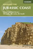 This guidebook includes 30 walks on the Jurassic Coast of Devon and Dorset. Covering the coast between Exmouth and Bournemouth, these delightful routes range from 3 to 16 miles (5 to 24km), exploring and explaining the spectacular geology of this World Heritage area with clear, easily understood descriptions, cross-sections and timelines.
More information
South West Coast Path Map Booklet - St Ives to Plymouth
 Map of part of the southern section of the 630 mile (1014km) South West Coast Path National Trail. Covers the trail from St Ives to Plymouth along the west Cornwall and Devon coastline. This convenient and compact booklet of Ordnance Survey 1:25,000 maps shows the route, providing all of the mapping you need to walk the trail in either direction.
More information
Messaging & Social Media
Message Walking Britain and follow the latest news.

Mountain Weather
Stay safe on the mountains with detailed weather forecasts - for iOS devices or for Android devices.