Littlehampton to Climping
West Sussex Walk
County/Area - West Sussex
Author - Jean Blemings
Length - 5.0 miles / 8.1 km Ascent - 100 feet / 30 metres
Time - 2 hours 40 minutes Grade - easy
Maps 

| Ordnance Survey Explorer OL11 | Sheet Map | 1:25k | BUY |
| Anquet OS Explorer OL11 | Digital Map | 1:25k | BUY |
| Ordnance Survey Landranger 199 | Sheet Map | 1:50k | BUY |
| Anquet OS Landranger 199 | Digital Map | 1:50k | BUY |
Walk Route Description
Click image to visit gallery of 5 images.
This short walk can either be started from Littlehampton Rail Station (grid ref TQ025021) or further along the route as described from West Beach car park (grid ref. TQ027012). It is especially good for children because there are various diversions along the way.
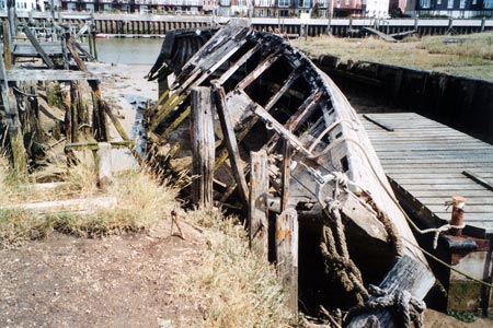
If you are starting from the rail station, exit and turn right to walk up the road running parallel to the railway line at some stage endeavouring to cross over the rather busy road as you need to take the next road off to the left. Cross over the river using the sturdy red footbridge and once you are over the river and have enjoyed the views both up and downstream turn left again heading away from Littlehampton Marina and walk down the road running parallel with the river which is flanked by nautical type shops and holiday home parks. Where the road becomes narrower and loses the flanking buildings look for a footpath off to the left bearing onwards on the same heading as the road but slightly nearer to the river. This soon brings you out onto the west side of the riverbank with some ship wrecked boats and old jetties and wharfs to add interest. Keep on walking down river as the path rejoins the side of road and becomes sandier. Eventually as the river widens and flows more strongly into the sea you will come to a car park (the alternative starting point for this walk if travelling by car) and a café and toilets.
After availing yourselves of whichever of the facilities you require, look for the duck boarded path leading off to the right passing by the front of the toilets. This path leads off up, over and through the dunes for a short way. There are a few information boards and you pass by the ruins of an old Napoleonic fort on the right before the path deposits you on the shingle beach.
Here turn right and head westwards along the beach. At low tide there is sand exposed and you can paddle although it might be unwise to swim due to the strong currents in the vicinity of the rivers outfall. There follows what feels like a fairly lengthy stretch of beach walk but the time can be passed by a bit of beach combing and admiring the views onwards along the coast towards Selsey Bill.
You are aiming for the next set of obvious breakwaters. The dunes continue on the landward side and where they start to flatten and are replaced by tamarisk shrubs after passing an old mill you may see a road off to your right. This is a private access road and the footpath is still along the beach above the high tide mark.
Eventually you reach another car park and café and a public road which ends at the car park. Turn right up the road walking between flint faced buildings. The road becomes quite leafy but take care as it can be quite busy with cars driving down to the beach although there is usually enough of a verge to making walking on the roadside pretty safe. There are ferns and trees either side of the road and you pass the entrance to a hotel complex on your left and a footpath marked off to the right. Continue on up the road and eventually on the right you will see the Black Horse pub a welcome watering hole after your tramp along the beach and road walk.
Shortly after the pub there is a footpath off to the right by a row of ornately thatched cottages topped by an unusual miniature boat made of thatch instead of the more usual birds. Take this path on a track in front of the cottages and where the track bends round the cottages strike out in a straight line across the fields on the same heading as the path started out on.
You come to a crossing byway which you pass straight over and then continue across another couple of fields on the same heading approaching what look like some low ruined farm buildings made of flint. Here bear round to the right on a curving track to reach another waymark that directs you across another field to a gate set into an area of scrub. Pass through this gate and walk through the trees on a clearly defined path. You cross over a small concrete footbridge over a narrow stream and shortly after reach a further crossroads of paths where again you should carry straight on along another tree-lined path.
Eventually you pass to the landward side of the old mill you noticed from the beach on the first half of the walk. A footpath up from the beach comes in from your right but continue onwards on the path which now skirts the landward side of the golf course parallel with the line of dunes and shoreline you started out along. Although it crosses the golf course the path is very pretty and raised up on a slight embankment and well segregated from the golf course. It is flanked by varied shrubs, bramble patches and reed beds and the occasional glimpse of golfers. Keep following the very obvious path and eventually you will emerge at the road to the West Beach car park where you previously took the path on the other side of the road to take you out onto the river bank.
Now you can either walk back down to the car park if you started there or retrace your steps back to the rail station. If you have time to spare you might also want to explore the east bank of the river with its riverside developments, cafes and exhibition centre as a contrast to the gentler and more undeveloped west side.
Other walks nearby
| Walk 1423 | Midhurst Way - Arundel to Midhurst | mod/hard | 19.0 miles |
| Walk 2835 | Arundel to Amberley | easy | 6.2 miles |
| Walk 3080 | Arundel Park and the River Arun | easy/mod | 7.2 miles |
| Walk 3305 | Amberley Mount and Wepham Down | easy/mod | 8.0 miles |
| Walk 1917 | Rackham Hill from Amberley | easy/mod | 6.5 miles |
| Walk 1615 | Amberley & East Dean Circular | mod/hard | 21.0 miles |
| Walk 1466 | Amberley and Arundel Circular | moderate | 13.0 miles |
| Walk 1628 | Bignor Hill and The Denture from Amberley | moderate | 8.7 miles |
| Walk 1629 | The River Arun & South Stoke | easy | 4.6 miles |
| Walk 1667 | Blackpatch Hill & Harrow Hill from near Storrington | easy/mod | 7.2 miles |
Recommended Books & eBooks
No suggestions for this area.Messaging & Social Media
Message Walking Britain and follow the latest news.

Mountain Weather
Stay safe on the mountains with detailed weather forecasts - for iOS devices or for Android devices.