Pike o' Stickle, Harrison Stickle & Pavey Ark
Lake District Walk
Nat Park - Lake District - Lake District Central Fells
Wainwrights - Harrison Stickle, Pavey Ark, Pike O'Stickle
County/Area - Cumbria
Author - Bill Milne
Length - 6.0 miles / 9.8 km Ascent - 2600 feet / 788 metres
Time - 5 hours 40 minutes Grade - moderate
Maps 

| Ordnance Survey Explorer OL6 | Sheet Map | 1:25k | BUY |
| Anquet OS Explorer OL6 | Digital Map | 1:25k | BUY |
| Ordnance Survey Landranger 90 | Sheet Map | 1:50k | BUY |
| Anquet OS Landranger 90 | Digital Map | 1:50k | BUY |
Walk Route Description
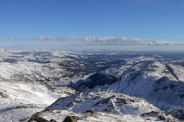
Click image to visit gallery of 3 images.
This Lake District walk in Langdale was undertaken in fresh snow, up to three feet deep in places, which made it all the more spectacular, and is a variation to the usual 'tourist route' which starts with Pavey Ark. In good conditions I would allow a comfortable 5 hours to take in the tremendous views.
Parking across from the Stickle Barn pub at New Dungeon Ghyll Hotel and walk directly up the road opposite, passing through the gate behind the pub and on to the well marked path. Follow this to a stile and with the wall now on your right, ascend towards Thorn Crag. In terms of navigation, this is the trickiest bit of the day.
Pass between Thorn and Gimmer Crags, with the conical Pike o' Stickle as the first target of the day. From here the views across to the more famous Peaks are incredible, but this walk itself is not without it's spectacular scenery.
Coming off the Pike, follow the well trodden path to cross a stream before climbing steadily to the summit of Harrison Stickle. From the cairn, the third summit of Pavey Ark can be seen atop an impressively rugged face, with the Tarn glimmering way below. If you're feeling energetic, continue NNE to Thunacar Knott, otherwise bear NNW along the ridge to Pavey Ark. In the snow this was quite a scramble through the outcrop that forms the summit.
Rather than descending via the North Rake, skirt the rocks towards the gully which conducts Bright Beck to Stickle Tarn. Attaining the Tarn, follow the path which borders it and leads to the dam wall. From here there is a well trodden path passing under Tarn Crag, which follows the Ghyll down to the welcoming warmth and fine ale of the hotel.
Other walks nearby
| Walk 1132 | Great Langdale & The Crinkle Crags | mod/hard | 7.0 miles |
| Walk 1157 | Bowfell and Esk Pike | hard | 8.8 miles |
| Walk 2037 | Bowfell & Rosset Pike via the Climber's Traverse | hard | 7.5 miles |
| Walk 2818 | Bowfell Circular from Great Langdale | mod/hard | 7.0 miles |
| Walk 1739 | Crinkle Crags and Bowfell (Oxendale Horseshoe) | hard | 7.8 miles |
| Walk 1134 | Wetherlam and The Carrs | mod/hard | 10.8 miles |
| Walk 2270 | Tilberthwaite and Holme Fell Little Langdale | easy/mod | 5.5 miles |
| Walk 1207 | Great & Little Langdales | moderate | 8.5 miles |
| Walk 2042 | The Langdale Pikes with an ascent of Jack's Rake | very hard | 6.3 miles |
| Walk 2073 | Harrison Stickle, Pike o'Stickle & Rosset Pike | moderate | 8.3 miles |
Recommended Books & eBooks
Lake District: High Level and Fell Walks
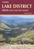 This guidebook describes 30 graded fell walks on the ridges and high peaks of the English Lake District, the UK's most popular national park. Reaching some of England's finest and highest mountain scenery, this guide leads readers to classic horseshoes and traditional ascents as well as lesser-known routes to quieter summits.
More information
Great Mountain Days in the Lake District
 An inspirational guidebook to 50 challenging walks on the high fells of the Lake District. The graded circular routes, between 4 and 14 miles in length, cover classic Lakeland summits like Fairfield, Scafell Pike, Great Gable and Blencathra, to the lesser-known High Spy, King's How and Brund Fell.
More information
Messaging & Social Media
Message Walking Britain and follow the latest news.

Mountain Weather
Stay safe on the mountains with detailed weather forecasts - for iOS devices or for Android devices.