Win Hill & Hope Cross
Peak District Walk
Nat Park - Peak District - Great Ridge Castleton
County/Area - Derbyshire
Author - Jake Robertson
Length - 7.5 miles / 12.2 km Ascent - 1600 feet / 485 metres
Time - 5 hours 20 minutes Grade - moderate
Maps 

| Ordnance Survey Explorer OL1 | Sheet Map | 1:25k | BUY |
| Anquet OS Explorer OL1 | Digital Map | 1:25k | BUY |
| Ordnance Survey Landranger 110 | Sheet Map | 1:50k | BUY |
| Anquet OS Landranger 110 | Digital Map | 1:50k | BUY |
Walk Route Description
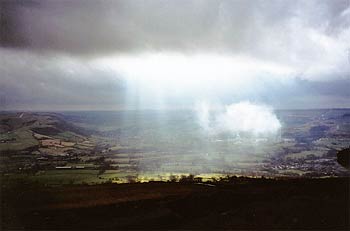
Click image to see photo description.
I have done this Peak District walk many times as I consider Win Hill to be the finest top in the National Park, especially when ascended via Parkin Clough. This is one of our favourite afternoon walk, especially winter when the summit is usually deserted!
The start is the Yorkshire Bridge with ample parking on the A6013 about a mile north of Bamford near the Ladybower Dam (Grid ref. SK201854).
Descend to and cross the Yorkshire Bridge. Go right through a gate to join a road to Ladybower Dam. After a short way you will see some steps on the left. These lead up to a dismantled railway. Go straight across to join a thin path which leads to Win Hill Plantation.
This is the hard bit with some particularly steep and muddy parts on a relatively thin path but once you reach a stile and signpost the main ascent is over. A sign points to Win Hill so go straight ahead slowly ascending to another stile. Go over the stile and make the final, short scramble to the Trig Point on the summit.
The views are stunning from its 462m. summit. The rocks on the top make a perfect place for your well deserved lunch! Scramble down off the summit and join a path heading roughly west which follows a ridge for just over a mile to a wall where the path splits. Continue by the wall, which is adjacent to the pine woods, to arrive at a fork. Go left to pass through a gate. Hope Cross is only a short distance away.
The views from this ancient marker post are good, especially down the Vale of Edale. From here walk up to the signpost prominent from Hope Cross (Grid ref. 161874). Then go right to bend down to the shores of Ladybower Reservoir. From here turn right and follow the track keeping the reservoir on your left. This leads you all the way back to Yorkshire Bridge past Ladybower Dam.
Other walks nearby
| Walk 3540 | The Derwent Edge from Cutthroat Bridge | moderate | 10.0 miles |
| Walk 1090 | Stanage Edge | moderate | 7.0 miles |
| Walk 1286 | Castleton Great Ridge & Mam Tor | moderate | 8.5 miles |
| Walk 2599 | Kinder Scout and Castleton Ridge from Hope | mod/hard | 13.5 miles |
| Walk 1706 | Win Hill from Hope | easy/mod | 6.5 miles |
| Walk 1098 | Howden Edge & Derwent Valley | mod/hard | 14.0 miles |
| Walk 1213 | Alport Castles | moderate | 8.5 miles |
| Walk 1219 | Back Tor & the Wheel Stones | moderate | 10.3 miles |
| Walk 2591 | Crook Hill & Ladybower Reservoir | easy/mod | 7.5 miles |
| Walk 2548 | Stanage Edge from Hathersage | moderate | 8.5 miles |
Recommended Books & eBooks
Dark Peak Walks
 Guidebook to 40 walks in the Dark Peak area of the Peak District National Park. 35 circular routes for most abilities, from 8km to 19km, around Edale, Marsden, Fairholmes, Baslow and Castleton, including Kinder Scout and Mam Tor, and 5 longer (25km to 45km) routes highlighting the best of the Gritstone Edges, High Moorland and Deep Valleys.
More information
Walking in Derbyshire
 Walking guidebook to 60 circular day walks in Derbyshire and the Peak District. Includes the Derwent, Wye and Trent river valleys, near Derby, Matlock, Glossop, Bakewell and Ripley. Routes range from easy to moderate and are between 4 and 14km (2 to 10 miles). Walks focus on places of interest, from Stone Age forts to castles to grand estates.
More information
Messaging & Social Media
Message Walking Britain and follow the latest news.

Mountain Weather
Stay safe on the mountains with detailed weather forecasts - for iOS devices or for Android devices.