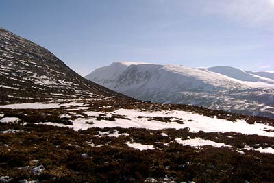
Lairig Ghru & Chalamain Gap from Glenmore
Cairngorms Walk
Nat Park - Cairngorms - Cairngorm North
County/Area - Highland
Author - Paul Gasson
Length - 11.0 miles / 17.9 km Ascent - 1600 feet / 485 metres
Time - 7 hours 10 minutes Grade - mod/hard
Maps 

| Ordnance Survey Explorer OL57 | Sheet Map | 1:25k | BUY |
| Anquet OS Explorer OL57 | Digital Map | 1:25k | BUY |
| Ordnance Survey Landranger 36 | Sheet Map | 1:50k | BUY |
| Anquet OS Landranger 36 | Digital Map | 1:50k | BUY |
Walk Route Description
Click image to visit gallery of 2 images.
This route starts at the Glenmore Visitor Centre approximately 4 miles east of Aviemore and reached off the B970 at Coylumbridge. Although not including any high peaks in the Cairngorms, the walk nevertheless includes some rough mountain walks with intimate views of this magnificent landscape.
Leave the Visitor Centre and walk east towards Loch Morlich to locate the cycleway on the north side of the road. Cross the outfall from Loch Morlich by the bridge and enter Rothiemurchus forest. Follow the forest road from about 1.6 km (1 mile) to a sign for Lairig Ghru.
Follow the footpath for 1.3 km (0.8 miles) to an obvious crossroad ( Piccadilly). Go left here to approach the Lairig Ghru on a rough hill path with some exposed sections above the Allt Druidh. Continue on this path for 4.5k (3 miles) climbing steadily from Piccadilly to reach the point where the path crosses the Allt Druidh at around the 600 metre contour.
Do not cross the river instead turning due North from here. The route climbs gently on a rough path to reach the Chalamain Gap. This ravine is completely choked by boulders and care is needed not to twist an ankle with easy scrambling for about 0.5 km before emerging onto a good hill path across the moor.
This moorland path eventually enters the ravine of the Allt Choire Chais which is crossed by a footbridge, from where an excellent path leads to the Ski Road some 2 km. from the start. The road walk can be avoided by crossing the road and continuing on a footpath on the other side of the road which crosses the Allt Mor on a footbridge and rejoins the road at Hayfield, close to the start.
Other walks nearby
| Walk 2412 | Craiggowrie & Creagan Gorm from Loch Morlich | mod/hard | 7.3 miles |
| Walk 1904 | Loch Morlich circular (near Aviemore) | easy | 4.0 miles |
| Walk 1605 | Loch an Eilein & Rothiemurchus Forest from Loch Morlich | easy/mod | 10.0 miles |
| Walk 2421 | Braeriach via the Chalamain Gap | hard | 15.0 miles |
| Walk 1881 | Ben Macdui & Cairn Lochan from the Ski Centre | hard | 10.4 miles |
| Walk 2672 | Cairngorm Mountain via Coire an t-Sneachda | mod/hard | 6.0 miles |
| Walk 1390 | Cairn Lochan via the Fiacaill Buttress from Ski Centre | very hard | 5.7 miles |
| Walk 1276 | Loch Avon Circular via Cairn Gorm Mountain | hard | 9.0 miles |
| Walk 2314 | Cairngorm & Ben Macdui from the ski centre | hard | 11.0 miles |
| Walk 1721 | Braeriach via Lairig Ghru | hard | 18.2 miles |
Recommended Books & eBooks
Skye's Cuillin Ridge Traverse
 This 2-volume set provides all the information required to complete the main ridge traverse on Skye's Black Cuillin. Strategy, gear, training, navigation and logistics are covered, and 10 classic scrambles are described. A lightweight second guidebook gives the scrambler detailed maps, topos and route description for the ridge traverse itself.
More information
Great Mountain Days in Scotland
 Inspirational guidebook to 50 challenging routes for mountaineers, scramblers, hillwalkers and fell runners, many long enough to backpack over 2 days, especially in winter (12 to 25 miles). A mix of classic routes and unsung gems across Scotland from Galloway to the Outer Hebrides in widely differing wild landscapes. With customised OS mapping.
More information
Messaging & Social Media
Message Walking Britain and follow the latest news.

Mountain Weather
Stay safe on the mountains with detailed weather forecasts - for iOS devices or for Android devices.