Merrick from Glen Trool Walk
Walk 2623 - Route Maps & Profile
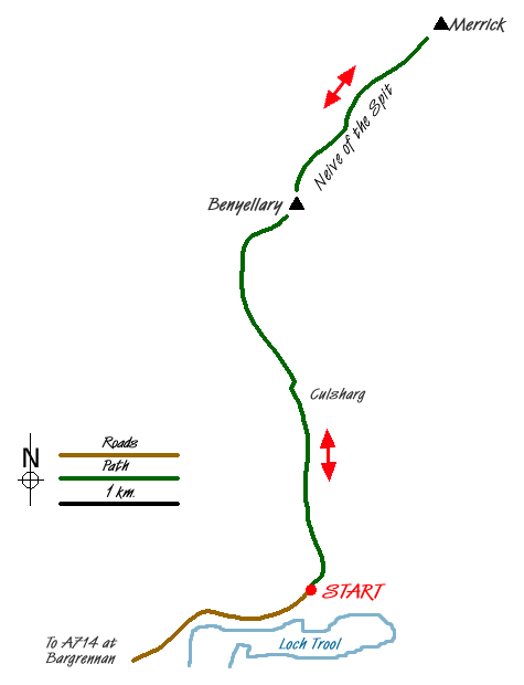
Route Map
Digital Maps - Copyright © 2011-2024. All rights reserved.
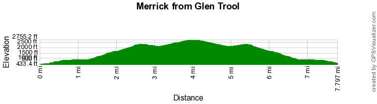
Route Profile
Sketch Map
Suggested Maps 

| Ordnance Survey Explorer 318 | Sheet Map | 1:25k | BUY |
| Anquet OS Explorer 318 | Digital Map | 1:25k | BUY |
| Ordnance Survey Landranger 77 | Sheet Map | 1:50k | BUY |
| Anquet OS Landranger 77 | Digital Map | 1:50k | BUY |
It is recommended you take a map. The preferred scale is 1:25k.
Start Point Details
Ordnance Survey Grid Ref NX415804
Latitude 55.092632 Longitude -4.485238
Postcode DG8 6SU
what3words start bedding.curtains.responses
Walk description may contain detailed information on the start point for this walk.
Further Information
Dumfries and Galloway
Dumfries and Galloway is located in south-west Scotland and shares a short border with England. The area has a lengthy coastline including along the Solway Firth. Inland there are ranges of hills including Merrick the highest hill rising to 843 metres above sea level. Long distance footpaths include the Southern Upland Way.
Walk grading - Learn how each walk is assessed and select a walk to suit your ability and experience by going to Walk Grading Details.
Messaging & Social Media
Message Walking Britain and follow the latest news.

Mountain Weather
Stay safe on the mountains with detailed weather forecasts - for iOS devices or for Android devices.