Cawthorne Roman Camp Circular
North York Moors Walk
Nat Park - North York Moors - North York Moors East
County/Area - North Yorkshire
Author - Andy Chaplin
Length - 12.2 miles / 19.8 km Ascent - 1200 feet / 364 metres
Time - 7 hours 20 minutes Grade - moderate
Maps 

| Ordnance Survey Explorer OL27 | Sheet Map | 1:25k | BUY |
| Anquet OS Explorer OL27 | Digital Map | 1:25k | BUY |
| Ordnance Survey Landranger 100 | Sheet Map | 1:50k | BUY |
| Anquet OS Landranger 100 | Digital Map | 1:50k | BUY |
Walk Route Description
Click image to visit gallery of 3 images.
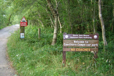
This walk starts at the (free) North Yorkshire Moors parking at the Cawthorne Roman Camps site just north of Cawthorne (grid ref. SE783895) where there is plenty of room to park amongst the trees. The walk is a circuit taking in part of the Tabular Hills Walk, the Cropton forest walks, the Seven valley and Cropton Banks. At the end there is also the circuit of the camps and the panorama where you can see a good deal of the walk you have just done.
Come out of the parking area back along the entrance track, turn right on the road and the right again on the road to Keldy Banks which forms part of the Tabular Hills walk. Turn off opposite Keldy Banks on the path signed as the THW and follow the path through the trees and past Ellerton Lodge. Follow the path to the right of the house at High Cawthorne then take the track straight ahead - rather than the road to Thornsby House.
Keep heading north on the path which becomes a track - at which point you stop following the THW and now follow part of the Moor To Sea cycle network. The track becomes Middle Head Road and just past High Farm you take the Rutmore Road track on your left. The track through Cropton forest is signed as MTSCN past High Muffles to Muffles Rigg at grid ref. SE766936. At this point carry straight on taking the path through the trees. The going is more difficult here and although it may look like you can cross just one forest track and then take the second one in order to angle down from 762935 to Spiers Bank House the track does not exist and you would remain on Spiers Bank - too far from the Seven.
Having got onto the track alongside the river Seven go past Spiers Bank House and come out on Moor Bank Lane. Go right over the Hartoft bridge then take the path over the stile on your left alongside the beck. Cross the river Seven on the stepping stones and continue up the moor side until you meet the track where you go left past High Askew and come onto Askew Rigg Lane.
Follow the road to Lower Askew, turn left over the Seven and on to Cropton Bridge. Turn right up to Cropton on the road. There is no path until the THW joins just below the old castle hill. Stay on the THW route as it turns off the road and cuts up a path towards St Gregory's church and then along High Lane back to the Cawthorne parking.
If you then follow the signed walk around the camps not only can you see the Roman earthworks but you will come to the viewpoint at the north west corner of the site where you can see most of the walk that you have just completed.
Other walks nearby
| Walk 1397 | Hole of Horcum from Levisham Station | easy/mod | 8.5 miles |
| Walk 3337 | Dundale Pond from Levisham | easy | 4.8 miles |
| Walk 3585 | Skelton Tower & Hole of Horcum from Levisham | easy/mod | 7.4 miles |
| Walk 1396 | Hole of Horcum and Saltergate Brow from Lockton | moderate | 10.3 miles |
| Walk 1867 | Hole of Horcum & Bridestones from Lockton | moderate | 9.8 miles |
| Walk 1930 | Wheeldale Moor circular | moderate | 11.3 miles |
| Walk 2029 | Lastingham & Rosedale from Hutton-le-Hole | moderate | 12.0 miles |
| Walk 3534 | Dundale Pond & Hole of Horcum from Saltergate | easy/mod | 5.2 miles |
| Walk 1921 | Spaunton Moor from Chimney Bank | easy/mod | 8.1 miles |
| Walk 1602 | Saltergate, Fylingdales & Allerston High Moor | moderate | 11.5 miles |
Recommended Books & eBooks
Trail and Fell Running in the Yorkshire Dales
 Guidebook to 40 of the best trail and fell runs in the Yorkshire Dales National Park. Ranging from 5 to 24 miles, the graded runs start from bases such as Ribblehead, Dent, Sedbergh, Malham and Grassington and take in the region's diverse delights, from castles and waterfalls to iconic mountains such as Whernside, Ingleborough and Pen Y Ghent.
More information
Messaging & Social Media
Message Walking Britain and follow the latest news.

Mountain Weather
Stay safe on the mountains with detailed weather forecasts - for iOS devices or for Android devices.