Walk 2726 - printer friendly version
Penistone Circular from Scout Dike Reservoir Walk
Author - Andy Chaplin
Length - 8.3 miles / 13.5 km
Ascent - 900 feet / 273 metres
Grade - moderate
Start - OS grid reference SE235048
Lat 53.5393250 + Long -1.6468764
Postcode S36 7EZ (approx. location only)
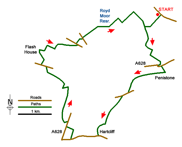
The walk starts at the Yorkshire Water car park at the side of Scout Dike Reservoir at SE235048. The route takes in two reservoirs, a section of the old Woodhead railway line, the western section of the Penistone Boundary Walk (PBW) and the Royd Moor viewing point.
From the car park take the steps down to the dam wall and walk on the track at the side of the dam. When the permissive path turns off right to follow the reservoir take the path on the left and pick up the Penistone Boundary Walk (PBW) until that also heads off north at which point you go south on the path and then track to Top o' th' Town.
The track bends eastwards before coming out on Old Anna Lane. Turn right on the road and then left on Work Bank Lane. Just after Wesley View house there is a path off on the right that goes across fields to the river Don. Half way across the field you join a track from the right - this is part of the Pen-Den Trail. When the path splits go right towards Hoyle Mill Lane then follow that to the main road. Cross the river then take the second road off on the right - Stottercliffe Road.
The road turns into a path and then meets the old Woodhead railway line. Turn right on the railway path (the Pen-Den Trail goes off left) and follow the track westwards for half a mile. Just past a walking signpost at Leapings Lane turn off the railway track onto Bank House lane then take the path off on the left in front of Far Bank House. The path comes up onto Hillside Lane where you turn right and then off left on the first track - Hartcliffe Lane.
This becomes a path which skirts around the wood at Hartcliff Hill and then comes out on Hartcliffe Road. There are good views northwards across the Don valley. When you turn right on the road you are now on the Penistone Boundary Walk. The PBW dog-legs down to the Manchester Road, crosses it then goes off across country again to Bullhouse Hall Farm. Cross the old railway turn right on Bullhouse Lane then immediately off left towards Bullhouse Mill.
The path keeps going north-west through Catshaw, goes along Catshaw Lane, across Lee Lane and off right and around Flash Hose Farm. Go right on Hollin Lane up to Small Shaw Farm and walk through the car park and then down towards the pond below Eagle Nest Farm which is on the hill above and to the left of you. This part of the PBW can be swampy.
The path climbs up then picks up a track to come out on Whitley Road. Going left and then first right on the roads brings you to the Royd Moor Viewing Point. It may well be a good view - sadly, all that I saw was mist. At the next road junction go left and then take the path off to the right. This goes down across Royd Moor to Royd Moor Reservoir. When you approach the south end of the reservoir you pick up an old path running alongside a water channel then onto a new (for 2017) path that takes you onto Folly Lane.
Turn right on Folly Lane then left around the side of Folly farm. The path here takes you to Bell Royd house. You then have to go a long way parallel with the reservoir in order to get back onto the path that leads to the reservoir wall and the car park.

Mountain Weather
Stay safe on the mountains with detailed weather forecasts - for iOS devices or for Android devices.

