Capel Pinnacle / Y Pincin from Capel Curig
Snowdonia/Eryri Walk
Nat Park - Snowdonia - Western Carneddau
County/Area - Conwy
Author - Jake Robertson
Length - 1.0 miles / 1.6 km Ascent - 250 feet / 76 metres
Time - 0 hours 50 minutes Grade - easy
Maps 

| Ordnance Survey Explorer OL17 | Sheet Map | 1:25k | BUY |
| Anquet OS Explorer OL17 | Digital Map | 1:25k | BUY |
| Ordnance Survey Landranger 115 | Sheet Map | 1:50k | BUY |
| Anquet OS Landranger 115 | Digital Map | 1:50k | BUY |
Walk Route Description
Click image to see photo description.
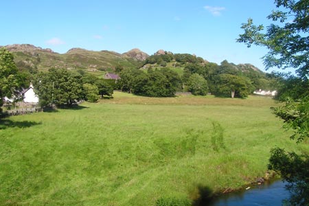
The Capel Pinnacle is a well known landmark, a little rocky knoll a few hundred feet above Capel Curig. It's barely a walk to its 860ft/264m top but it offers tantalising views of Snowdon and the higher mountains and has plenty of scrambling for entertaining hour or two.
Walk out of the car park onto the main road by the junction. Cross the junction to a cross by the chapel and go over a stile into a field, following a path which passes to the left of the Pinnacle. Once over another wall it's a simple matter of picking the best route up to the summit. The easiest way is by climbing round the north side where a series of paths and easy scrambles bring you to the rocky top just poking above the trees.
It is a nice viewpoint, looking up Dyffryn Mymbyr to the Snowdon Horseshoe, Moel Siabod looming massively to the south and Pen yr Helgi Du and Pen Llithrig yr Wrach soaring to the north. Aside from the view there is plenty of easy and enjoyable scrambling to be found on the Pinnacle. Once you are done, simply descend the way you came up back to Capel Curig.
Other walks nearby
| Walk 3402 | Moel Siabod circular from Pont Cyfyng | moderate | 6.5 miles |
| Walk 3005 | Clogwen | easy | 2.0 miles |
| Walk 1151 | Moel Siabod | hard | 5.5 miles |
| Walk 2919 | Moel Siabod & Capel Curig | moderate | 6.0 miles |
| Walk 3056 | Pen yr Helgi Du from Ogwen Valley | moderate | 5.5 miles |
| Walk 1232 | Carnedd Llewelyn, Llyn Eigiau & Llyn Cowlyd | hard | 16.0 miles |
| Walk 2855 | Gallt yr Ogof & Braich y Ddeugwm | moderate | 4.0 miles |
| Walk 1332 | Gwydir ForestLakes from Tyn Llwyn | easy/mod | 6.5 miles |
| Walk 2285 | Llyn Geirionydd & Llyn Crafnant | easy/mod | 5.5 miles |
| Walk 2592 | Llyn Geirionydd & Llyn Bychan from Llyn Crafnant | moderate | 9.5 miles |
Recommended Books & eBooks
Great Mountain Days in Snowdonia
 Inspirational guidebook to 40 great mountain day walks and scrambles in Snowdonia. Inspirational routes for all abilities across the National Park with routes up Snowdon and Moel Eilio, the Glyderau, the Carneddau, Eifionydd, Siabod and the Moelwynion, Rhinogydd (the Harlech Dome), Migneint and the Arans and Cadair Idris and the Tarrens.
More information
The Cambrian Way
 Guidebook to the Cambrian Way, a challenging three-week mountain trek through Wales from Cardiff to Conwy. The 470km un-waymarked route is presented from south to north. Often sticking to long, beautiful ridgelines, it crosses wild and rugged terrain and visits many of Wales's highest mountains, including Snowdon.
More information
Messaging & Social Media
Message Walking Britain and follow the latest news.

Mountain Weather
Stay safe on the mountains with detailed weather forecasts - for iOS devices or for Android devices.