Duffield & the Chevin
Derbyshire Walk
County/Area - Derbyshire - South East Derbyshire
Author - Angela Clarke
Length - 4.8 miles / 7.7 km Ascent - 500 feet / 152 metres
Time - 2 hours 50 minutes Grade - easy
Maps 

| Ordnance Survey Explorer 259 | Sheet Map | 1:25k | BUY |
| Anquet OS Explorer 259 | Digital Map | 1:25k | BUY |
| Ordnance Survey Landranger 119 | Sheet Map | 1:50k | BUY |
| Anquet OS Landranger 119 | Digital Map | 1:50k | BUY |
| Ordnance Survey Landranger 128 | Sheet Map | 1:50k | BUY |
| Anquet OS Landranger 128 | Digital Map | 1:50k | BUY |
Walk Route Description
Click image to visit gallery of 4 images.
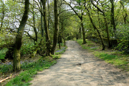
A walk that explores the countryside to the north of Duffield, Derbyshire. The route runs along the top of the Chevin with views of two contrasting valleys, before reaching the outskirts of Duffield. The return route through the Ecclesbourne Valley visits the River Ecclesbourne before climbing uphill to Hazelwood Hill.
The Start is the lay- by on Firestone just south of Farnah Green, opposite the turning to Hazelwood (grid ref. SK336463). From here take the signed public footpath, to the left of the lay-by, to emerge at a crater, reputedly the landing place for one of the few bombs dropped near Belper during the Second World War.
Turn left and follow the yellow arrows, which shortly lead you downhill, between two walls, where there are views to your left across The Dalley to Crich Stand. The route leads you down to North Lane, a Roman road that was used to transport iron-ore mined around Wirksworth to Duffield. Turn right and follow the wooded North Lane along the top of the Chevin. As you walk along North Lane not only are there views across the Derwent Valley to enjoy but depending upon the time of year either wild flowers to admire, conkers to hunt for or possibly blackberries to eat.
Chevin Golf Course will soon appear on your right and then, shortly after, also on your left. After passing a green gate on your right, which is where the golf course first crosses your path, look out for a gap in the wall, also on your right. Signed 'Derwent Valley Walk' go through the gap and head downhill, crossing two more golf course paths, to a wall. Turn right to find another gap in the wall, on the left, which you go through. Emerging from the wooded hillside you are now rewarded with views that extend across Duffield to Duffield Bank and beyond.
Follow the obvious wide green path to head left downhill towards the golf club. The path follows the edge of the golf club to eventually cross a small stream. At the next corner in the field the grass track turns left uphill but you are continuing alongside the golf course, so go straight ahead across the stile/gap in the fence. Exit the field by the stile and turn right along the tarmac track towards the clubhouse. Continue on this path, past the golf club entrance, to emerge onto Avenue Road.
Turn right along Avenue Road until you reach a T-junction where you turn left. Shortly after look out for the public footpath sign on the right-hand side of the road. It is slightly hidden in a hedge and directs you down what appears to be a private drive to 35 The Glen. It isn't a private drive so take the track until very shortly you reach the entrance/gates to number 35. Take the signed path to the right of the house to eventually emerge into fields behind the church.
Follow the obvious path across the fields until you reach the stile onto the railway line. Cross the railway line to another stile. Immediately after crossing the second stile turn right to follow a path that initially runs parallel to the railway. Continue on this path across more fields until you are walking by the River Ecclesbourne. Where the path turns left and crosses the river, on an obvious wide bridge, don't follow it but instead take the footpath to the right, over a stile, into the next field.
Once you have crossed the stile turn right to follow the footpath along the edge of the field and cross back over the railway line. The footpath then bears diagonally to your left to a stile into the next field where you continue straight ahead with the hedge on your left. At the corner of the field take the stile and bridge into the next field and cross the track on the right. Your route is uphill to Hazelwood Hill and not along this track. After negotiating the broken stile follow the track uphill across two fields with the hedge on your right. Exit the second field via a gate and bear right to the farm track. Turn right along the track to the road. Turn left and head uphill.
Opposite Larch Tree Farm take the public footpath on the right to bear diagonally left across the field to a group of trees. Once past these continue in the same direction to the gate/entrance to the field. Turn right and continue along the road and back to the car.
When I did this walk the entrance to the final field was very overgrown and the field had just been planted up with no allowances made for anyone attempting to follow the footpath. It may well be easier to ignore this turn and to continue along the road and to then take the first road on the right back to the car.
Other walks nearby
| Walk 2619 | Belper to Cromford, Amber Valley | moderate | 7.5 miles |
| Walk 2899 | Cromford Canal & Black Rocks from High Peak Junction | easy/mod | 6.8 miles |
| Walk 2993 | Carsington, Brassington & Cromford and High Peak Railway from Middleton | moderate | 9.5 miles |
| Walk 2701 | Harboro Rocks & Brassington | easy/mod | 6.5 miles |
| Walk 3672 | Carsington Water, Hognaston & Madge Hill | easy/mod | 5.5 miles |
| Walk 2627 | Cromford to Bakewell | moderate | 11.5 miles |
| Walk 1378 | Carsington Circular | easy | 4.5 miles |
| Walk 1379 | Carsington and Harboro Rocks | easy/mod | 5.8 miles |
| Walk 2218 | Cocking Tor from near Matlock | moderate | 9.5 miles |
| Walk 2823 | Greasley & Moorgreen Reservoir | easy | 5.9 miles |
Recommended Books & eBooks
Walking in Derbyshire
 Walking guidebook to 60 circular day walks in Derbyshire and the Peak District. Includes the Derwent, Wye and Trent river valleys, near Derby, Matlock, Glossop, Bakewell and Ripley. Routes range from easy to moderate and are between 4 and 14km (2 to 10 miles). Walks focus on places of interest, from Stone Age forts to castles to grand estates.
More information
Walking in the Peak District - White Peak East
 Guidebook describing 42 half-day and day walks in the limestone landscapes of Derbyshire's White Peak, part of the Peak District National Park. One of two volumes, this book covers the east of the region, with potential bases including Bakewell, Eyam, Castleton, Birchover, Matlock and Wirksworth.
More information
Messaging & Social Media
Message Walking Britain and follow the latest news.

Mountain Weather
Stay safe on the mountains with detailed weather forecasts - for iOS devices or for Android devices.