Winscar Reservoir circuit from Dunford Bridge
Peak District Walk
Nat Park - Peak District - Black Hill Dovestone
County/Area - South Yorkshire & West Yorkshire
Author - Andy Chaplin
Length - 8.9 miles / 14.5 km Ascent - 1000 feet / 303 metres
Time - 5 hours 30 minutes Grade - moderate
Maps 

| Ordnance Survey Explorer OL1 | Sheet Map | 1:25k | BUY |
| Anquet OS Explorer OL1 | Digital Map | 1:25k | BUY |
| Ordnance Survey Landranger 100 | Sheet Map | 1:50k | BUY |
| Anquet OS Landranger 100 | Digital Map | 1:50k | BUY |
Walk Route Description
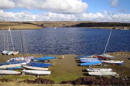
Click image to visit gallery of 3 images.
The car-park side of Winscar reservoir can be very busy but as you head up on open country towards Snailsden it is usually very quiet. On this Peak District walk there are three reservoirs to see, sections of the Kirklees Way and Holme Valley Circular Walk to follow and on the way you pass Elysium as well as Hades - so how come places in West Yorkshire ended up with names like that?
There are three places to park near Winscar reservoir - (1) at SE155030 off the Dunford Road would make this walk the shortest, (2) at SE152020 is closest to the start of the open-country walking or (3) at SE157024 has the largest parking area and is where this description starts.
Leave the Trans Pennine car park (3), cross the main road and walk up Don View road. Keep straight on up the gated road between the gardens on your left and the river Don on the right and after the second gate there is a path that leads up on the left to the top of the reservoir dam wall. Go west towards the sailing club where you meet the road from car park (2) and you will see the gate to the open country just in outside the sailing club entrance.
Follow the path/sheep track around the sailing club fence until going slightly inland to cross the first inlet before the end of the club compound - there are stone "fords" across the streams. Stay on the moors side of the wire fence until you come to a gate before reaching Dearden Clough. Stay close to the water's edge to cross the clough then climb up towards the trees that are the Dearden Foot plantation - again staying on the moors side of the fencing.
This is the end of the open country/sheep path walking because, from the north west of the plantation, there is a moors/shooting track that leads up to an even better maintained moors track at SE141028. Take the right hand fork here and follow the track to the farm near Wetshaw Edge. As you approach it there are signs warning you to keep out, so go around the north of the farm buildings and pick up the track heading north.
After passing through a gap in the next wall follow the track to the left then pick up the path/track that is indicated by wooden posts and leads in a loop around Snailsden Edge. The trig point is just to the north of the track. After approaching Holme Moss transmitter for some time the path then turns north and east then descends towards Snailsden reservoir.
From the reservoir follow the track north and eastwards to the road then go west on Linshaws Road. After just over half a mile go right on the track that is marked as the Kirklees Way and follow it as it goes right again past the farm named Elysium. Shortly before the woods start there is a path off on the right (not marked as such but) which is the Holme Valley Circular Walk. Follow this past the ruined farm at Hades (look out for the stone writing) and carry on back up to Linshaws Road.
Go a little left, cross over and follow the track down to Harden Clough so that you then come along the south of the reservoir. Cross over the Harden reservoir dam wall in order to get onto the Dunford Road which heads back to Winscar Reservoir. After a quarter of a mile a road off on the left leads down to a car park (1) and then the road leads on to the gated road over the reservoir dam wall.
My choice for getting down to the lower Dunford car park (3) was to walk east from the start of the dam wall across Broad Hill Bank, which gives good views down the Don valley, then come back on Brook Hill Lane.
Other walks nearby
| Walk 1401 | Hordron Road and the Little Don | easy/mod | 5.0 miles |
| Walk 2231 | The Eastern Edges | hard | 25.0 miles |
| Walk 1526 | Cats Clough Head & Outer Edge | moderate | 9.0 miles |
| Walk 1695 | Flouch & Winscar circular | easy/mod | 9.0 miles |
| Walk 3174 | Saltersbrook and Lady Cross from Woodhead | easy/mod | 6.0 miles |
| Walk 1756 | Bleaklow & The Longendale Trail from Woodhead | mod/hard | 10.0 miles |
| Walk 1829 | Holme & Marsden Clough from Ramsden Reservoir | moderate | 9.0 miles |
| Walk 1581 | Langsett Reservoir | easy | 3.0 miles |
| Walk 3401 | From Langsett to Crowden via Woodhead | moderate | 11.0 miles |
| Walk 2630 | Upper Holme Valley & Ramsden Clough | moderate | 9.0 miles |
Recommended Books & eBooks
Dark Peak Walks
 Guidebook to 40 walks in the Dark Peak area of the Peak District National Park. 35 circular routes for most abilities, from 8km to 19km, around Edale, Marsden, Fairholmes, Baslow and Castleton, including Kinder Scout and Mam Tor, and 5 longer (25km to 45km) routes highlighting the best of the Gritstone Edges, High Moorland and Deep Valleys.
More information
Walking in the Peak District - White Peak East
 Guidebook describing 42 half-day and day walks in the limestone landscapes of Derbyshire's White Peak, part of the Peak District National Park. One of two volumes, this book covers the east of the region, with potential bases including Bakewell, Eyam, Castleton, Birchover, Matlock and Wirksworth.
More information
Messaging & Social Media
Message Walking Britain and follow the latest news.

Mountain Weather
Stay safe on the mountains with detailed weather forecasts - for iOS devices or for Android devices.