Walk 2831 - printer friendly version
Cranoe, Medbourne & Blaston from Hallaton Walk
Author - Lou Johnson
Length - 11.5 miles / 18.7 km
Ascent - 700 feet / 212 metres
Grade - moderate
Start - OS grid reference SP788965
Lat 52.5606390 + Long -0.8390258
Postcode LE16 8UA (approx. location only)
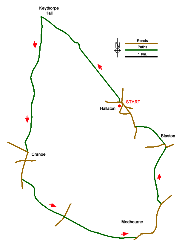
This Leicestershire walk explores the rolling countryside to the northwest of Hallaton before turning south and then east through flatter landscapes to return to the start. The route uses paths and bridleways which for the most part are well used and signed. However, it is a good idea to take along the relevant OS Explorer map to help with navigation.
The start is the village of Hallaton (grid ref. SP788965). On street parking is available although be considerate for local residents. There is a pub (Bewicke Arms) located in the centre of the village. Walk north out of the village on the road to East Norton passing the village pond on your right. Just past the pond take the signed footpath on your left. This leads across fields to join a bridleway at grid ref. SP768972. Continue north-west along the bridleway passing Moor Hill Spinney on your right. The route briefly joins a track by Hallaton Spinneys before continuing to reach the farm buildings at Keythorpe Hall (grid ref. SP765993).
Turn left along the Midshires Way and continue in a southerly direction for just over four kilometres to reach Church Hill Road at Cranoe (grid ref. SP761953). Walk south along this road with the church to your left to reach a crossroads (grid ref SP760950). Go straight across along Welham Road still following the Midshires Way. After 600 metres or so you reach Churchfield House on your left. Turn left through the wooden gates and follow the bridleway towards Medbourne. You cross another Welham Road and Green Lane to reach Ashley Road (B664) on the southern edge of Medbourne.
Turn left towards Medbourne following the B664 into the village using the pavement on the right hand side of the road. In the centre of the village at a grass traffic island bear left onto the Uppingham Road. You pass the substantial parish church on your left, walk along Main Street, cross the old railway, and after 800 metres (grid ref. SP801937) turn left into Field Road signed to Blaston. After a short stretch of tarmac, the way ahead follows a clear track across fields to reach the village of Blaston (grid ref. SP803954). Turn left and at the next road junction after 100 metres continue straight ahead into gated Horninghold Lane. Bear left onto the signed footpath across fields to reach Medbourne Road (grid ref. SP793961). Turn right and you are soon back in the village of Hallaton.
Messaging & Social Media
Message Walking Britain and follow the latest news.

Mountain Weather
Stay safe on the mountains with detailed weather forecasts - for iOS devices or for Android devices.