Wootton Wawen from Edstone Aqueduct
Warwickshire Walk
County/Area - Warwickshire
Author - Peter Lane
Length - 8.0 miles / 13 km Ascent - 500 feet / 152 metres
Time - 4 hours 30 minutes Grade - easy/mod
Maps 

| Ordnance Survey Explorer 220 | Sheet Map | 1:25k | BUY |
| Anquet OS Explorer 220 | Digital Map | 1:25k | BUY |
| Ordnance Survey Landranger 151 | Sheet Map | 1:50k | BUY |
| Anquet OS Landranger 151 | Digital Map | 1:50k | BUY |
Walk Route Description
Click image to visit gallery of 12 images.
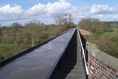
Water courses hold a fascination for many and this walk along the Stratford upon Avon Canal has good reason for doing so. Two rare aqueducts along the course of this route bear the canal across bridges in cast iron conduits built in the early 19th Century. This easy circular walk also visits some of pleasant rural Warwickshire and there is the opportunity for a drink at the Navigation Inn without leaving the course of the route!
Start at the base of the Edstone Aqueduct itself near Bearley Cross at grid reference SP163608, where there is a small parking area. Climb the flight of stairs up to the aqueduct and take a look at its engineering magnificence because Edstone is the longest aqueduct in England. There is a plaque at the opposite end of the aqueduct giving information on its construction and restoration, but this can be enjoyed on the way back.
Head roughly South down the towpath until reaching the second bridge (No. 58). Here there is a waymark to the left and a stile with a path leading to a railway crossing. Cross over carefully and continue along this path as it curves right and goes uphill along an avenue lined with poplar trees. At the end of this avenue the path turns sharp left. In approximately 50 metres there is a gap in the hedge on the left, where a right of way extends across an open field. Head for the obvious telegraph pole in the direction indicated and then keep going in the same direction towards a large oak tree. Cross over the drainage ditch at the sole obvious crossing point.
Continue in roughly the same direction, (north east), across the next field; passing a small woodland on your right. Carry on straight, keeping the old hedgerow on your right side, until you reach a second drainage ditch. Cross over the ditch and turn right (due East) across the middle of the next field, keeping to the high point of the land, towards the A3400 main road. Head down a set of steps to the roadway and cross over the road. The bridlepath to continue the walk is approximately 40 metres to your left (North). Follow it all the way to Bearley, emerging onto Ash Lane.
At the end of Ash Lane turn right for a short distance along a secondary road and opposite a small Church turn left up Old Snitterfield Road which becomes School Lane and then a muddy bridlepath! Follow this to another railway crossing (there's two of these in the field, aim for the left hand one) and then a secondary road. Turn right here and then, in a short distance, turn left. Follow this well made road over a pair of bridges over the at Edstone to Cutler's Farm. (You are now on the Monarch's Way and can follow it's waymarks back as far as Wootton Wawen).
In the middle of the farm complex, turn left along a waymarked path and follow the boundary of the farm building until the wood on the hill is directly ahead. Head for the wood, keeping the hedge to the left once part way up. At the summit the path veers slightly right but then goes soon through a gate on the left into Austy Wood. (If you're doing this walk around April there will be many bluebells in this wood). The path is never in any doubt here and continues without remark until it reaches the Stratford upon Avon Canal once more.
Turn South along the canal and at the large wharf that opens up ahead, the inviting Navigation Inn appears, which can be reached via a bridge. Alternatively, take the roadway to the right and visit the (signposted) Craft Centre and maybe the village of Wootton Wawen itself. Adjacent to the Navigation Inn is another shorter aqueduct built in 1813 and an information board.
In any event, the return route to Edstone Aqueduct is a simple matter of following the towpath South. Take some time to admire the thick cast iron sections, the bolts, seals and wonder at the fact that the canal still holds water after nearly 200 years! There is a small seating area on the Northern end of Edstone aqueduct ideal for admiring the scene if nobody beats you to it!
Other walks nearby
| Walk 3016 | Preston Bagot & Finwood from Henley-in-Arden | easy/mod | 7.0 miles |
| Walk 3105 | Preston Bagot from Henley-in-Arden | easy | 4.7 miles |
| Walk 2711 | Henley-in-Arden Circular | easy/mod | 5.5 miles |
| Walk 3700 | West from Henley-in-Arden | easy | 5.5 miles |
| Walk 2673 | Stratford-upon-Avon circular | easy | 3.8 miles |
| Walk 3702 | Coughton Circular | easy/mod | 6.8 miles |
| Walk 1345 | Alcester Town & Country Circular | easy/mod | 7.0 miles |
| Walk 1359 | Stratford-upon-Avon from Milcote | easy/mod | 7.0 miles |
| Walk 3235 | Studley Circular | easy/mod | 8.3 miles |
| Walk 3716 | Morton Bagot & Bannam's Wood from Studley | easy/mod | 8.4 miles |
Recommended Books & eBooks
No suggestions for this area.Messaging & Social Media
Message Walking Britain and follow the latest news.

Mountain Weather
Stay safe on the mountains with detailed weather forecasts - for iOS devices or for Android devices.