Walk 2930 - printer friendly version
Roseberry Topping from Newton under Roseberry Walk
Author - Lou Johnson
Length - 3.2 miles / 5.2 km
Ascent - 600 feet / 182 metres
Grade - easy
Start - OS grid reference NZ570128
Lat 54.5073170 + Long -1.1212168
Postcode TS9 6QS (approx. location only)
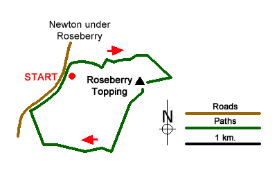
Roseberry Topping is an easily recognised North York Moors hill that offers some wonderful views over the surrounding countryside and moorland. The start of this walk is carpark off the A173 on the south side of the village of Newton under Roseberry.
After parking walk to the northern end of the parking area and take the path through trees to reach Roseberry Lane. Turn right along the lane and climb very gently to reach a junction of paths and tracks at the western edge of Newton Wood (grid ref. NZ574128). Bear left here and continue along the lane. Go through the first gate and at the second date bear right uphill. You are now on Brant Gate path. At the first fork in the path go left. The path climbs steadily and veers to the right. At this point take the left hand path and continue through a gate.
After the gate stay on the main path and take the second path on the right (grid ref. NZ579129). Follow this rising path as it climbs gently around Roseberry Topping until it reaches a fence (grid ref. NZ5832126). Turn right here and follow the path alongside the wall to reach the summit. After having enjoyed the views, turn south-east from the summit descending quite steeply to reach a fence. Turn right along the fence losing height down to a gate (grid ref. NZ577123). Go through the gate and take the left-hand footpath and continue in a southerly direction to reach a path junction (grid ref, NZ575117).
Turn right and follow the path which after one field enters the southern end of Newton Wood. Continue down through the wood to reach a track that leads down to cross the railway. Just before crossing the railway, turn right and take the path running parallel to the railway north towards the A173. Turn right along this often busy main road. Initially the path is on the grass verge of the road but you soon reach a stile on your right. Cross the stile and turn left to follow the path through fields running parallel to the road. This path leads back to the start.
Messaging & Social Media
Message Walking Britain and follow the latest news.

Mountain Weather
Stay safe on the mountains with detailed weather forecasts - for iOS devices or for Android devices.