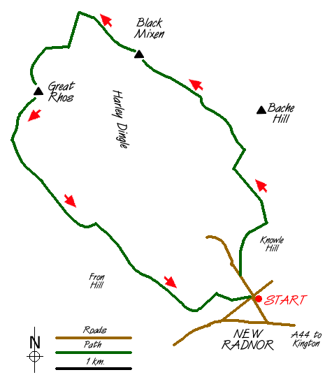
Great Rhos & the Radnor Forest from New Radnor Walk
Walk 3023 - Route Maps
Sketch Map
Suggested Maps 

| Ordnance Survey Explorer 200 | Sheet Map | 1:25k | BUY |
| Anquet OS Explorer 200 | Digital Map | 1:25k | BUY |
| Ordnance Survey Explorer 201 | Sheet Map | 1:25k | BUY |
| Anquet OS Explorer 201 | Digital Map | 1:25k | BUY |
| Ordnance Survey Landranger 148 | Sheet Map | 1:50k | BUY |
| Anquet OS Landranger 148 | Digital Map | 1:50k | BUY |
It is recommended you take a map. The preferred scale is 1:25k.
Start Point Details
Ordnance Survey Grid Ref SO212609
Latitude 52.240624 Longitude -3.155445
Postcode LD8 2TD
what3words start vows.series.rejoin
Walk description may contain detailed information on the start point for this walk.
Further Information
Powys
Powys is a large county in east and central Wales, bordering England. The county features a rugged landscape of valleys and mountains, including most of Brecon Beacons National Park. The valley lowlands contrast with the highlands which include the Radnor Forest, the Black and Berwyn mountains, and the Brecon Beacons. The Offa's Dyke long distance path crosses the county on the eastern border with England. The county offers a wide range of walking from gentle valley paths to adventurous mountain walks.
Walk grading - Learn how each walk is assessed and select a walk to suit your ability and experience by going to Walk Grading Details.
Messaging & Social Media
Message Walking Britain and follow the latest news.

Mountain Weather
Stay safe on the mountains with detailed weather forecasts - for iOS devices or for Android devices.