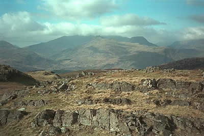
North West of Blaenau Ffestiniog from Crimea Pass
Snowdonia/Eryri Walk
Nat Park - Snowdonia - Moelwyns Moel Siabod Cnicht
County/Area - Conwy
Author - Lou Johnson
Length - 8.5 miles / 13.8 km Ascent - 2080 feet / 630 metres
Time - 6 hours 20 minutes Grade - mod/hard
Maps 

| Ordnance Survey Explorer OL17 | Sheet Map | 1:25k | BUY |
| Anquet OS Explorer OL17 | Digital Map | 1:25k | BUY |
| Ordnance Survey Explorer OL18 | Sheet Map | 1:25k | BUY |
| Anquet OS Explorer OL18 | Digital Map | 1:25k | BUY |
| Ordnance Survey Landranger 115 | Sheet Map | 1:50k | BUY |
| Anquet OS Landranger 115 | Digital Map | 1:50k | BUY |
Walk Route Description
Click image to visit gallery of 2 images.
There are many areas of high ground in Britain which are neglected by walkers. The area to the north west of the slate town of Blaenau Ffestiniog is one such place. Here boot marks in the path are hard to find and there is no one to talk to apart from yourself and the mountains.
This Snowdonia (Eryri) walk starts at the small car park at the summit of Crimea Pass on the A470 from Betws y Coed to Bleanau Ffestiniog (grid ref SH701490). Walk up the main road to the track that comes in from the north. Ignore the track, instead climbing steeply westwards over grass to gain the ridge. The onward route to the summit of Allt-fawr is obvious with dramatic views into the huge slate quarries on your left.
The next objective is Moel Druman which is most easily reached by heading to the north of Llyn Conglog. All too soon you have reached the second summit of the day. The views from here include many of the major peaks of northern Snowdonia (Eryri) including Snowdon and its satellites. Heading north west and following the fence the multi-topped peak of Ysgafell Wen is soon reached. Note the stile on your right hand side as you will return here after visiting Ysgafell Wen. There are excellent views from here to Snowdon and the other northern peaks of Snowdonia (Eryri) including the Glyders and the Carneddau.
Retrace your steps to the stile and head east keeping the fence to your right as you descend into a broad valley. In places the path fades but provided you keep the fence in sight you cannot go too far wrong. Some caution is needed on this section as there is one section of steep ground with crags but with care these can be easily negotiated. As you descend you will approach a gully just to the south of Moel Lledr. The easiest route is to be found on the east bank of the river with care needed to avoid some crags.
Reaching the bottom of the gully you encounter some boggy ground. The 'target' is the track heading back to the top of the Crimea Pass. This was accomplished by trial and error with some back-tracking necessary to avoid the worst of the soft ground. However eventually you will reach the track and all that remains is an easy walk back to the car. Apparently this track was the old road across the pass and you have plenty of time to admire the cleverly constructed route with its well designed gradients so necessary when horses were the only source of power.
Other walks nearby
| Walk 1334 | Cnicht from Tanygrisiau | moderate | 8.0 miles |
| Walk 3058 | Llyn yr Adar & Llyn Edno from near Bethania | moderate | 9.0 miles |
| Walk 1192 | Yr Aran | mod/hard | 6.5 miles |
| Walk 1103 | Snowdon & Cwm Llan horseshoe | very hard | 13.0 miles |
| Walk 2290 | Snowdon via the Watkin Path & South Ridge from Bethania | mod/hard | 8.0 miles |
| Walk 1136 | Yr Aran (Route 2) | moderate | 5.5 miles |
| Walk 1515 | Tops and Tarns of the Moelwyns | mod/hard | 11.0 miles |
| Walk 1127 | Cnicht | moderate | 6.3 miles |
| Walk 3035 | The Moelwyns | mod/hard | 7.5 miles |
| Walk 1010 | Cnicht, Moel Druman & Allt-fawr | moderate | 10.0 miles |
Recommended Books & eBooks
Snowdonia: 30 Low-level and easy walks - South
 Guidebook describing 30 walks in Snowdonia, Wales. Routes are mostly low level and on clear paths and showcase the region's beautiful scenery and rich history and culture. Part of a 2-volume set, this southern volume includes Trawsfynydd, Bala, Dolgellau, Machynlleth, the Harlech Coast and the valleys of the Mawddach and Dyfi.
More information
Snowdonia: 30 Low-level and easy walks - North
 Guidebook describing 30 walks in Snowdonia, Wales. Routes are mostly low level and on clear paths and showcase the region's beautiful scenery and rich history and culture. Part of a 2-volume set, this northern volume includes the Snowdon area, the Ogwen and Conwy Valleys, Betws-y-Coed, Beddgelert, Ffestiniog and the coast.
More information
Messaging & Social Media
Message Walking Britain and follow the latest news.

Mountain Weather
Stay safe on the mountains with detailed weather forecasts - for iOS devices or for Android devices.