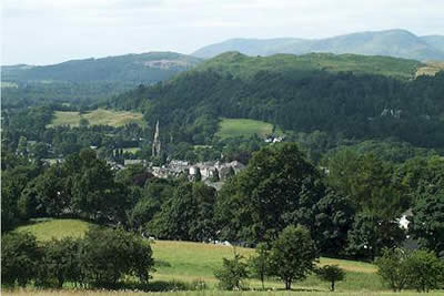
Red Screes & Other Fells from Ambleside
Lake District Walk
Nat Park - Lake District - Lake District Eastern Fells
Wainwrights - High Hartsop Dodd, Little Hart Crag, Middle Dodd, Red Screes
County/Area - Cumbria
Author - Lou Johnson
Length - 10.0 miles / 16.3 km Ascent - 2700 feet / 818 metres
Time - 7 hours 40 minutes Grade - mod/hard
Maps 

| Ordnance Survey Explorer OL7 | Sheet Map | 1:25k | BUY |
| Anquet OS Explorer OL7 | Digital Map | 1:25k | BUY |
| Ordnance Survey Landranger 90 | Sheet Map | 1:50k | BUY |
| Anquet OS Landranger 90 | Digital Map | 1:50k | BUY |
Walk Route Description
Click image to visit gallery of 6 images.
This is a lake District walk with a difference. Red Screes is the main focus of the walk but I have added three lesser summits all of which are Wainwrights. With all the car parks in Ambleside heaving with visitors some lateral thinking was needed and I headed up the road to Kirkstone Pass as far as the small parking area (grid ref. NY388057) just uphill from Roundhill farm. If everyone parks carefully there is enough room for half a dozen cars and it provides a pleasant start to this varied walk.
Sadly you first need to cover a short distance on the road. Head downhill until you are level with High Barn where you take a footpath on your right that trends west around the northern outskirts of Ambleside. Simple navigation will lead to the lane heading north up Scandale. A pleasant section through woodland leads to open country beyond and High Sweden Bridge, by which time you are probably ready for a rest. Continuing, keep to the main path which heads up the valley to Scandale Pass. You have a rather uninteresting view of Red Screes on your right and the crags of Low Pike and High Pike to your left. Ahead you will see the twin tops of Little Hart Crag on the skyline and these are the first objective of the day.
Progress up Scandale is easy and it is surprising how quickly you reach the top of the Pass. Turn left up the fellside to reach the summit cairn of Little Hart Crag from where there are good views north. I have always been determined to reach the top of High Hartsop Dodd but the direct approach from Brother's Water looks intimidating but by descending from Little Hart Crag and following the ridge you are able to reach the top by walking downhill all the way! After admiring the view, I turned south carefully avoiding any re-ascent by contouring across the eastern slopes of Little Hart Crag to arrive back at Scandale Pass.
It is a long tedious approach to the summit of Red Screes. This can be avoided at least in part by heading south-east alongside the wall and then turning north across rough fellside to the little summit of Middle Dodd. By doing this you avoid much of the tedium and are rewarded with much more interesting views. The summit is a fine place to rest awhile and you will probably be alone and able to enjoy the view, which is excellent especially to north and east. Although this diversion adds a little extra distance it significantly improves the final ascent to the summit of Red Screes as you are able to see at close quarters its north east combe, which is very dramatic. As an extra bonus you have a bird's eye view of the traffic crossing the Kirkstone Pass which looks a long way down.
With so much to see you soon arrive at the summit of Red Screes which is adorned with a trig point and, rather surprisingly, a small tarn. From now on it is all down hill. I used the main path back to Ambleside which follows the ridge. Ahead is an excellent panorama over Windermere with a good selection of the southern and western peaks as a backdrop. Reaching the Kirkstone Road turn left and walk a short way uphill back to your car and the end of an excellent mountain excursion.
Other walks nearby
| Walk 1002 | The Fairfield Horseshoe | mod/hard | 11.0 miles |
| Walk 1170 | Fairfield Horseshoe (short route) | mod/hard | 9.5 miles |
| Walk 1023 | Wansfell Pike & Wansfell | easy/mod | 7.5 miles |
| Walk 3519 | High Sweden Bridge | easy/mod | 3.0 miles |
| Walk 3075 | Rydal Water & Loughrigg from Ambleside | easy/mod | 6.5 miles |
| Walk 3423 | Dove Crag & Red Screes - Scandale Horseshoe | mod/hard | 9.5 miles |
| Walk 2026 | Loughrigg from Pelter Bridge near Rydal | easy/mod | 4.0 miles |
| Walk 1823 | Fairfield Horseshoe & Loughrigg from High Close | mod/hard | 14.0 miles |
| Walk 3697 | Loughrigg Fell from Skelwith Bridge | easy/mod | 4.5 miles |
| Walk 1472 | Alcock Tarn & Rydal Water | easy/mod | 7.0 miles |
Recommended Books & eBooks
Walking the Lake District Fells - Keswick
 Part of the Walking the Lake District Fells series, this guidebook covers a wide range of routes to 30 Lakeland summits that can be climbed from Keswick, Whinlatter, Bassenthwaite, Caldbeck, Mungrisdale and Threlkeld, with highlights including Skiddaw and Blencathra. Includes suggestions for longer ridge routes.
More information
The Cumbria Way
 A guidebook to the 73 mile Cumbria Way, an easy long-distance walk though the heart of the Lake District National Park, from Ulverston in the south to Carlisle in the north, with good transport links to either end. The route is largely low-level but this guide offers alternative mountain days to climb some of the famous fells en route.
More information
Messaging & Social Media
Message Walking Britain and follow the latest news.

Mountain Weather
Stay safe on the mountains with detailed weather forecasts - for iOS devices or for Android devices.