Moel Eilio from Llanberis
Snowdonia/Eryri Walk
Nat Park - Snowdonia - Snowdon Crib Goch
County/Area - Gwynedd
Author - Lou Johnson
Length - 7.0 miles / 11.4 km Ascent - 2300 feet / 697 metres
Time - 5 hours 50 minutes Grade - moderate
Maps 

| Ordnance Survey Explorer OL17 | Sheet Map | 1:25k | BUY |
| Anquet OS Explorer OL17 | Digital Map | 1:25k | BUY |
| Ordnance Survey Landranger 115 | Sheet Map | 1:50k | BUY |
| Anquet OS Landranger 115 | Digital Map | 1:50k | BUY |
Walk Route Description
Click image to visit gallery of 6 images.
This quiet, rewarding Snowdonia (Eryri) walk from Llanberis takes in one of the lesser known summits of the Snowdon range. Rising to 726 metres, the summit Of Meol eilio offers good views of a wide range of mountains in the northwestern sector of the Snowdonia National Park.
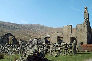
The distance and height gain is quoted from Maen-llwyd-isaf (Grid ref. SH567595). This derelict farmstead has limited parking nearby and can be reached up a gated road from the centre of Llanberis, leaving the main street by Fford Capel which leads to the Youth Hostel and then turning right by the chapel. For those without transport, the start can be gained by walking the same route and taking a more direct return at the end of the walk.
After parking continue through the gate to the right of the farmstead and walk up the track, which heads north before turning west. Reaching an open area after passing through a gate look out for the path that goes left climbing steadily over grass. Initially southwest, the path improves and turns south to follow a derelict wall. The ascent is steady and you are joined by another path coming in from your left. One final pull and you are on the summit. The views are excellent and you may be hard pressed to name all the summits that can be seen.
Descend south on a clear path over an unnamed summit (629 metres), Foel Gron (593 m.) to reach Foel Goch (605 m.). The going is easy over grass. Despite the undulations along the ridge, with Snowdon ahead you make steady progress. To your left there are crags with Llyn Dwythwch far below.
From Foel Goch the route heads just east of north descending down a broad ridge. There is a path of sorts on the initial descent although it fades when you reach a flatter area of marshy ground. The best idea is to keep right over this section making sure you do not descend into the valley of Maesgwm. Ahead you will see a ladder stile (Approx. grid ref. SH 575572) and this is the next objective. Cross this and head to another stile which can be seen in good visibility roughly north of the first stile. Staying on this heading you will descend over rough grass and rock to reach another stile over a wall (Approve grid ref. SH 574579). From here a more distinct path emerges and this lead to a track. Turn right along the track to reach another track at Brithdir. Turn left and continue along the track to reach a house (Grid ref. 573591) where you join a bridleway that leads back to the start.
Other walks nearby
| Walk 2626 | Snowdon & Garnedd Ugain from Llanberis | moderate | 9.3 miles |
| Walk 1003 | Snowdon by the Llanberis Path | moderate | 9.0 miles |
| Walk 1681 | Moel Eilio & Moel Cynghorion from Llanberis | mod/hard | 10.0 miles |
| Walk 3613 | Moel Cynghorion from Llyn Cwellyn | moderate | 5.0 miles |
| Walk 1453 | Elidir Fawr, Mynydd Perfedd & Marchlyn Mawr reservoir | moderate | 6.0 miles |
| Walk 1131 | Mynydd Mawr & Fron | easy/mod | 4.0 miles |
| Walk 2590 | Nantlle Ridge Walk from Rhyd Ddu (Route A) | moderate | 6.0 miles |
| Walk 2797 | Yr Aran and Snowdon from Rhyd-Ddu | mod/hard | 8.5 miles |
| Walk 3509 | Nantlle Ridge from Rhyd Ddu (Route B) | mod/hard | 8.3 miles |
| Walk 3198 | Snowdon via the South Ridge & Rhyd-ddu Path | mod/hard | 7.5 miles |
Recommended Books & eBooks
The Cambrian Way
 Guidebook to the Cambrian Way, a challenging three-week mountain trek through Wales from Cardiff to Conwy. The 470km un-waymarked route is presented from south to north. Often sticking to long, beautiful ridgelines, it crosses wild and rugged terrain and visits many of Wales's highest mountains, including Snowdon.
More information
Snowdonia: 30 Low-level and easy walks - South
 Guidebook describing 30 walks in Snowdonia, Wales. Routes are mostly low level and on clear paths and showcase the region's beautiful scenery and rich history and culture. Part of a 2-volume set, this southern volume includes Trawsfynydd, Bala, Dolgellau, Machynlleth, the Harlech Coast and the valleys of the Mawddach and Dyfi.
More information
Messaging & Social Media
Message Walking Britain and follow the latest news.

Mountain Weather
Stay safe on the mountains with detailed weather forecasts - for iOS devices or for Android devices.